Tanimbar Islands
The Tanimbar Islands, also called Timur Laut, are a group of about 65 islands in the Maluku province of Indonesia, including Fordata, Larat, Maru, Molu, Nuswotar, Selaru, Selu, Seira, Wotap, Wuliaru and Yamdena. The Indonesian phrase timur laut means "east of the sea" or "northeast".
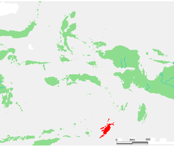
The Tanimbar Islands are administered as the Tanimbar Islands Regency (Indonesian: Kabupaten Kepulauan Tanimbar), a regency of Maluku. The Regency covers a land area of 4,465.79 sq.km, and it had a population of 105,341 at the 2010 Census;[1] the latest official estimate (as of January 2014) was 117,341. The principal town and administrative centre lies at Saumlaki.
Geography
Geographically, the northeast islands are still part of the Lesser Sunda Islands. The Aru Islands and Kai Islands lie to the northeast, and Babar Island and Timor lie to the west. The islands separate the Banda Sea and the Arafura Sea. The total land area of the Islands is 5440 km² (2100 sq mi).
The largest of the group is Yamdena. Yamdena Island has a range of thickly forested hills along its eastern coast, while its western coast is lower. Saumlaki is the chief town, located on the south end of Yamdena. Other islands include Larat, Selaru, and Wuliaru.
The population was 105, 341 at the 2010 Census,[2] of whom about 94% are Christian, and the remainder Muslim or other.[3] The tiny island of Tanimbarkei is not part of Tanimbar, but of the Kai Islands and inhabited by less than 1000 very traditional people.
The Tanimbar Islands are part of the Banda Sea Islands moist deciduous forests ecoregion.
History

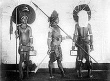
In modern history, the Tanimbar islands (as the Aru Islands) were mentioned in the 16th century maps of Lázaro Luís (1563), Bartolomeu Velho (c. 1560), Sebastião Lopes (1565), in the 1594 map of the East Indies entitled Insulce Molucoe by the Dutch cartographer Petrus Plancius, and in the map of Nova Guinea of 1600 (based on Portuguese sources). The Tanimbar Islands were sighted and possibly visited by Portuguese navigators such as Martim Afonso de Melo Jusarte around 1522–1525, who traveled around the archipelagos of Aru (with the reference "Here wintered Martin Afonso de Melo") and Tanimbar, and possibly Gomes de Sequeira in 1526.[4]
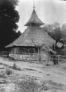
The Tanimbar Islands were part of the Dutch East Indies. During World War II the Dutch sent a detachment of 13 soldiers to the town of Saumlaki in the Tanimbar Islands in July 1942. Japanese ships entered the bay at Saumlaki on 30 July and small boats were used to get to the jetty. The Japanese filed in ranks on the jetty and wanted to march in close order into Saumlaki. The garrison opened fire at close range with their two light machine guns. The Japanese retreated to their boats leaving several dead on the jetty. Subsequent enemy landings, however, were made elsewhere while the Japanese ships opened fire on the defenders’ position. Six of the Dutch soldiers were killed and the survivors were driven into the bush. On 31 July, a vessel carrying an Australian Army contingent arrived at the jetty at Saumlaki, unaware that the town had fallen to the Japanese. The vessel was fired on from the shore, and the commander of the landing party was killed. The Australians retreated to Darwin. Afterwards, the members of the Dutch garrison came under naval gunfire from the Japanese; this inflicted some casualties, and was followed by attacks by Japanese unfantry on a wider front. Seven surviving members of tbe garrison then boarded a sailing ship and escaped to Australia.[5]
Economy
Important products are copra, tortoiseshell, and trepang (an edible sea cucumber). Recently, the Japanese oil and gas corporation, Inpex intended to develop the Masela Block Project with billions of tonnes of natural gas produced. Offshore facilities will be located on the Tanimbar Island.[6] .
Fauna
- Morelia nauta
- Tanimbar corella
- Tanimbar bush-warbler
- Tanimbar megapode
- Tanimbar starling
- Moluccan masked owl
- Fawn-breasted thrush
- Blue-streaked lory
- Bastilla missionarii
- Troides riedeli
- Etiella chrysoporella
See also
- Islands of Indonesia
- Kei-Tanimbar languages
Notes
- Biro Pusat Statistik, Jakarta, 2011.
- "Population by Region, Type of Document, and Sex". Badan Pusat Statistik. Retrieved 29 June 2017.
- "Population by Region and Religion". Badan Pusat Statistik. Retrieved 29 June 2017.
- Continent of Curiosities: A Journey Through Australian Natural History - Danielle Clode, Cambridge University Press, Page 26
- L, Klemen (1999–2000). "The Banda Sea Operations 1941-1942". Forgotten Campaign: The Dutch East Indies Campaign 1941-1942.
- "POD Blok Masela oleh Inpex Akan Disetujui Akhir Tahun 2018". Lelemuku.com. Retrieved 14 November 2018.
References
- L, Klemen (1999–2000). "Forgotten Campaign: The Dutch East Indies Campaign 1941-1942".
External links
| Wikimedia Commons has media related to Tanimbar Islands. |
| Authority control |
|
|---|