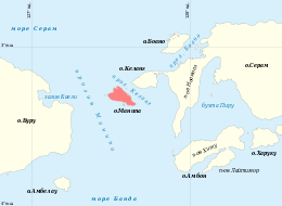
Manipa
Manipa Island is an island in West Seram Regency[1], Maluku Province, Indonesia. It is located 8 km off the western coast of Kelang at the western end of Seram Island and 25 km off the western coast of Buru. The inhabitants speak the Manipa language, as well as Indonesian and Ambonese Malay.[2]
 Location of Manipa | |
 | |
| Geography | |
|---|---|
| Location | South East Asia |
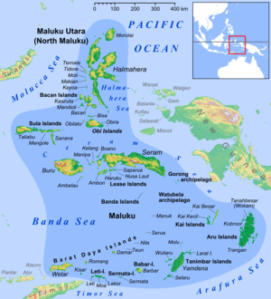
| Archipelago | Maluku Islands |
| Highest elevation | 632 m (2,073 ft) |
| Highest point | Kala Huhun |
| Administration | |
This island gives its name to the Manipa Strait between Buru and Seram.
Adjacent islands
Manipa has a number of small islands that are very close to its shores.[3]
- Masawi and Asamamonuke on a reef on its northeastern coast.
- Suanggi off its western tip. It is located in the Manipa Strait between Buru and Seram. 3°18′S 127°28′E[4]
- Tuban in the south
- Luhu in the north.
References
- http://loketpeta.pu.go.id/assets/cms/uploads/images/media-peta/peta-infrastruktur/pii-8100/2013/8106SeramBagianBarat.jpg
- "Ethnologue 15 report for Indonesia (Maluku)". Archived from the original on 2016-03-04. Retrieved 2013-05-14.
- Pub164, 2004 Sailing Directions (Enroute): New Guinea
- Tanjung Utara Pulau Suanggi - Indonesia Dive Directory Archived 2015-12-22 at the Wayback Machine
External links
This article is issued from Wikipedia. The text is licensed under Creative Commons - Attribution - Sharealike. Additional terms may apply for the media files.