Tanimbar Islands Regency
Tanimbar Islands Regency (Indonesian: Kabupaten Kepulauan Tanimbar) is a regency of Maluku province, Indonesia, consisting primarily of the Tanimbar Islands. The Regency covers a land area of 10,102 km2, and it had a population of 105,341 at the 2010 Census[1] and 110,425 at the 2015 Census; the latest official estimate (as at 2017) was 122,337. The principal town and administrative centre lies at Saumlaki.
Tanimbar Islands Regency Kabupaten Kepulauan Tanimbar | |
|---|---|
 Seal | |
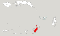 Location within Maluku | |
| Coordinates: 7.9742°S 131.3049°E | |
| Country | Indonesia |
| Province | Maluku |
| Capital | Saumlaki |
| Government | |
| • Regent | Petrus Fatlolon |
| • Vice Regent | Agustinus Utuwaly |
| Area | |
| • Total | 10,102.00 km2 (3,900.40 sq mi) |
| Population (2017) | |
| • Total | 122,337 |
| • Density | 12/km2 (31/sq mi) |
| Time zone | UTC+9 (IEST) |
| Area code | (+62) 918 |
| Website | mtbkab |

History
The regency was formerly named Western Southeast Maluku Regency (Kabupaten Maluku Tenggara Barat), until it was renamed as Tanimbar Islands Regency (Kabupaten Kepulauan Tanimbar) on 23 January 2019; the legislation for this was passed on 28 January 2019. [2][3][4]
Administration
As at 2010 the regency was divided into nine districts (kecamatan), tabulated below with their areas in km2 and their 2010 Census populations:[5] Subsequently, a tenth district - Molu Maru (consisting of the two northernmost islands in the Tanimbars - Molu and Maru - with a combined land area of 63.8 km2) - was by 2017 created from part of the existing Wuor Labobar District. The districts' populations at the 2015 Census are also shown.[6]
| Name | Area in km2 | Population Census 2010 | Population Census 2015 |
|---|---|---|---|
| Wuar Labobar | 1,045.4 | 9,907 | 7,476 |
| Molu Maru | (a) | (a) | 2,908 |
| Wer Makatian | 954.1 | 10,905 | 11,431 |
| Selaru (Selaru Island) | 349.2 | 12,249 | 12,841 |
| Tanimbar Selatan (South Tanimbar) | 358.2 | 31,571 | 33,094 |
| Wer Tambrian | 518.0 | 9,708 | 10,177 |
| Kormomolin | 304.0 | 5,921 | 6,207 |
| Nirunmas | 377.7 | 7,044 | 7,384 |
| Tanimbar Utara (North Tanimbar) | 456.9 | 13,226 | 13,865 |
| Fordata (Fordata Island) | 31.6 | 4,810 | 5,042 |
Note: (a) the area and 2010 population of Molu Maru district are included in the figures for Wuar Labobar district, from which it was split off. Yaru District was change name to Fordata District [7]
References
- Biro Pusat Statistik, Jakarta, 2011.
- "PP NOMOR 2 TAHUN 2019, MTB MENJADI KEPULAUAN TANIMBAR" (in Indonesian). Retrieved 1 February 2019.
- "Maluku Tenggara Barat Resmi Ganti Nama Jadi Kepulauan Tanimbar" (in Indonesian). Retrieved 2 February 2019.
- Peraturan Pemerintah Nomor 2 Tahun 2019 (PDF) (in Indonesian). The Government of Indonesia.
- Biro Pusat Statistik, Jakarta, 2011.
- Badan Pusat Statistik, Jakarta, 2019.
- Inilah Alasan Perubahan Nama Kecamatan Yaru ke Fordata (in Indonesian). Lelemuku.com.
External links
| Wikimedia Commons has media related to Tanimbar Islands Regency. |