Sudurpashchim Pradesh
Sudurpashchim Pradesh (Nepali: सुदूरपश्चिम प्रदेश) (Far-West Province) is one of the seven provinces established by the new constitution of Nepal which was adopted on 20 September 2015.[1] It borders the Tibet Autonomous Region of China to the north, Karnali Pradesh and Province No. 5 to the east, and the Indian states of Uttarakhand to the west and Uttar Pradesh to the south. Initially known as Province No. 7, the newly elected Provincial Assembly adopted Sudurpashchim Pradesh as the permanent name for the province in September 2018. As per a 28 September 2018 Assembly voting, the city of Godawari has been declared the capital of the Province.[2][3] The province is coterminous with the former Far-Western Development Region, Nepal.[4]
Sudurpashchim Pradesh सुदूर-पश्चिम प्रदेश | |
|---|---|
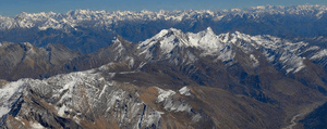 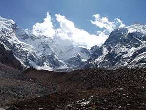 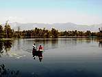 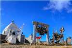 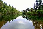 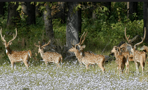 From Top left to right Saipal, Api Himal, Ghodaghodi Lake, Badimalika Temple, Khaptad Lake and Swamp deer at Shuklaphanta National Park | |
 Seal | |
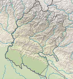
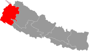 Location of Sudurpashchim Pradesh | |
| Coordinates: 28°42′12″N 80°34′01″E | |
| Country | |
| Formation | 20 September 2015 |
| Capital | Godawari |
| Largest city | Dhangadhi |
| Districts | 9 |
| Government | |
| • Body | Government of Sudurpashchim Pradesh |
| • Governor | Sharmila Kumari Panta |
| • Chief Minister | Trilochan Bhatta (NCP) |
| • High Court | Dipayal High Court |
| • Provincial Assembly | Unicameral (53 seats) |
| • Parliamentary constituency | 16 |
| Area | |
| • Total | 19,874 km2 (7,673 sq mi) |
| Area rank | 6th |
| Population (2011) | |
| • Total | 2,552,517 |
| • Rank | 5th |
| • Density | 130/km2 (330/sq mi) |
| • Density rank | 5th |
| Demonym(s) | Doteli/Sudur Pashchimeli |
| Time zone | UTC+5:45 (NST) |
| Geocode | NP-SE |
| Official language | Nepali |
| Other language(s) | 1. Doteli 2. Tharu |
| HDI | 0.478 (low) |
| Literacy | 63.48% |
| Sex ratio | 91.25 ♂ /100 ♀ (2011) |
| Website | p7 |
History
Doti was an ancient kingdom in far western region of Kumaon which was formed after the disintegration of the Katyuri Kingdom of Kumaon around the 13th century.[5] Doti was one of eight different princely states Katyuri Kingdom was divided into eight for their eight prince's and became different independent kingdoms; Baijnath-Katyuri, Dwarahat, Doti, Baramandal, Askot, Sira, Sora, Sui (Kali Kumaon). Later on, the whole land between Ramganga on the west (Uttarakhand) and the Karnali on the east (which divides the far western region from other parts Nepal), came under the Raikas after the origin of Raikas of Katyuris in Doti.[6] "Brahma Dev Mandi" at Kanchanpur District of Mahakali Zone was established by Katyuri king Brahma Dev.[7]
Before announcement of new provinces in Nepal, the area of this province was known as Far-Western development region of Nepal. There was no changes made in this province when this province was made.
Raikas of Doti
Niranjan Malla Dev was the founder of Doti Kingdom around the 13th century after the fall of the Katyuri Kingdom. He was the son of Last Katyuris of united Katyuris kingdom.[8]
Kings of Doti were called Raikas (also Rainka Maharaj).[9] Later on Raikas, after defeating the Khas Malla of Karnali Zone, were able to establish a strong Raikas Kingdom in Far Western Region and Kumaon which was Doti.
Mughal invasion
During the period of Akbar's rule in the 16th century, the Mughals had attacked the Raikas of Doti. They invaded Ajemeru, capital of the Raika Kingdom. Ajemeru is now in Dadeldhura District of far western region of Nepal. Hussain Khan, army chief of Akbar residing in Lucknow had led the attack. According to `Abd al-Qadir Bada'uni (c. 1540 - 1615), Indo-Persian historian during Mughal Empire, Mughal Army chief of Lukhnow, Hussian Khan, lured by the wealth and treasures of the kingdom of the Raikas, wanted to plunder the state, this being the motive behind the assault; but they did not succeed.[10]
Conflict with Gorkha
The historic place of war between the Doti Kingdom and Nepal (Gorkha kingdom) during the period of Gorkha Expansion in 1790, according to the history of Nepal, is Nari-Dang, on the bank of the Seti River. The Dumrakot was the base of Doti Kingdom for fighting against the Gorkhalis.
Khairgarh-Singhai State
Raja Deep Shahi was expelled from Nepal in 1790 A.D and on arriving to Terai of Oudh (now Lakhimpur Kheri District of Uttar Pradesh of India) he established Khairgarh-Singhai State in Khairigarh under British India.[11] Kanchanpur Praganna (present Kanchanpur and Kailali districts) was also the parts of his State or Zamindari. He succeeded in defeating the Banjaras rural of Khairigarh and establishing himself not only in that Pargana but also in parts of Bhur. His state was merged with India In 1947 after Indian Independence.
Government and administration
The Governor acts as the head of the province while the Chief Minister is the head of the provincial government. The Chief Judge of the Dipayal High Court is the head of the judiciary.[12] The present Governor, Chief Minister and Chief Judge are Mohan Raj Malla (governor), Trilochan Bhatta (chief minister) and Yagya Prasad Basyal.[13][14] The province has 53 provincial assembly constituencies and 16 House of Representative constituencies.[15]
Sudurpashchim Pradesh has a unicameral legislature, like all of the other provinces in Nepal. The term length of provincial assembly is five years. The Provincial Assembly of Sudurpashchim Pradesh is temporarily housed at the District Coordination Committee Hall in Dhangadhi.[16]
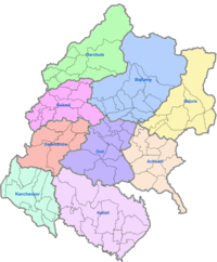
Administrative subdivisions
The province is divided into nine districts, which are listed below. A district is administrated by the head of the District Coordination Committee and the District Administration Officer. The districts are further dived to municipalities or rural municipalities. The municipalities include one sub-metropolitan city and 33 municipalities. There are 54 rural municipalities in the province.[17]
Demographics
Religion in Sudurpashchim Pradesh
The province has a population of 2,552,517 which is 9.63% of the total population of Nepal. The population density is about 130 persons per square kilometre. The province has a population growth rate of 1.53%. The sex ratio is 912 males for 1000 females, with a total of 1,217,887 males and 1,334,630 females recorded in 2011. The urban population of the region is 1,504,279 (58.9%) and the rural population is 1,048,238 (41.1%).[18]
See also
- List of provinces of Nepal
- List of districts of Nepal
References
- "Nepal Provinces". statoids.com. Retrieved 21 March 2016.
- "Prov 7 named Sudurpaschim amid objection from NC, RJP". The Himalayan Times. 28 September 2018. Retrieved 1 October 2018.
- "Province 7 named Sudurpashchim, Godawari capital". The Kathmandu Post. 28 September 2018. Retrieved 1 October 2018.
- "Nepal Provinces". www.statoids.com.
- Dr.Y.S Kathoch, A New History of Uttarakhand; On Katyuri Dynasty "Around,13th Century Katyuri Dynasty established in Ranachulihat was broken into many sections" Doti was among them
- Advin T. Atkinson; Gazetteer Hindi Edition (2003); He wrote (Page 274) Whole territory to the east of Ram gang was belongs to Raikas during the late 16th century.
- Dr. Madam Chandra Bhatt; A New History of Uttarakhand (2006): " Champawat ke Chand Raja.
- Dr. Y.S Kathoch; A New History of Uttarakhand(2006).Founder of Doti was Niranjan Mall Dev..
- Badri Datt Pandey ; History of Kumaun (1937)
- "Kumaon History". Thekumaonhills.com. 29 March 1947. Retrieved 4 June 2015.
- "High Courts get their chief judges". Retrieved 27 April 2018.
- "Trilochan Bhatta becomes Province 7 chief minister". The Himalayan Times. 16 February 2018. Retrieved 28 April 2018.
- "President of Nepal administers oath to Chiefs of seven provinces | DD News". ddnews.gov.in. Retrieved 27 April 2018.
- "CDC creates 495 constituencies". The Himalayan Times. 31 August 2017. Retrieved 27 April 2018.
- "Preparations under way for assembly meeting". The Himalayan Times. 31 January 2018. Retrieved 28 April 2018.
- "स्थानिय तह". 103.69.124.141. Retrieved 27 April 2018.
- "Nepal Census 2011" (PDF). UN Stats.
Places adjacent to Sudurpashchim Pradesh | ||||||||||
|---|---|---|---|---|---|---|---|---|---|---|
| ||||||||||