Myagdi District
Myagdi District (Nepali: म्याग्दी जिल्ला ![]()
Myagdi District (म्यग्दी जिल्ला)
| |
|---|---|
District | |
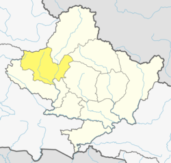 Location of Myagdi (dark yellow) in Gandaki Pradesh | |
| Country | |
| Province | Gandaki Pradesh |
| Admin HQ. | Beni |
| Government | |
| • Type | Coordination committee |
| • Body | DCC, Myagdi |
| Area | |
| • Total | 2,297 km2 (887 sq mi) |
| Population (2011) | |
| • Total | 113,641 |
| • Density | 49/km2 (130/sq mi) |
| Time zone | UTC+05:45 (NPT) |
| Telephone Code | 069 |
Geography and Climate
This district can experience 7 types of climates
| Climate Zone[2]
i |
Elevation Range | % of Area |
|---|---|---|
| Upper Tropical | 300 to 1,000 meters 1,000 to 3,300 ft. |
0.1% |
| Subtropical | 1,000 to 2,000 meters 3,300 to 6,600 ft. |
17.5% |
| Temperate | 2,000 to 3,000 meters 6,400 to 9,800 ft. |
28.0% |
| Subalpine | 3,000 to 4,000 meters 9,800 to 13,100 ft. |
21.1% |
| Alpine | 4,000 to 5,000 meters 13,100 to 16,400 ft. |
17.8% |
| Nival | above 5,000 meters | 13.9% |
| Trans-Himalayan | 3,000 to 6,400 meters 9,800 to 21,000 ft. |
1.6% |
Demographics
At the time of the 2011 Nepal census, Myagdi District had a population of 113,641. Of these, 94.2% spoke Nepali, 2.2% Magar, 1.0% Kham, 0.9% Chhantyal and 0.6% Newari as their first language.[3]
Administration
The district consists of 6 Municipalities, out of which one is an urban municipality and five are rural municipalities. These are as follows:[4]
- Beni Municipality
- Annapurna Rural Municipality
- Dhaulagiri Rural Municipality
- Mangala Rural Municipality
- Malika Rural Municipality
- Raghuganga Rural Municipality
Former Village Development Committees
Prior to the restructuring of the district, Myagdi District consisted of the following municipalities and Village development committees:
- Arman
- Arthunge
- Baadook
- Babiyachaur
- Baranja
- Begkhola
- Beni Municipality
- Bhakilmi
- Bhanbare
- Bima
- Chimkhola
- Dagnam
- Dana
- Darwang
- Devisthan
- Doba
- Ghar
- Ghatan
- Gurja Khani
- Histhan Mandali
- Jhin
- Jyamrukot
- Khibang
- Kuhunkot
- Kuinemangale
- Lulang
- Malkwang
- Marang
- Mudi
- Muna
- Nangi
- Narchyang
- Niskot
- Okharbot
- Pakhapani
- Patlekhet
- Pulachaur
- Rakhu Bhagawati
- Rakhupiple
- Ramche
- Ratnechaur
- Shikha
- Singa
- Takam
- Tatopani
- Ruma
Tourism
Myagdi district is one of the most popular destination for Tourism. The world famous Poon Hill lies in the Ghara VDC of this district. Ghorepani is another attraction for travelers. The trekking/hiking trail Ghorepani Poon Hill Trek is considered as easy and most liked trail in Annapurna region. The flora and fauna of this district is unique. Not only in natural resources, it is rich in cultural heritage. Magars specially Pun community are welcoming the foreigners with their smile for long time. Tatopani Hot Spring is another attraction of Myagdi.
Ghorepani village is beautiful settlement and well managed lodges are available for Annapurna View trekking. The newly opened Karbakeli Eco Trek Explore is another destination for hikers.
Mohare Hill of Ramche of Myagdi district another destination for hiker. Mohare hill is located at 3000 meters from the sea level . Annapurna dhaulagiri mountain range can be observe from Mohare hill.[5]
Famous people
- Min Bahadur Sherchan, who was the oldest man to summit Mount Everest for about 5 years, was born in Myagdi district of Nepal was born here.[6]
- Nirmal Purja MBE, a mountaineer and former Gurkha and Special Boat Service (SBS) soldier.
See also
- Zones of Nepal
References
- "National Population and Housing Census 2011 (National Report)" (PDF). Central Bureau of Statistics. Archived from the original (PDF) on 2013-05-25. Retrieved November 2012. Check date values in:
|accessdate=(help) - The Map of Potential Vegetation of Nepal - a forestry/agroecological/biodiversity classification system (PDF), Forest & Landscape Development and Environment Series 2-2005 and CFC-TIS Document Series No.110., 2005, ISBN 87-7903-210-9, retrieved Nov 22, 2013
- 2011 Nepal Census, Social Characteristics Tables
- "स्थानिय तह" (in Nepali). Ministry of Federal Affairs and General Administration. Archived from the original on 31 August 2018. Retrieved 1 September 2018.
- "Mohare Hill Trek | The Complete Beginners Guide to Mohare Danda Trekking Myagdi Nepal - Prasant Bhatt". Prasant Bhatt. 2018-08-08. Retrieved 2018-08-10.
- "Nepal's 86yo climber announces to attempt Everest again". The Himalayan Times. 2017-03-06. Retrieved 2018-07-12.
- "Districts of Nepal". Statoids.
Headquarters: Beni Municipality | ||
| Municipalities |
|  |
| Rural municipalities |
| |
| Former VDCs |
| |
| Wikimedia Commons has media related to Myagdi District. |