Jhapa District
Jhapa (Nepali: झापा जिल्ला![]()
Jhapa District झापा जिल्ला | |
|---|---|
District | |
 Beautiful hill and river view,Jhapa | |
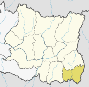 | |
.png) Administrative divisions of Jhapa | |
| Country | |
| Province | Province No. 1 |
| Admin HQ. | Bhadrapur |
| Government | |
| • Type | Coordination committee |
| • Body | DCC, Jhapa |
| • Head | Mr. Somnath Bishwakarma |
| • Deputy-Head | Mrs. Mina Parajuli |
| • Parliamentary constituencies | 5 |
| • Provincial constituencies | 10 |
| Area | |
| • Total | 1,606 km2 (620 sq mi) |
| Elevation (maximum) | 506 m (1,660 ft) |
| Population (2011[1]) | |
| • Total | 812,650 |
| • Density | 510/km2 (1,300/sq mi) |
| Time zone | UTC+05:45 (NPT) |
| Website | www.ddcjhapa.gov.np |
Location
Jhapa is the easternmost district of Nepal and lies in the fertile Terai plains. It is part of the Outer Terai. Jhapa borders with Ilam in the north, Morang in the west, the Indian state of Bihar in the south and the Indian state of West Bengal to the southeast and east. Geographically, it covers an area of 1,606 km2 (620 sq mi) and lies on 87º39’ east to 88º12’ east longitude and 26º20’ north to 26º50’ north latitude.[3]
Climate and Geography
Jhapa receives 250 to 300 cm of rainfall a year, and mostly during the monsoon season in the summer, and its hilly northern area receives more rainfall than the south.[4] The maximum temperature is recorded 42 °C in summer and 10 °C in winter. The lowest elevation point is 58 meter which is the lowest land of Nepal and highest elevation point is 500 meter from mean sea level of the district.[5]
| Climate Zone[6] | Elevation Range | % of Area |
|---|---|---|
| Lower Tropical | below 300 meters (1,000 ft) | 98.8% |
| Upper Tropical | 300 to 1,000 meters 1,000 to 3,300 ft. |
1.2% |
Air Quality
Air quality of Jhapa is fairly moderate, but worsens in dry seasons due to pollution from business hubs like Birtamod and Damak. However, in monsoon seasons, the quality is usually moderate to good.
Economy
Jhapa's economy has heavily relied on agriculture for past some decades. However, after the 1990s, industrialization has occurred. Due to the rapid growth of business hubs like Birtamode, urban businesses are booming. Agriculture continues in the rural surroundings.
Business
In Jhapa, numerous manufacturing companies produce tons of exportable products.
Some major exports of Jhapa are:
- Tea
Jhapa is the largest producer of tea in Nepal. There are many tea-processing businesses in Jhapa.
- Cement
Cement manufacturing is another one of the most important business. Mansa Cement is an example.
- Other manufacturing business
Jhapa houses many small manufacturing businesses that produce exportable goods such as grills, alumunium, and copper.
- Other Agricultural Business
Rural Jhapa still relies on agricultural productions and business. Jhapa is the top paddy producer of Nepal followed by Morang. Due to Jhapa's fertile land, other cash crops like banana, coconuts and betel nuts (supari) is feasible and also exported to India.
Remittance
As elsewhere in Nepal, Jhapa relies on remittances from youth working abroad.
Tourism
Despite of having fewer tourism sites than neighboring districts such as Ilam, Jhapa has some touristic appeal. Starting point of eastern tourism epicenters like Ilam, Antu, Taplejung is centered in Jhapa. Youths work as taxi drivers as the narrow two-lane Mechi highway is not considered safe for buses.
Administrative Division
Jhapa consists of 15 administrative divisions including 8 municipalities and 7 rural municipalities. Each divisions have wards according to the demographic and geographic size. These are:
Municipalities
Demographics
Jhapa district has average population density of around 428.4 per square kilometer. The district population growth rate is 1.84%. However, the growth is balanced and in-migration is rapidly increasing day to day from rural area to in this district. At the time of the 2011 Nepal census, Jhapa District had a population of 812,650. Of these, 55.8% spoke Nepali, 10.3% Rajbanshi, 5.6% Limbu, 5.5% Maithili, 3.6% Santali, 2.5%Rai 2.4% Hindi, 2.1% Tamang, 1.5% Tajpuriya, 1.5% Newari, 1.3% Magar, 1.0% Dhimal, 0.8% Tharu, 0.7% Bengali, 0.6% Gurung and 0.5% Mech as their first language.
35.0% of the population in the district spoke Nepali, 1.6% Rajbanshi[7]
International Borders
Jhapa borders to India in east and south. Jhapa is an eastern entry point of Nepal from India. Famous Kakarbhitta border lies here and is an important trade point of Nepal.
Education
Among 77 districts, Jhapa has a literacy rate of 95.2%, the highest of any district.[8] There are enough primary schools, secondary schools, high schools and colleges available both from private sector and the government.
Healthcare and Hospitals
Healthcare of Jhapa is considered good. There are enough hospitals in towns and medical facility is available on all municipalities and rural-municipalities. Specialized hospitals like cancer hospital in Birtamod and snake-bite treatment hospital in Charali are also available. Jhapa also houses some of the best eye hospitals in Nepal. Eye patients from Bangladesh and India are observed alot.
Infrastructures
Infrastructural development in Jhapa took its pace in the last decades. Infrastructures of Jhapa are considered some of the best in nation. Every towns, villages and cities are connected via road network and there is no town or village without the reach of electricity and Internet.
Transportation

Transportation options are pretty common in Jhapa and no different from the rest of the nation. There's an airport in district capital Bhadrapur. Bus service and e-cabs (safari) are available all around Jhapa. Because of the wide road network, commuting around Jhapa in the bus is easy and affordable. High-speed bus service is available on major highways to commute through various highway-side towns like Itabhatta, Dhulabari and cities like Birtamod and Damak. Red-colored buses are high-speed buses and green-colored buses perform inter-district, high-speed transportation.
Road Network
Jhapa's road network is dense, given its size. Every tole, chowk, municipality, town, and city is connected via road. Two major highways originate in Jhapa. Mahendra Highway H01 from downtown Kakarbhitta, which crosses whole country, and Mechi Highway H07 from district capital Bhadrapur, which reaches Taplejung. Feeder roads Birtamode to Bhadrapur F001 and Padajungi to Gauriganj lie here. There are also plenty of district roads and urban roads in Jhapa.
There are several feeder and district road junctions and there is one major highway junction which is Charali junction where H01 and H07 cross each other.
References
- Household and population by districts, Central Bureau of Statistics (CBS) Nepal Archived 2013-07-31 at the Wayback Machine
- "Seven places to visit while you're in Jhapa". kathmandupost.com. Retrieved 2019-12-14.
Jhapa might just be the most diverse of Nepal’s districts. Out of the total 126 castes/ethnic groups across the country, Jhapa is home to 110 ethnic groups, including the endangered Santhal and Ganesh (Gangai) tribes.
- District Transport Masterplan-Jhapa (PDF), retrieved May 5, 2020
- Climate in Jhapa, retrieved May 5, 2020
- District Transport Masterplan-Jhapa (PDF), retrieved May 5, 2020
- The Map of Potential Vegetation of Nepal - a forestry/agroecological/biodiversity classification system (PDF), Forest & Landscape Development and Environment Series 2-2005 and CFC-TIS Document Series No.110., 2005, ISBN 87-7903-210-9, retrieved Nov 22, 2013
- https://cbs.gov.np/wp-content/upLoads/2018/12/Volume05Part02.pdf 2011 Nepal Census, Social Characteristics Tables
- "Census 2001". Census. central bureau of statistics, Nepal. 2001. Archived from the original on 2008-09-24. Retrieved 2008-08-24.
Places adjacent to Jhapa District | ||||||||||
|---|---|---|---|---|---|---|---|---|---|---|
| ||||||||||
Headquarter: Bhadrapur | ||
| Rural Municipalities | | |
| Municipalities |
| |
External links
- "Districts of Nepal". Statoids.
| Wikimedia Commons has media related to Jhapa District. |