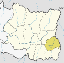
Ilam District
Ilam district (Nepali: इलाम जिल्ला![]()
Ilam District इलाम जिल्ला | |
|---|---|
District | |
.jpg) Lush Green Tea Gardens are what makes Ilam district popular. | |
 | |
 | |
| Country | |
| Province | Province No. 1 |
| Admin HQ. | Ilam |
| Government | |
| • Type | Coordination committee |
| • Body | DCC, Ilam |
| • Head | Mr. Ganesh Prasad Baral |
| • Deputy-Head | Mrs. Chitrakala Baraili |
| • Parliamentary constituencies | 2 |
| • Provincial constituencies | 4 |
| Area | |
| • Total | 1,703 km2 (658 sq mi) |
| Highest elevation | 3,636 m (11,929 ft) |
| Population (2011[1]) | |
| • Total | 290,254 |
| • Density | 170/km2 (440/sq mi) |
| Time zone | UTC+05:45 (NPT) |
| Main Language(s) | Lepcha language, Nepali, Rai, Limbu |
| Website | www.ddcilam.gov.np |
Introduction

Ilam attracts many researchers who come to study rare birds and the red panda. Ilam stretches from the Terai belt to the upper hilly belt of this Himalayan nation.
The name Ilam is derived from the limbu language in which "IL" means twisted and "Lam" means road. Ilam was one of the ten self ruling states of Limbuwan before the reunification of Nepal. Its ruler King Hangshu Phuba Lingdom of Lingdom dynasty ruled Ilam as a confederate state of Limbuwan until 1813 AD. The treaty between the other Limbuwan states and the King of Gorkha (Gorkha-Limbuwan Treaty of 1774 AD) and the conflict of Gorkha and Sikkim led to the unification of Ilam with Gorkha. Ilam was the last of the ten kingdoms of Limbuwan to be reunified into Nepal. The King of Gorkha gave the ruler of Ilam full autonomy to rule and the right of Kipat. Ilam was an independent Limbu kingdom until 1813 CE/1869 BS.
Ilam is today one of the most developed places in Nepal. Its ILAM TEA is very famous and is exported to many parts of Europe. The main source of income in this district is tea, cardamom, milk, ginger, potato, orlon, and broom production on a large scale.
This place also has a religious importance. The devi temples have a great importance attached to them and many people come here just for pilgrimage.
The major attraction of Ilam is the nine-cornered Mai Pokhari lake. Also known as the abode of the goddess many tourists as well as Nepalese people come to visit this place. Similarly, Gajurmukhi is also the religious spot for pilgrimages from Nepal and India. Mai river and its four tributaries also emerge in Ilam district. The famous Mane Bhanjyang (Mane pass) connects Ilam with Darjeeling district of West Bengal, India.
.jpg)
Ilam was much in the news in the past during the Maoist insurgency, from here the Maoists launched frequent, massive attacks.
Tourists going to Ilam can expect to pay around 7000 rupees a week for accommodation and food.
Geography and climate
| Climate Zone[2] | Elevation Range | % of Area |
|---|---|---|
| Lower Tropical | below 300 meters (1,000 ft) | 15.5% |
| Upper Tropical | 300 to 1,000 meters 1,000 to 3,300 ft. |
33.5% |
| Subtropical | 1,000 to 2,000 meters 3,300 to 6,600 ft. |
40.1% |
| Temperate | 2,000 to 3,000 meters 6,400 to 9,800 ft. |
10.6% |
| Subalpine | 3,000 to 4,000 meters 9,800 to 13,100 ft. |
0.3% |
Demographics
At the time of the 2011 Nepal census, Ilam District had a population of 290,254. Of these, 42.8% spoke Nepali, 14.3% Limbu, 8.3% Bantawa, 8.3% Rai , 6.0% Tamang, 4.6% Magar, 2.1% Gurung, 2.1% Newari, 1.2% Sherpa, 1.0% Chamling, 1.0% Sunuwar, 0.9% Lepcha, 0.6% Kulung, 0.5% Yakkha and 0.5% Sampang as their first language.
45.7% of the population in the district spoke Nepali, 1.5% Rai, 1.4% Bantawa, 1.3% Limbu and 0.5% English as their second language.[3]
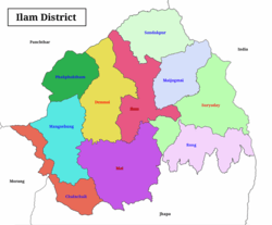
Divisions
Ilam is divided into 4 urban and 6 rural municipalities.
| No. | Type | Name | Nepali | Population (2011) | Area | Website |
|---|---|---|---|---|---|---|
| 1 | Urban | Ilam | इलाम | 48536 | 173.32 | |
| 2 | Urban | Deumai | देउमाई | 32927 | 191.63 | |
| 3 | Urban | Mai Municipality | माई | 32576 | 246.11 | |
| 4 | Urban | Suryodaya | सूर्योदय | 56691 | 252.52 | |
| 5 | Rural | Phakphokthum | फाकफोकथुम | 21,619 | 108.79 | |
| 6 | Rural | Mai Jogmai | माईजोगमाई | 21,044 | 172.41 | |
| 7 | Rural | Chulachuli | चुलाचुली | 20,820 | 108.46 | |
| 8 | Rural | Rong | रोङ | 19,135 | 155.06 | |
| 9 | Rural | Mangsebung | माङसेबुङ | 18,503 | 142.41 | |
| 10 | Rural | Sandakpur | सन्दकपुर | 16,065 | 156.01 | |
| District | Ilam | ईलाम |
Former Village Development Committees and Municipalities

- Amchok
- Banjho
- Barbote
- Chamaita
- Chisapani
- Chulachuli
- Danabari
- Deumai Municipality
- Dhuseni (now Deumai Municipality)
- Ibhang
- Ektappa
- Erautar
- Gajurmukhi
- Ghuseni
- Godak
- Gorkhe
- Jamuna
- Ilam Municipality
- Jirmale
- Jitpur
- Jogmai
- Kolbung
- Lakshmipur
- Lumde
- Mabu
- Mahamai
- Maimajhuwa
- Maipokhari
- Mangalbare (now Deumai Municipality)
- Namsaling
- Naya Bazar
- Pashupatinagar
- Phakphok
- Phuyatappa
- Puwamajhuwa
- Pyang
- Sakphara
- Sakhejung
- Samalbung
- Sangrumba
- Shanti Danda
- Shantipur
- Siddhithumka
- Soyak
- Soyang
- Shree Antu
- Sulubung
- Sumbek
- Suryodaya Municipality
See also
- Zones of Nepal
- danabari
References
- "National Population and Housing Census 2011(National Report)" (PDF). Central Bureau of Statistics. Government of Nepal. November 2012. Archived from the original (PDF) on 2013-04-18. Retrieved November 2012. Check date values in:
|accessdate=(help) - The Map of Potential Vegetation of Nepal - a forestry/agroecological/biodiversity classification system (PDF), . Forest & Landscape Development and Environment Series 2-2005 and CFC-TIS Document Series No.110., 2005, ISBN 87-7903-210-9, retrieved Nov 22, 2013
- 2011 Nepal Census, Social Characteristics Tables
External links
| Wikimedia Commons has media related to Ilam District. |
- "Districts of Nepal". Statoids.
Places adjacent to Ilam District | |
|---|---|
Headquarter: Ilam | ||
| Rural Municipalities | | |
| Municipalities | ||