Storm Mountain (Alberta)
Storm Mountain is a mountain in Alberta's Rockies, Canada.
| Storm Mountain | |
|---|---|
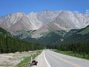 Storm Mountain from Kananaskis Trail | |
| Highest point | |
| Elevation | 3,095 m (10,154 ft) [1] |
| Prominence | 291 m (955 ft) [2] |
| Coordinates | 50.5844°N 114.9405°W |
| Geography | |
| Location | Alberta, Canada |
| Parent range | Misty Range |
| Topo map | NTS 82J/10 |
| Climbing | |
| Easiest route | Scramble |
It is located alongside Highway 40, southwest of the Highwood Pass parking lot in Kananaskis Country, and is part of the Misty Range of the Canadian Rockies. It is identifiable as the tall peak between Mount Arethusa and Mist Mountain at the far south end of the Misty Range.
It was named by George Mercer Dawson in 1884, for the storm clouds he saw on the summit.[1]
The "other" Storm Mountain
Dawson also named another peak Storm Mountain, 100 km away on the continental divide that separates Alberta and British Columbia, and Banff National Park and Kootenay National Park, to the northwest. It is unusual for two peaks of such close proximity to share the same name, especially when named by the same individual.
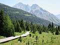
Gallery
 Storm Mountain from Highwood Pass
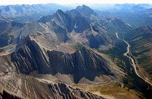 Arethusa, Storm, and Mist Mountain from the north
.jpg) Storm Mountain from Highwood Pass area
Storm Mountain from Highwood Pass area
References
- "Storm Mountain". PeakFinder.com. Retrieved 2007-09-03.
- "Storm Mountain". Bivouac.com. Retrieved 2009-01-02.
External links
- Storm Mountain photo: Flickr
- Storm Mountain weather: Mountain Forecast
This article is issued from Wikipedia. The text is licensed under Creative Commons - Attribution - Sharealike. Additional terms may apply for the media files.