Mist Mountain
Mist Mountain is a mountain located alongside Highway 40 in the Canadian Rockies of Alberta, Canada.
| Mist Mountain | |
|---|---|
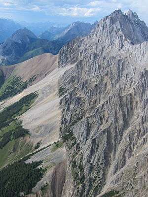 Mist Mountain from the south | |
| Highest point | |
| Elevation | 3,140 m (10,300 ft) [1] |
| Prominence | 487 m (1,598 ft) [2] |
| Coordinates | 50.55416°N 114.90957°W [2] |
| Geography | |
| Location | Alberta, Canada |
| Parent range | Misty Range |
| Topo map | NTS 82J/10 |
| Climbing | |
| First ascent | 1946, Donald King, Alan Blayney, Len Blayney, York Blayney[1] |
| Easiest route | Hike, but avoid 'nameless ridge' |
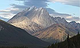
It reaches an elevation of 3,140 m (10,300 ft) and is visible from Alberta Highway 40 and the Sheep River.
The mountain was named in 1884 by George M. Dawson.[2]
Mist Mountain is composed of sedimentary rock that was pushed east and over the top of younger rock during the Laramide orogeny.[3]
Climate
Based on the Köppen climate classification, Mist Mountain is located in a subarctic climate with cold, snowy winters, and mild summers.[4] Temperatures can drop below −20 °C with wind chill factors below −30 °C.
In terms of favorable weather, June through September are the best months to climb Mist Mountain.
Precipitation runoff from the mountain drains into tributaries of the Highwood River.
See also
References
- Mist Mountain PeakFinder
- "Mist Mountain". Bivouac.com. Retrieved 2009-01-02.
- Gadd, Ben (2008). "Geology of the Rocky Mountains and Columbias". Cite journal requires
|journal=(help) - Peel, M. C.; Finlayson, B. L. & McMahon, T. A. (2007). "Updated world map of the Köppen−Geiger climate classification". Hydrol. Earth Syst. Sci. 11: 1633–1644. ISSN 1027-5606.
External links
- Mist Mountain on www.peakware.com
- Mist Mountain weather: Mountain Forecast