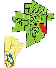
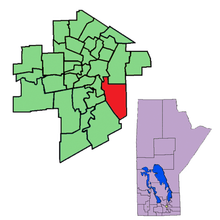
Southdale (electoral district)
Southdale is a provincial electoral division in the Canadian province of Manitoba. It was created in the provincial redistribution 1999, mostly out of Niakwa and part of St. Vital. The riding is located in the southeastern section of the City of Winnipeg.
 | |||
| Provincial electoral district | |||
| Legislature | Legislative Assembly of Manitoba | ||
| MLA |
Progressive Conservative | ||
| District created | 1998 | ||
| First contested | 1999 | ||
| Last contested | 2019 | ||
Southdale is bordered on the east by the rural ridings of La Verendrye and Springfield, to the south by Seine River, to the north by Radisson and St. Boniface, and to the west by Riel and St. Vital.
The riding's population in 1996 was 19,029. Its character is mostly middle class. In 1999, the average family income was $68,944, and the unemployment rate was 5.00%. Twelve per cent of Southdale's residents are francophone. Health and social service work accounts for 14% of Southdale's industry.
From 2003 to 2007, Southdale was the only riding in southeastern Winnipeg to be represented by a Progressive Conservative, following historical breakthroughs by the New Democratic Party of Manitoba (NDP) in surrounding ridings in the 2003 provincial election. The NDP proceeded to oust incumbent MLA Jack Reimer in the 2007 provincial election, completing their sweep of Southeast Winnipeg. The seat remained NDP from 2007 until 2016 when it returned to the PCs.
Members of the Legislative Assembly
| Term of Office | Name | Political Party |
|---|---|---|
| 1999–2007 | Jack Reimer | Progressive Conservative |
| 2007–2016 | Erin Selby | New Democrats |
| 2016–2019 | Andrew Smith | Progressive Conservative |
| 2019–present | Audrey Gordon | Progressive Conservative |
Electoral results
| 2019 Manitoba general election | ||||||||
|---|---|---|---|---|---|---|---|---|
| Party | Candidate | Votes | % | ±% | Expenditures | |||
| Progressive Conservative | Audrey Gordon | 4,486 | ||||||
| New Democratic | Karen Myshkowsky | 3,955 | ||||||
| Liberal | Spencer Duncanson | 1,422 | ||||||
| Green | Katherine Quinton | 584 | ||||||
| Independent | Robert Cairns | 70 | ||||||
| Total valid votes | 100.0 | |||||||
| Total rejected ballots | ||||||||
| Turnout | ||||||||
| Eligible voters | ||||||||
| 2016 Manitoba general election | ||||||||
|---|---|---|---|---|---|---|---|---|
| Party | Candidate | Votes | % | ±% | Expenditures | |||
| Progressive Conservative | Andrew Smith | 6,663 | 63.82 | +18.83 | $43,062.01 | |||
| New Democratic | Dashi Zargani | 2,460 | 23.56 | -28.45 | $19,423.93 | |||
| Liberal | Ryan Colyer | 1,318 | 12.62 | +9.62 | $1,526.57 | |||
| Total valid votes/Expense limit | 10,441 | 97.78 | - | $53,274.00 | ||||
| Total rejected ballots | 237 | 2.22 | +1.90 | |||||
| Turnout | 10,678 | 62.31 | -7.82 | |||||
| Eligible voters | 17,137 | |||||||
| Progressive Conservative gain from New Democratic | Swing | +23.64 | ||||||
| Source: Elections Manitoba[1][2][3] | ||||||||
| 2011 Manitoba general election | ||||||||
|---|---|---|---|---|---|---|---|---|
| Party | Candidate | Votes | % | Expenditures | ||||
| New Democratic | Erin Selby | 5,662 | 51.84 | $29,012.79 | ||||
| Progressive Conservative | Judy Eastman | 4,898 | 44.85 | $36,267.68 | ||||
| Liberal | Amarjit Singh | 327 | 2.99 | $3,107.04 | ||||
| Total valid votes/Expense limit | 10,887 | 100.00 | $43,733.00 | |||||
| Total rejected ballots | 35 | 0.41 | ||||||
| Turnout | 10,922 | 70.13 | +4.39 | |||||
| Eligible voters | 15,574 | |||||||
| New Democratic hold | Swing | -2.96 | ||||||
| Source: Elections Manitoba[4] | ||||||||
| 2007 Manitoba general election | ||||||||
|---|---|---|---|---|---|---|---|---|
| Party | Candidate | Votes | % | Expenditures | ||||
| New Democratic | Erin Selby | 5,772 | 51.04 | $30,198.49 | ||||
| Progressive Conservative | Jack Reimer | 4,493 | 39.74 | $31,445.97 | ||||
| Liberal | Don Woodstock | 1,042 | 9.22 | $4,974.42 | ||||
| Total valid votes/Expense limit | 11,307 | 100.00 | ||||||
| Total rejected ballots | 44 | |||||||
| Turnout | 11,351 | 65.74 | +9.78 | |||||
| Eligible voters | 17,267 | |||||||
| New Democratic gain | Swing | +13.32% | ||||||
| 2003 Manitoba general election | ||||||||
|---|---|---|---|---|---|---|---|---|
| Party | Candidate | Votes | % | ±% | Expenditures | |||
| Progressive Conservative | Jack Reimer | 4,422 | 51.03 | -0.13 | $16,203.32 | |||
| New Democratic | Carolyn Frost | 3,123 | 36.05 | +8.77 | $4,844.51 | |||
| Liberal | Chuck Mrena | 1,120 | 12.93 | -6.43 | $5,828.49 | |||
| Total valid votes/Expense limit | 8,665 | 100.00 | ||||||
| Total rejected ballots | 27 | |||||||
| Turnout | 8,692 | 55.96 | -18.60 | |||||
| Eligible voters | 15,533 | |||||||
| Progressive Conservative hold | Swing | -4.45% | ||||||
| 1999 Manitoba general election | ||||||||
|---|---|---|---|---|---|---|---|---|
| Party | Candidate | Votes | % | Expenditures | ||||
| Progressive Conservative | Jack Reimer | 5,455 | 51.16 | $25,319.24 | ||||
| New Democratic | Iris Taylor | 2,909 | 27.28 | $1,907.00 | ||||
| Liberal | Shirley Chaput | 2,064 | 19.36 | $10,349.79 | ||||
| Manitoba Party | Paul Gibson | 200 | 1.88 | $1,067.54 | ||||
| Total valid votes/Expense limit | 10,618 | 100.00 | ||||||
| Total rejected ballots | 45 | |||||||
| Turnout | 10,663 | 74.56 | ||||||
| Eligible voters | 14,301 | |||||||
Previous boundaries
References
- "Candidates: 41st General Election". Elections Manitoba. 29 March 2016. Retrieved 31 March 2016.
- "41ST GENERAL ELECTION, APRIL 19, 2016 - OFFICIAL RESULTS". Elections Manitoba. 19 April 2016. Retrieved 18 November 2016.
- "Election Returns: 41st General Election". Elections Manitoba. 2016. Retrieved 7 September 2018.
- "Election Returns: 40th General Election". Elections Manitoba. 2011. Retrieved 7 September 2018.
- http://www.elections.mb.ca/en/Results/39_division_results/39_southdale_summary_results.html - 2007 Results
- http://www.elections.mb.ca/en/Results/38_division_results/38_southdale_summary_results.html - 2003 Results
- http://www.electionsmanitoba.ca/apps/results/37gen/pbp.asp?ED=40 - 1999 Results