Signal Hill, Calgary
Signal Hill is a community in Calgary, Alberta. It contains the residential neighbourhoods of Sienna Hills and Signal Ridge. It is bounded by Sarcee Trail to the east, 17th Ave to the north, Glenmore Trail to the south and the community of Springbank Hill to the west.
Signal Hill | |
|---|---|
Neighbourhood | |
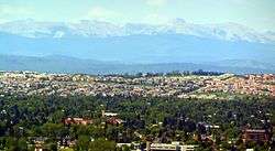 Signal Hill and Canadian Rockies | |
 Signal Hill Location in Calgary | |
| Coordinates: 51°01′50″N 114°10′29″W | |
| Country | |
| Province | |
| City | |
| Quadrant | SW |
| Ward | 6 |
| Established | 1987 |
| Annexed | 1956 |
| Government | |
| • Mayor | Naheed Nenshi |
| • Administrative body | Calgary City Council |
| • Councillor | Jeffrey Davison |
| Elevation | 1,190 m (3,900 ft) |
| Population (2012)[2] | |
| • Total | 13,914 |
| • Average Income (2005) | $100,844 |
| Time zone | UTC-7 (MST) |
| Postal code | T3H |
| Area code(s) | +1-403 |
| Website | Signal Hill Community Association |
Battalion Park is established on the southern slopes of the hill and the shopping centres at Westhills Towne Centre, Signal Hill Centre, Westmarket Square and Signature Park Plaza serve the community. Located in the Signal Hill Centre area is a public library called Signal Hill, which serves the surrounding community.[3]
The land was annexed to the City of Calgary in 1956, and Signal Hill was established in 1986. It is represented in the Calgary City Council by the Ward 6 councillor Jeff Davison,[1] on a provincial level by Calgary West MLA Mike Ellis, and at federal level by Calgary Signal Hill MP Ron Liepert.
Demographics
In the City of Calgary's 2012 municipal census, Signal Hill had a population of 13,914 living in 5,253 dwellings, a 0.9% increase from its 2011 population of 13,795.[2] With a land area of 5.6 km2 (2.2 sq mi), it had a population density of 2,485/km2 (6,440/sq mi) in 2012.[2][4]
Signal Hill is a wealthy neighbourhood, with the median household income of $205,844 (2013). The wealthier residents ($200,000-$400,000 median household income) live in Upper Signal hill, which is located on the top of the hill, above the first few rows of houses which are located above the famous Signal Hill numbers. The entrance to this area can be found along Signal Hill Drive.[5] As of 2006, 4% of the residents were immigrants.
Amenities
Battalion Park
Battalion Park, located on the hillside of Signal Hill, overlooks the Sarcee Nation. The area was a military reserve prior to World War I for the Canadian Forces. The hill features 16,000 stones hauled by soldiers and arranged to form four numbers (137, 113, 151 and 51). The numbers correspond to the four battalions of the Canadian Expeditionary Force who trained in that area before leaving to fight in World War 1. Battalion Park officially opened on November 3, 1991.[6]
Education
Signal Hill is home to the Battalion Park School. Operated by the Calgary Board of Education, the school serves students in kindergarten through grade six. In September 2012, it had an enrollment of 694 students drawn from Signal Hill and the nearby Richmond Hill and Springbank Hill communities.[7]
See also
References
- "Calgary Elections". City of Calgary. 2017. Retrieved November 12, 2017.
- "2012 Civic Census Results" (PDF). City of Calgary. 2012. Retrieved February 4, 2013.
- Signal Hill Community Association. "Signal Hill". Retrieved 2007-04-30.
- "Community Boundaries" (Esri shapefile). City of Calgary. Retrieved February 5, 2013.
- City of Calgary (2010). "Signal Hill Community Statistics" (PDF). Retrieved 2010-07-26.
- "Battalion Park". City of Calgary. Retrieved February 17, 2013.
- "School Profiles: Battalion Park School". Calgary Board of Education. Retrieved February 17, 2013.
External links
Places adjacent to Signal Hill, Calgary | ||||||||||
|---|---|---|---|---|---|---|---|---|---|---|
| ||||||||||