Hounsfield Heights/Briar Hill, Calgary
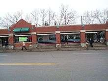
Hounsfield Heights/Briar Hill is an inner suburban neighbourhood in northwest Calgary, Alberta, Canada. Located north of the Hillhurst and West Hillhurst communities, the boundaries of the district are 16th Avenue N (Trans-Canada Highway)to the north; 14th Street W to the east; Lane north of 7th Avenue N to 19th Street W and 8th Avenue N to the south; and Crowchild Trail, 12th Avenue N, Juniper Road, and 22nd Street W to the west. Lions Park C-Train station is located within the community. The community is built on an escarpment and is popular for its views of downtown to the south and the Rocky Mountains to the west.
Hounsfield Heights/Briar Hill | |
|---|---|
Neighbourhood | |
 Location of Hounsfield Heights/Briar Hill in Calgary | |
| Coordinates: 51°03′54″N 114°06′12″W | |
| Country | |
| Province | |
| City | |
| Quadrant | NW |
| Ward | 7 |
| Established | 1953 |
| Annexed | 1906 |
| Government | |
| • Mayor | Naheed Nenshi |
| • Administrative body | Calgary City Council |
| • Councillor | Druh Farrell |
| Area | |
| • Total | 1.3 km2 (0.5 sq mi) |
| Elevation | 1,090 m (3,580 ft) |
| Population (2006)[2] | |
| • Total | 2,903 |
| • Average Income | $59,502 |
| Website | Hounsfield Heights/Briar Hill Community Association |
The community was annexed by the city of Calgary in 1906, and it was established as a neighbourhood in 1953.
Demographics
In the City of Calgary's 2012 municipal census, Hounsfield Heights/Briar Hill had a population of 2,954 living in 1,109 dwellings, a 0.9% increase from its 2011 population of 2,927.[3] With a land area of 1.2 km2 (0.46 sq mi), it had a population density of 2,460/km2 (6,380/sq mi) in 2012.[4][3]
Residents in this community had a median household income of $59,502 in 2000, and there were 7.8% low income residents living in the neighbourhood.[5] As of 2000, 15.1% of the residents were immigrants. A proportion of 21.5% of the buildings were condominiums or apartments, and 21.6% of the housing was used for renting.[2]
Education
In 2006, there was one school in the district:
- Briar Hill Elementary School - Public
See also
References
- "Calgary Elections". City of Calgary. 2017. Retrieved November 12, 2017.
- City of Calgary (2006). "Hounsfield Heights/Briar Hill Community Statistics" (PDF). Archived from the original (PDF) on 2007-09-30. Retrieved 2007-05-19.
- "2012 Civic Census Results" (PDF). City of Calgary. 2012. Retrieved February 4, 2013.
- "Community Boundaries" (Esri shapefile). City of Calgary. Retrieved February 5, 2013.
- City of Calgary (2004). "Ward 7 Profile" (PDF). Archived from the original (PDF) on 2007-08-09. Retrieved 2007-05-19.
External links
- Calgary Area. Hounsfield Heights-Briar Hill Community Info
Places adjacent to Hounsfield Heights/Briar Hill, Calgary | ||||||||||
|---|---|---|---|---|---|---|---|---|---|---|
| ||||||||||