Owhango
Owhango is a small town in New Zealand situated about 20 kilometres (12 mi) south of Taumarunui on State Highway 4 (SH4), and about 2 kilometres (1.2 mi) west of the Whakapapa River, a tributary of the nascent Whanganui River.

Ōwhango is a Māori name that translates as "the place of wheezy noises".[2]
The village features a backdrop of native forest and Mount Ruapehu, with native birds like tui and kereru. The domain, set amongst native forest, includes large open playing fields, children's play area and two tennis courts.[3]
The Main Trunk Line passes through Owhango on the western side of State Highway 4, with two crossing points for vehicles, one controlled (Owhango Road, centrally located) and the other uncontrolled (Onematua Road, on the northern boundary).
Geography
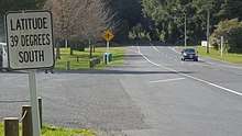
Owhango is located on the 39° latitude line, placing it on the boundary of the old Auckland Province and Wellington Province. [4]
Half way through Owhango is a sign marking "39° South". This sign is accurate (to within a few metres) when using NZ Geodetic Datum 1949.[5] The position of 39° South when using WGS84 (or NZ Geodetic Datum 2000) is about 196 metres further south, but this is not marked.[6]

The native forest is part of the Ohinetonga Scenic Reserve which contains unlogged old growth native forest containing some forest giants and a pretty lagoon accessible from a looped walking track. A road through the reserve, signposted from the State Highway, leads down to the view from the old logging bridge over the Whakapapa River. Along the river are memorable picnic spots with superb swimming pools containing rainbow and brown trout. It is also a launch point for kayakers heading for Kakahi, or even further down the Whanganui River.[7]
Beyond the bridge is the vast expanse of Tongariro Forest Conservation Area, once the source of timber for local mills, but now protected as conservation land thanks to a successful campaign in the 1980s led by local people to save the forest from clearance. Bisecting the forest is one of New Zealand's best mountain bike rides, the 42 Traverse. The forest also has excellent tramping, camping and deer hunting opportunities. In the heart of the regenerating forest is one of only a handful of national kiwi sanctuaries where the Department of Conservation controls alien predators to protect a population of the North Island Brown Kiwi.[8]
History
.JPG)
Owhango began as a mill town, milling native timbers from around the local area. The last operational mill burned to the ground in the 1970s. Many of the mill houses are now holiday homes owned by city dwellers keen on the skiing, fishing, hunting, canoeing and tramping opportunities that abound in the surrounding area. The village had a permanent population of 177 (2013 census data[9]) and has a primary school, garage (no fuel sold there, however), hotel, accommodation lodges, cottages for hire and bed and breakfast/homestay places and a café and public hall where the monthly market is held.[3]
There is an historical swimming pool actually constructed into the bed of the Kakahi Stream, located about 500 metres (1,600 ft) west down Onematua Road from State Highway 4 at the northern boundary of Owhango. The pool was created by locals in the hope of preparing one of the local athletes for the British Empire and Commonwealth Games. Beside the pool is a monument marking the centenary of the Treaty of Waitangi. Local records indicate the pool was first ready for use over the 1939/1940 summer. In 1961 a conventional swimming pool in the grounds of the local school was opened.[3]
The Owhango Hall was originally used as a silent movies cinema seating 250.[10] In more recent times it has mainly been used for community meetings and events, indoors bowls, and market days.[3]
The Owhango Volunteer Fire Brigade has been operating since 1965.[3]
Demographics
Owhango has a population of about 200, including people from Australia, South Africa, Germany, France, Canada, Austria, the Netherlands, England and other parts of New Zealand. Farming and tourism are the largest employers.[11]
Sports and events
The local sports teams generally dress in green and white. Historically, especially in the 1950s, the Owhango Domain played host to a sub-regional annual sports day..[3] It is still used for occasional sports and school events.[11]
The Owhango Hall is sometimes used for indoor bowls, and is also just big enough for one badminton court.[3]
Regular events at the domain and hall include the annual Owhango Pumpkin Growing Competition, monthly community markets, and an annual T42 mountain biking, running and walking event.[11]
Education
Owhango School is a co-educational state primary school for Year 1 to 8 students,[12][13] with a roll of 45 as of March 2020.[14]
The earliest schooling in Owhango was in canvas tents, starting from about 1904 and coinciding with the construction of the railway line through the area. The first permanent school opened in 1910. The current school buildings date from about 1970, with the previous building later relocated to a nearby section.[15][3]
The Taumaranui Mobile Library visits the school regularly, to provide access to children living remotely.[16]
Notable people
- Don Rowlands, rower[11]
External links
| Wikimedia Commons has media related to Owhango. |
References
- "New Zealand Schools Directory". New Zealand Ministry of Education. Retrieved 26 April 2020.
- "1000 Māori place names". New Zealand Ministry for Culture and Heritage. 6 August 2019.
- "Owhango Village". owhango.co.nz.
- "Taumarunui & Owhango". visitruapehu.com. Ruapehu Tourism.
- "New Zealand Geodetic Datum 1949". linz.govt.nz. Land Information New Zealand.
- "New Zealand Geodetic Datum 2000". linz.govt.nz. Land Information New Zealand.
- "Ohinetonga Track". doc.govt.nz. Department of Conservation.
- "Tongariro Forest Conservation Area". doc.govt.nz. Department of Conservation.
- "Quick Stats about Owhango". Stats NZ. Retrieved 4 September 2019.
- "Owhango Hall". cinematour.com. Cinema Tour.
- Easther, Elisabeth (18 March 2016). "Kia Ora: Owhango". New Zealand Media and Entertainment. New Zealand Herald.
- "Official School Website". owhangoschool.co.nz.
- "Ministry of Education School Profile". educationcounts.govt.nz. Ministry of Education.
- "Education Review Office Report". ero.govt.nz. Education Review Office.
- "Owhango School history". Owhango School. Retrieved 7 September 2019.
- Staff reporter (4 July 2019). "Taumarunui creates mobile library taking books to rural school children in Ruapehu towns Owhango and National Park". New Zealand Media and Entertainment. Whanganui Chronicle.