Mount Ruapehu
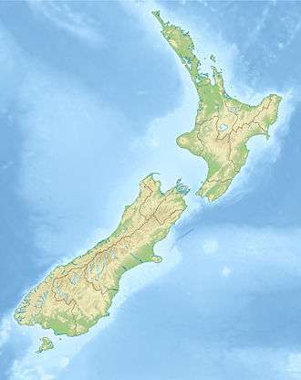
Mount Ruapehu (/ˈruːəˌpeɪhuː/; Māori: [ˈɾʉaˌpɛhʉ]) is an active stratovolcano at the southern end of the Taupo Volcanic Zone in New Zealand. It is 23 kilometres (14 mi) northeast of Ohakune and 23 km (14 mi) southwest of the southern shore of Lake Taupo, within Tongariro National Park. The North Island's major ski resorts and only glaciers are on its slopes.
| Mount Ruapehu | |
|---|---|
.JPG) Mt Ruapehu from Tongariro Northern Circuit, 2015 | |
| Highest point | |
| Elevation | 2,797 m (9,177 ft) [1] |
| Prominence | 2,797 m (9,177 ft) |
| Listing | Ultra New Zealand #19 |
| Coordinates | 39°17′S 175°34′E |
| Naming | |
| English translation | pit of noise or exploding pit[2] |
| Language of name | Māori |
| Geography | |
 Mount Ruapehu | |
| Geology | |
| Age of rock | ~200,000 years[1] |
| Mountain type | Stratovolcano |
| Volcanic arc/belt | Taupo Volcanic Zone |
| Last eruption | 25 September 2007 |
| Climbing | |
| First ascent | 1879 by G. Beetham and J. P. Maxwell |
| Easiest route | Hike |

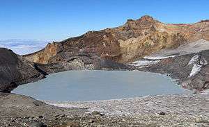
Ruapehu, the largest active volcano in New Zealand, is the highest point in the North Island and has three major peaks: Tahurangi (2,797 m), Te Heuheu (2,755 m) and Paretetaitonga (2,751 m). The deep, active crater is between the peaks and fills with water between major eruptions, being known as Crater Lake (Māori: Te Wai ā-moe).
Volcanic activity
Ruapehu is largely composed of andesite and began erupting at least 250,000 years ago. In recorded history, major eruptions have been about 50 years apart,[3] in 1895, 1945 and 1995–1996. Minor eruptions are frequent, with at least 60 since 1945. Some of the minor eruptions in the 1970s generated small ash falls and lahars (mudflows) that damaged skifields.[4]
Between major eruptions, warm acidic Crater Lake forms, fed by melting snow. Major eruptions may completely expel the lake water. Where a major eruption has deposited a tephra dam across the lake's outlet, the dam may collapse after the lake has refilled and risen above the level of its normal outlet, the outrush of water causing a large lahar. In 2000, the Eastern Ruapehu Lahar Alarm and Warning System (ERLAWS) system was installed on the mountain to detect such a collapse and alert the relevant authorities.
1945 eruption and aftermath
The 1945 eruption emptied Crater Lake and dammed the outlet with tephra. The crater slowly refilled with water, until on 24 December 1953 the tephra dam collapsed causing a lahar in the Whangaehu River. The lahar caused the Tangiwai disaster, with the loss of 151 lives, when the Tangiwai railway bridge across the Whangaehu River collapsed while the lahar was in full flood, just before an express train crossed it.
It was already known that the river had partially undermined one of the bridge piers and the lahar finished the job, causing the bridge to collapse. Although warned of the collapsed bridge, the train driver was unable to stop the train in time and six of the carriages fell into the river.
1995–1996 eruptions
Spectacular eruptions occurred during 1995 and 1996. Ruapehu had been showing signs of increased activity since late November 1994, with elevated Crater Lake temperatures and a series of eruptions that increased in intensity over about nine months. Several lahars were observed, both in the Whangaehu River and other areas of the mountain, between 18 September and 25 September 1995, indicating Crater Lake was being emptied by the eruptions.
The Department of Conservation immediately issued hazard warnings and advised people to keep off the mountain, thus ending the ski season. The eruption cloud disrupted air travel, occasionally closing airports and the central North Island airspace. Black sand-like ash fell on surrounding farmland and stock had to be moved. The ash also entered streams and was washed into the pen stocks and turbines of the Rangipo power station causing rapid corrosion on the turbine blades which had to be rebuilt. Episodic eruptions continued until the end of November 1995.
Within hours of a major eruption during the night being reported on 25 September 1995, news media were trying to get live video of the eruption and amateur photographers had published eruption images on the World Wide Web. A web camera, dubbed the world's first "Volcano Cam", was set up. Since then Ruapehu has been monitored by at least one and sometimes several volcano cams.
Another, smaller, eruption phase began on the morning of 17 June 1996. Despite a series of small eruptions that spread thin layers of ash across both Whakapapa and Turoa ski areas, the ski fields opened for the 1996 season. Turoa closed on 29 September – earlier than usual, while Whakapapa stayed open until Labour Weekend.
After the 1996 eruption it was recognised that a catastrophic lahar could again occur when Crater Lake bursts the volcanic ash dam blocking the lake outlet. This is the same mechanism that caused the 1953 lahar. The lake gradually filled with snowmelt and had reached the level of the hard rock rim by January 2005. The lahar finally occurred on 18 March 2007 (see below).
2006 eruption
Ruapehu erupted at 10.30pm on 4 October 2006. The small eruption created a volcanic earthquake at a magnitude of 2.8, sending a water plume 200 m into the air and 6 metres (20 ft) tall waves crashing into the wall of the crater.[5][6]
2007 lahar
On 18 March 2007, the tephra dam which had been holding back Crater Lake burst, sending a lahar down the mountain. An estimated 1.4 million cubic metres of mud, rock, and water travelled down the Whangaehu river. The Department of Conservation had received warning signals from ERLAWS at around 10:30 that morning and closed all major roads in the area, preventing thousands of motorists from travelling, and shut down the main rail system for the North Island. The river banks held and no spillovers occurred. There was no serious damage and no injuries. One family was trapped for around 24 hours after the lahar swept away the access route to their home.[7]
2007 eruption
At about 8:20 p.m. on 25 September 2007, a hydrothermal eruption occurred without warning.[8][9] One man, a 22-year-old primary school teacher, had a leg crushed by a rock during the eruption and a rescue operation was mounted to rescue him from the Dome Shelter near the crater. The rock crashed into the Dome Shelter, landed on the man and was too heavy for his companion to lift off.
Two lahars that travelled down the mountain activated warning signals from the lahar warning system and prompted the evacuation of some ski lodges on the mountain and the closure of roads in the area. The eruption was accompanied by a 7-minute-long earthquake, measuring 2.9 on the Richter Scale.
Warnings post-2007
On 2 May 2008, a level-1 warning was issued after GNS scientists who were monitoring the lake found irregular signs of volcanic activity. This included increased chemical changes, gases and temperature. The warning was used to let visitors know the potential of an explosion was higher than usual and could happen at any time. This could also be a follow-up to the previous year's 2007 eruption.[10]
A GeoNet New Zealand Bulletin was released on 21 July 2008 stating that "the current phase of volcano unrest appears to be over, however Ruapehu remains an active volcano. Future eruptions may occur without warning."[11] However the level has remained at 1, where it has been since 1997.
On 5 April 2011, Geonet changed Mount Ruapehu's Volcanic Aviation Colour Code from Green to Yellow (elevated unrest above the known background). Ruapehu's Volcanic Alert Level remained at level 1 (signs of volcanic unrest). The Volcanic Aviation Colour Code was changed because a sustained period of high water temperatures in the Crater Lake (approximately 38–39 °C) was observed and because changes were observed in volcanic gas output, seismic activity and Crater Lake water chemistry.[12]
On 16 November 2012, GNS Science volcanologists warned that pressure was likely building up beneath Crater Lake, and that an eruption in the coming weeks or months was more likely than normal.[13] The aviation colour code was raised from green to yellow.[14]
On 29 April 2016, Geonet issued a volcanic alert reporting that Crater Lake's temperature had risen to 40 °C (104 °F), up from 25 °C (77 °F) in mid-April. An earthquake swarm was also recorded under Crater Lake. On 11 May the volcanic alert level was raised to level 2 and the aviation colour code was changed from green to yellow.[15][16]
On 10 April 2019, Geonet issued a new alert, stating that the lake temperature had been cycling between 15 and 45 °C (59–113 °F) over the course of a year for the last decade,[17][18] but that this trend had been broken in September 2018, with the lake staying above 30 °C (86 °F) all summer.[17][18] For the 2 weeks leading up to 10 April, the lake had warmed further, at a rate of around 0.5 °C (0.90 °F) per day, reaching 42 °C (108 °F) on 9 April, a temperature exceeded by only 1% of temperature measurements in the preceding decade, most recently in May 2016.[17][18] While GeoNet retained the level 1 alert state, they added "it is a useful reminder that eruptions can occur with little or no warning".[18] On the 29th of April the crater lake temperature dropped to 39 °C (102 °F).[19]
On 26 Aug 2019 Crater Lake temperature rose to 27 °C (81 °F) from 14 °C (57 °F).[20]
Ski fields

Ruapehu has two commercial ski fields, Whakapapa on the northern side and Turoa on the southern slope. They are the two largest ski fields in New Zealand, with Whakapapa the larger. The club Tukino field is on the east of the mountain and is open to the public. The season is generally from June to October but depends on snow and weather conditions.
Both ski fields are accessible by car and chairlifts, with beginners' to advanced skiing slopes. Whakapapa has five chair lifts with limited accommodation and refreshments available at Top o' the Bruce (the car park at the top of Bruce Road) and at the entry to Whakapapa, and elsewhere on the mountain. Alpine huts are provided for trampers and climbers. These are mainly owned by private clubs.
Weather
Weather conditions can be changeable over the day, and mountain visitors are advised to be prepared and carry basic survival equipment. Although severe weather is unusual and generally forecast, it has claimed several lives over the years, including a party of five NZ Army soldiers and one RNZN naval rating, caught in a week-long storm while undergoing winter survival training in 1990.[21] The same storm also trapped an experienced Japanese mountaineer when the weather unexpectedly closed in on him, but he built a snow cave and sheltered in it until he was rescued days later.[22]

On 5 July 2003, about 350 skiers and 70 skifield staff were trapped on the mountain overnight at Top o' the Bruce when a sudden snow storm blew up and within a few minutes made the access road too dangerous to descend. They spent the night in relative comfort and all descended safely the next morning.[23] Such rapidly changing conditions are typical of the weather on New Zealand mountains.

Again on Saturday 26 July 2008, skiers and staff were trapped on the mountain overnight when a fast approaching storm caused the skifield to be closed at 10:30 a.m. and made the road too dangerous for cars without chains or 4WD to leave the area. By 3 p.m. there were still over 100 cars in the Whakapapa car park and those who had not been able to leave by that point were told to settle in for the night.[24] All cars were able to leave safely the next morning.
Climate
The climate found is maritime polar or tundra (Köppen: ET) for subpolar oceanic climate (Cfc).[25][26]
Glaciers
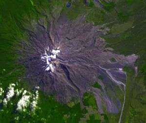
The glaciers on Mount Ruapehu are the only glaciers in the North Island. They are all less than 1.6 km (1 mi) in length. There are eighteen glaciers including one within the crater; the largest are the Mangatoetoenui, Summit Plateau and Whangaehu Glaciers.[27]
In popular culture
Some scenes of the fictional Mordor and Mount Doom in Peter Jackson's The Lord of the Rings film trilogy were filmed on the slopes of Mount Ruapehu.[28]
See also
References
- "Ruapehu". Global Volcanism Program. Smithsonian Institution. Retrieved 12 November 2016.
- "Volcano Fact Sheet: Ruapehu Volcano" (PDF). GNS Science. Retrieved 31 December 2013.
- New Zealand Department of Conservation. "Crater Lake". Retrieved 23 October 2006.
- New Zealand Department of Conservation. "Central North Island Volcanoes". Archived from the original on 29 December 2010. Retrieved 23 October 2006.
- "Ruapehu Volcanic warning update". Retrieved 27 November 2013.
- Feek, Belinda (7 October 2006). "High-risk warning on Ruapehu remains". Wanganui Chronicle.
- "Photos: Lahar could have been much worse". The New Zealand Herald. NZPA. 18 March 2007. Retrieved 26 October 2011.
- "GeoNet – alert bulletin: Sept 26 2007, 3:30 pm - Ruapehu Volcano". Geonet.org.nz. Retrieved 1 July 2013.
- "GeoNet – alert bulletin: Sept 27 2007, 12:30 pm - Ruapehu Volcano". Geonet.org.nz. Retrieved 1 July 2013.
- "Mt Ruapehu shows signs of erupting - DOC". The New Zealand Herald. 2 May 2008.
- "alert bulletin: Jul 21 2008, 3:00 pm - Ruapehu Volcano". Geonet.org.nz. 1 August 2008.
- "Volcanic Alert Bulletin RUA-2011/02". GeoNet. 5 April 2011.
- "Ruapehu eruption more likely". 3 News NZ. 16 November 2012.
- "Department of Conservation warns public to avoid Ruapehu". 3 News NZ. 17 November 2012.
- "GeoNet Ruapehu". geonet.org.nz. Retrieved 10 April 2018.
- "Mt Ruapehu alert level lifted after crater lake temperature rises 20C". 10 May 2016. Retrieved 10 April 2018 – via www.nzherald.co.nz.
- "Scientists monitoring Ruapehu as crater lake heats up". The New Zealand Herald. 10 April 2019. Retrieved 10 April 2019.
- Agnes Mazot (10 April 2019). "Te Wai ā-moe, Mt Ruapehu: Increases in lake temperature and seismic activity". Retrieved 10 April 2019.
- "Te Wai ā-moe, Mt Ruapehu crater lake is starting to cool and seismic activity decreases". Geonet. Retrieved 22 March 2020.
- "Mt Ruapehu crater lake (Te Wai ā-moe) is in a new heating cycle". Geonet. Retrieved 22 March 2020.
- "Special Honours List 1999". New Zealand Government. 23 October 1999. Retrieved 11 February 2009.
- "Japanese survives five days in blizzard". United Press International. 16 August 1990. Retrieved 14 May 2019.
- Charman, Paul (6 June 2014). "Outdoors: Preparing the snow". The New Zealand Herald. Retrieved 11 November 2016.
- "Northland cops it as storm sweeps island". Fairfax New Zealand. 26 July 2008. Archived from the original on 25 September 2008.
- "Interactive Australia / New Zealand Koppen-Geiger Climate Classification Map". www.plantmaps.com. Retrieved 6 March 2019.
- Peterson, Adam (21 July 2016), English: Köppen climate types in New Zealand, retrieved 6 March 2019
- "Glaciers in New Zealand". Te Ara: Encyclopaedia of New Zealand. Retrieved 24 November 2012.
- Sibley, Brian. The Making of the Movie Trilogy The Lord of the Rings, Houghton Mifflin (2002).
External links
| Wikimedia Commons has media related to: |
- "Ruapehu". Global Volcanism Program. Smithsonian Institution. Retrieved 18 December 2008.
- The 1996 Ruapehu Eruption Images and Information from Michigan Technological University
- Volcanic Hazards at Ruapehu Volcano - from GNS Science
- Volcano Camera - Mt Ruapehu - hourly photographs from GeoNet
- 2012 Warning from the Department of Conservation
- Ruapehu Eruption resources blog continuous since 1995 with new activity reported as it happens
- GeoNet New Zealand Alert Bulletins