Rio Branco, Acre
Rio Branco (Portuguese pronunciation: [ˈʁi.u ˈbɾɐ̃ku], White River) is a Brazilian municipality, capital of the state of Acre. Located in the valley of the Acre River in northern Brazil, it is the most populous municipality in the state, with 407,319 inhabitants, according to the 2018 census,[1] almost half the state population. Rio Branco was one of the first settlements to appear in the region, being the 4th oldest state capital city in the North of Brazil. In 1913, it became a county. In 1920, it became the capital of the territory of Acre, and in 1962, the state capital. It is the administrative center for the economic, political and cultural region.
Rio Branco | |
|---|---|
Municipality | |
| Município de Rio Branco Municipality of Rio Branco | |
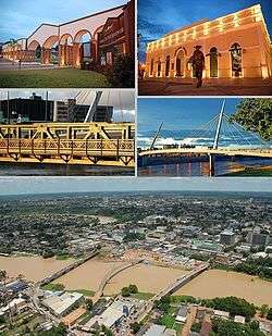 Rio Branco, Top left:Maternidade Park, Top right:Mercado Velho (Old Market) theme park, Middle left:JK Bridge, Middle right:A walkway in Passarela Joaquim Macedu theme park, Bottom:Panorama view of Acre River and downtown Benjamin Constant area | |
 Flag  Seal | |
| Nickname(s): "Capital da Natureza" (Capital of Nature), "Capital da Amazônia Ocidental" (Capital of Western Amazon) | |
| Motto(s): Ubique Patria Memor (Em Qualquer Lugar, Terei Sempre A Pátria Em Minha Lembrança) (Anywhere I will always have the homeland in my memory) | |
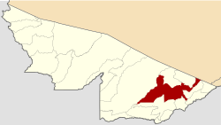 Location of Rio Branco in the State of Acre | |
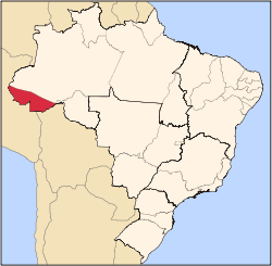
 Rio Branco Location in Brazil | |
| Coordinates: 9°58′29″S 67°48′36″W | |
| Country | |
| Region | North |
| State | |
| Founded | December 28, 1882 |
| Government | |
| • Mayor | Socorro Neri (PSB) |
| Area | |
| • Total | 8,835.68 km2 (3,411.48 sq mi) |
| Elevation | 143 m (469 ft) |
| Population (2018) | |
| • Total | 407,319 |
| • Density | 33.11/km2 (85.8/sq mi) |
| Time zone | UTC-4 (UTC-5) |
| Postal Code | 68900-000 |
| Area code(s) | +55 (68) |
| Website | www |
History
.tif.png)
The capital of the state of Acre emerged from the rubber plantation founded on December 28, 1882, by settlers from the Northeastern Region of Brazil. Then called Seringal Volta da Empresa, on the right bank of the Acre river, where the Gameleira tree is still today in place is also where the Second District of the city is located. Almost one and a half century ago, the construction of shacks had begun, in lands previously occupied by the Aquiris, Canamaris and Maneteris Amazonian indigenous tribes. Years later, the same Gameleira tree would be a witness to the battles fought at Volta da Empresa, between Acre revolutionaries and Bolivian troops, during the critical period of the Acre War, which made Acre part of Brazil, at the beginning of the 20th century. By August of 1904, Villa Rio Branco had established itself as the main urban center of the entire Acre valley, the richest and most productive in the region. During all these events, the streets around the Gameleira, on the right bank of the Acre River, were the center of commercial and urban life in this part of the Amazon. There were bars, cafes and casinos that moved the city's nightlife; there were the main commercial representatives of the national and foreign Aviation houses that handled thousands of Contos de Réis at that time of wealth and luxury. With the main affluent families of the urban elite, composed of liberal professionals and civil servants living in there, the then village thrived, creating Acre`s and the region`s first Bohemians. Although the political administration of the Territory was transferred to the left bank of the Acre River, the lands were higher and not floodable as the streets of the city centre. The remaining areas of the prior commercial zone, were gradually being dominated by Syrian and Lebanese immigrants, when in a point by mid-1930s, an area of it was known as "Bairro Beirut", (Beirut neighborhood). However, at the start of the 1950s, a clear process of economic decay began on the historic right bank of Acre river, in Rio Branco, which became to be known as the Second District. This resulted from the transfer of a large part of its main commercial houses to the city's First District, on the left bank of the river, where the main public offices and the residences of the most important families in the territory were already installed. Today, Rio Branco is looking at ways to reinvent itself, through International Relations with neighboring countries, the newly developed local Fish Farming industry and so on.
Geography
Rio Branco is located at 9° 58' 29" south and 67° 48' 36" west, at an altitude of 143 metres (469 ft) above sea level. The city is bisected by the Acre River, which divides it into the First and Second Districts. The river is crossed by six bridges, the newest bridge being the Joaquim Macedo Catwalk.
Rio Branco is located in the mesoregion of Vale do Jurua and the microregion of Rio Branco. It is bordered on the north by the municipalities of Bujari and Porto Acre; to the south by the municipalities of Xapuri, Capixaba, and Plácido de Castro; to the east by the municipality of Senador Guiomard; and to the west by the municipality of Sena Madureira.
Vegetation
The Amazon rainforest represents over half of the planet's remaining rainforests and comprises the largest and most species-rich tract of tropical rainforest in the world. Wet tropical forests are the most species-rich biome, and tropical forests in the Americas are consistently more species rich than the wet forests in Africa and Asia.[2] As the largest tract of tropical rain forest in the world, the Amazonian rainforests have unparalleled biodiversity. More than one-third of all species in the world live in the Amazon rainforest.[3]
The municipality contains part of the 931,537 hectares (2,301,880 acres) Chico Mendes Extractive Reserve, a sustainable use environmental unit created in 1990.[4]
Climate

The city of Rio Branco has the lowest average annual temperature among Legal Amazonian and Northeastern capitals. The city has a tropical monsoon climate, with temperatures between 23 and 33 °C or 73.4 and 91.4 °F during the hottest days of the year. The lowest temperatures occur at night, with frequent records of 22 °C or 71.6 °F at dawn. The period from December to March is the hottest time of year, with highs of 38 °C or 100.4 °F or more. Usually between May and August the Branco region experiences cooler weather, registering lower temperatures (around 15 °C or 59 °F) compared to regional standards. In July 2010 the city experienced record low temperatures. On the afternoon of the 17th, temperatures were registered to be 14.7 °C or 58.5 °F on average with a minimum of 12.1 °C or 53.8 °F. The 19th stood out with a minimum at 9.8 °C or 49.6 °F. However, the month's maximum reached 28 °C or 82.4 °F.[5]
Rio Branco has a lengthy wet season spanning from October through May and a relatively short dry season covering the remaining four months. The city on average sees roughly 1.9 metres or 6 feet 3 inches of rainfall annually. Rio Branco experiences its heaviest rainfall from December through March, averaging over 200 millimetres or 8 inches of precipitation per month during that timeframe.
| Climate data for Rio Branco (1981–2010, extremes 1892–present) | |||||||||||||
|---|---|---|---|---|---|---|---|---|---|---|---|---|---|
| Month | Jan | Feb | Mar | Apr | May | Jun | Jul | Aug | Sep | Oct | Nov | Dec | Year |
| Record high °C (°F) | 36.3 (97.3) |
37.2 (99.0) |
37.2 (99.0) |
38.2 (100.8) |
39.7 (103.5) |
35.2 (95.4) |
37.8 (100.0) |
38.3 (100.9) |
39.2 (102.6) |
38.4 (101.1) |
37.4 (99.3) |
39.8 (103.6) |
39.8 (103.6) |
| Average high °C (°F) | 30.9 (87.6) |
30.8 (87.4) |
31.1 (88.0) |
31.0 (87.8) |
30.4 (86.7) |
30.3 (86.5) |
31.3 (88.3) |
32.9 (91.2) |
33.2 (91.8) |
32.9 (91.2) |
31.8 (89.2) |
31.0 (87.8) |
31.5 (88.7) |
| Daily mean °C (°F) | 25.7 (78.3) |
25.5 (77.9) |
25.7 (78.3) |
25.4 (77.7) |
24.4 (75.9) |
23.6 (74.5) |
23.4 (74.1) |
24.6 (76.3) |
25.5 (77.9) |
26.1 (79.0) |
25.9 (78.6) |
25.7 (78.3) |
25.1 (77.2) |
| Average low °C (°F) | 22.2 (72.0) |
22.0 (71.6) |
22.0 (71.6) |
21.6 (70.9) |
20.1 (68.2) |
18.3 (64.9) |
17.5 (63.5) |
18.2 (64.8) |
19.8 (67.6) |
21.6 (70.9) |
21.9 (71.4) |
22.2 (72.0) |
20.6 (69.1) |
| Record low °C (°F) | 14.2 (57.6) |
16.0 (60.8) |
14.0 (57.2) |
10.4 (50.7) |
2.6 (36.7) |
7.8 (46.0) |
6.0 (42.8) |
8.0 (46.4) |
10.0 (50.0) |
12.4 (54.3) |
13.6 (56.5) |
13.4 (56.1) |
2.6 (36.7) |
| Average precipitation mm (inches) | 294.4 (11.59) |
298.4 (11.75) |
278.1 (10.95) |
207.4 (8.17) |
87.7 (3.45) |
32.8 (1.29) |
31.9 (1.26) |
56.5 (2.22) |
84.8 (3.34) |
153.0 (6.02) |
206.7 (8.14) |
265.9 (10.47) |
1,997.6 (78.65) |
| Average precipitation days (≥ 1.0 mm) | 19 | 17 | 17 | 13 | 8 | 3 | 3 | 4 | 6 | 10 | 14 | 18 | 132 |
| Average relative humidity (%) | 88.6 | 88.8 | 88.8 | 88.5 | 87.3 | 85.6 | 81.3 | 77.9 | 78.3 | 82.6 | 85.9 | 88.2 | 85.2 |
| Mean monthly sunshine hours | 109.7 | 90.4 | 113.8 | 127.4 | 154.8 | 174.3 | 218.4 | 180.5 | 158.0 | 162.8 | 138.8 | 118.6 | 1,747.5 |
| Source 1: Instituto Nacional de Meteorologia[6] | |||||||||||||
| Source 2: Meteo Climat (record highs and lows)[7] | |||||||||||||
Economy
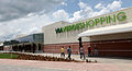 Via Verde Shopping Mall, the city`s largest.
 Rio Branco at night
Historically, the economy of Rio Branco has been based on Extractivism, especially Rubber and Brazil nuts. Currently, Wood is the main product of export in the state, which is also a major producer of Açaí fruit, Copaiba oil and Meat. Rio Branco is currently undergoing a transformation in its economy; transformation that includes an expansion to Agribusiness, Aquaculture and Ecotourism. Brazil`s largest oil and gas company Petrobras, says the region has potential for future Extraction of petroleum. [8][9][10]
Media
|
|
The city has six newspapers; two are published daily and four weekly. O Tabloide, A Gazeta, Página 20, A Tribuna, and O Estado are weekly newspapers. Cellular carriers who maintain coverage in the region are Vivo S.A., TIM, Oi, and Claro. The main companies offering fixed telephone coverage in the city are Embratel, Oi, and GVT.
Transportation
.jpg)
The public transport system has improved in recent years, mainly due to the construction of the Terminal Urbano (Urban Bus Terminal) near the center of town. However, the buses are still delayed. Taxis, including motorcycle taxis, are widely used by the population.
Rio Branco-Plácido de Castro International Airport is 18 kilometres (11 mi) away on the BR-364 highway in the rural area. This new airport was officially opened on November 22, 1999, when the older facility, Presidente Médici International Airport, was closed. The BR-364 was twinned to facilitate access to the airport, which serves domestic and international aviation and military operations, with scheduled airlines and air taxis. The terminal is ready to receive 320,000 passengers per year and performs about 14 operations a day. By August 2010 it was the seventh-busiest airport in Northern Brazil, and the 38th busiest airport in the country.
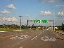
The BR-364 and the BR-317 are the main highways in Acre. To the east, the BR-364 connects Rio Branco to Southeastern Brazil. The highway cuts west across the state, linking Rio Branco to Cruzeiro do Sul, the second major city of the state, through the municipalities of Sena Madureira, Manoel Urbano, Feijó, Tarauacá, and Rodrigues Alves. The BR-317 has a length of 330 kilometres (210 mi), and links the capital to the south of the state, through the municipalities of Senador Guiomard, Capixaba, and Epitaciolândia, on the border with Republic of Bolivia. From Brasiléia the road continues for another 110 kilometres (68 mi) to reach the city of Assis Brasil on the border with Peru. The highway continues on the Peruvian side as part of the Interoceanic Highway[11] and as Highway 30C and Highway 26 to the city of Cuzco.
Attractions
The Rio Branco Palace was built in 1930 for the seat of the state government. The building was restored beginning in 1999 to preserve its historical character. In 2008 it was transformed into a museum of history.
Gameleira is a historical site located in the curve of the Acre River, where city was first founded. Today, more than a century later, the strangler fig located there is a vigorous tree, measuring 2.5 metres (8.2 ft) in diameter at the trunk and 20 metres (66 ft) in height.
Opened in 1958, the Cathedral of Our Lady of Nazareth was constructed in the style of an ancient Roman basilica. Its interior has three naves separated by 36 stained-glass windows, donated by families of Acre. The exterior is composed of gables, the cross, and the churchyard. In 2007 the church was considered public property of the state of Acre.
Also known as the Square of the Revolution, Square Plácido de Castro is located in the heart of the city, opposite the headquarters of the Military Police of Acre. Recently, the square underwent renovation. The Autonomists Memorial has a museum, exhibitions of paintings by regional artists, a coffee shop, and a drama theatre. The museum possesses a large collection of historic photos of the state, as well as historical objects used during the Revolution. The Museum of Rubber includes sections on archeology and paleontology, and a historical collection of manuscripts and documents relating to the history of Acre.
The Catwalk Joaquim Macedo is a pedestrian bridge linking the two districts of the city. Passing over the Acre River, the catwalk is a cable suspension bridge completed in 2006. The nearby Old Market, built in the 1920s, was recently refurbished. Maternity Park was opened on September 28, 2002. It has sports facilities, kiosks, restaurants, biking trails, and skate parks.
Rio Branco has two shopping malls: the Mira Shopping and the Via Verde Shopping, which was completed in 2011.[12]
The sepulcher of Raimundo Irineu Serra, founder of the religion known internationally as Santo Daime, is located in the Alto Santo neighborhood and has become a place of international pilgrimage.
Demographics
.jpg)
The population of the municipality in 2009 was estimated at 305,954 inhabitants by the Brazilian Institute of Geography and Statistics (IBGE). It is the largest city in the state and one of Brazil's most populous. The population density of 33.17 inhabitants per square kilometer. According to the 2000 census, 51% of the population are male and 48.2% female; 92.73% of the population lives in urban areas and 7.22% live in rural areas. According to the Atlas of Human Development in Brazil, the population of Rio Branco is 0.16% of the national population. According to the Superior Electoral Court, Rio Branco had 201,966 voters in 2008 .
The Municipal Human Development Index of Rio Branco is considered average by the United Nations Development Programme, with a value of 0.754. The education index is 0.860, while Brazil's is 0.849. The rate of longevity is 0.697 (the Brazilian rate is 0.638) and income is 0.704 (Brazil's is 0.723). The Gini coefficient, which measures inequality, is 0.52, where 1.00 is the worst result and 0.00 is the best. The incidence of poverty, as measured by the IBGE, is 37.21 per cent, and the incidence of subjective poverty is 39.39 per cent.
Education
In 2009 the city of Rio Branco had 211 elementary schools, with 64,349 students and 2,367 teachers. The Index of Basic Education Development for elementary schools was 4.9, ranked 10th among Brazilian capitals, and above the national average of 4.6. There are an estimated 70 kindergarten preschools with 402 teachers and 10,168 students.
Higher education institutions include the Federal University of Acre (UFAC), the Northern Educational Union, the College of the Western Amazonia, and the Community College of Acre, among others. These absorb the bulk of registrations, especially the Federal University of Acre, as the only public college in the state.
In 2008, the illiteracy rate in the state was 13 per cent, with 36.2 per cent of the population functionally illiterate.
Sports
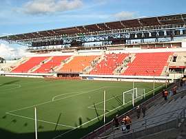
Rio Branco provides visitors and residents with various sport activities. The three main football teams in Acre are based in Rio Branco: Rio Branco FC, Juventus and Atlético Acreano. Stadiums in the city are the Arena da Floresta stadium; José de Melo stadium; Federação Acreana de Futebol stadium; Dom Giocondo Maria Grotti stadium; and Adauto de Brito stadium. Rio Branco was one of 18 candidates shortlisted to host games of the 2014 FIFA World Cup, for which Brazil was the only South American bidder. The city's bid was rejected.
Sister cities
Notable People
- Weverton Pereira da Silva Football player
- Alan Rick Politician
- Marina Silva Environmentalist
Image gallery
 Aerial view of old town Rio Branco, Brazil
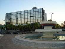 Rio Branco in the afternoon
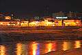 View of the city centre
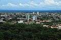 View of Rio Branco, Acre
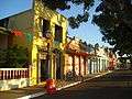 Historic houses of Rio Branco, Brazil
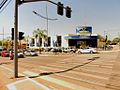 Rio Branco, Brazil
.jpg) Canal da Maternidade, Rio Branco of Acre
Canal da Maternidade, Rio Branco of Acre Via Verde ring road, Rio Branco, Brazil
 Casa dos Povos da Floresta Museum, Rio Branco, Brazil
 Downtown Rio Branco, the city`s Old Market (Mercado Velho), Brazil
.jpg) Event at Palácio Rio Branco, Rio Branco, Brazil
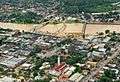
Event at Palácio Rio Branco, Rio Branco, Brazil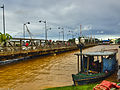 Flood of Acre River, Rio Branco, Brazil
References
- https://cidades.ibge.gov.br/brasil/ac/rio-branco/panorama
- Turner, I.M. 2001. The Ecology of Trees in the Tropical Rainforest. Cambridge University Press, Cambridge. ISBN 0-521-80183-4
- Amazon Rainforest, Amazon Plants, Amazon River Animals
- Unidade de Conservação: Reserva Extrativista Chico Mendes (in Portuguese), MMA: Ministério do Meio Ambiente, retrieved 2016-06-04
- http://worldweather.wmo.int/136/c01079.htm
- "Normais Climatológicas Do Brasil 1981–2010" (in Portuguese). Instituto Nacional de Meteorologia. Retrieved 20 October 2018.
- "Station Rio Branco" (in French). Meteo Climat. Retrieved 20 October 2018.
- https://petrobras.com.br/fatos-e-dados/blocos-na-bacia-do-acre-e-exploracao-de-gas-de-xisto-respostas-a-folha-de-s-paulo.htm
- https://sistemas.mre.gov.br/kitweb/datafiles/Miami/en-us/file/Opportunities_in_the_Brazilian_Oil_and_Gas_Industry.pdf
- https://www.ceicdata.com/en/brazil/petroleum-sales-by-state-acre/petroleum-product-sales-acre-barrel-diesel
- Reel, Monte (19 February 2014). "Traveling From Ocean to Ocean Across South America". New York Times.
- http://viaverdeshopping.com.br/
External links
- http://www.riobranco.ac.gov.br Rio Branco's municipal government
- http://turbrasil.com/rio_branco_hotels.hrg.3.en Hotels in Rio Branco
| Authority control |
|
|---|