Teresina
Teresina is the capital and most populous municipality in the Brazilian state of Piauí. Being located in north-central Piauí 366 km from the coast, it is the only capital in the Brazilian Northeast that is not located on the shores of the Atlantic Ocean. With 861,442 inhabitants, Teresina is the 21st largest city in Brazil, and the 15th largest state capital in the country. Together with Timon in the nearby state of Maranhão, it forms a conurbation with a population of about 953,172 inhabitants; the entire metropolitan region of Teresina has over 1,135,920 inhabitants. The only natural barrier that separates Teresina from Timon is the Parnaíba river, one of the largest in the Northeast.
Teresina, Piauí, Brazil | |
|---|---|
Municipality | |
| The Municipality of Teresina | |
 | |
 Flag  Seal | |
| Nickname(s): Capital do Sol e da Luz (Capital of Sun and Light), Cidade Verde (Green City) and THE. | |
| Motto(s): Omnia in Charitate | |
 Location of Teresina in the State of Piauí | |
 | |
 Teresina, Piauí, Brazil Location in Brazil | |
| Coordinates: 5°05′42″S 42°48′15″W | |
| Country | |
| Region | Northeast |
| State | |
| Founded | August 16, 1852 |
| Government | |
| • Mayor | Firmino Filho (PSDB) |
| Area | |
| • Municipality | 1,167.25 km2 (450.68 sq mi) |
| • Urban | 1,755 km2 (677 sq mi) |
| Elevation | 87 m (285 ft) |
| Population (2018 est.[1]) | |
| • Municipality | 861,442 |
| • Density | 740/km2 (1,900/sq mi) |
| • Urban | 953,172 |
| • Metro | 1,135,920 |
| Time zone | -3 |
| Postal Code | 64000-000 |
| Area code(s) | (+55) 86 |
| Demonym | teresinense |
| Website | Teresina, Piauí |
Teresina is the capital with the second best quality of life in the North-Northeast according to FIRJAN. According to IPEA, Teresina is the third safest capital of Brazil (only after Natal and Palmas). It is also among the 50 cities in the world with the highest murder rates, with 315 homicides in 2017.[2]
Its motto is the Latin phrase Omnia in Charitatis, which means, in English, "All for charity". The city is the birthplace of, among others, Torquato Neto, who belonged to the Tropicalismo movement.
Its Cathedral Catedral Metropolitana Nossa Senhora das Dores, dedicated to Our Lady of Sorrows, is the archiepiscopal see of the Roman Catholic Archdiocese of Teresina.
History and names
Teresina was founded on August 16, 1852 under the name of Vila Nova do Poty (because its origin is linked to the Poti river) as the capital of the state of Piauí. It was the first planned city in the Brazil and the only northeast capital located out of the coast. Until 1852, Oeiras was the capital of the Piauí Captaincy. However, due to difficulties in communication and trade, the capital was transferred to an area next to the Parnaíba River, to the other cities and to the sea coast. Colonization of the area where Teresina is now located dates back to the 18th century. The chosen place was a small community of fishermen, in 1760, nearby Poty and Panaíba rivers, which grew into a village called "Vila do Poty", but, due to the inundation of the Parnaíba River riverbanks, the city had to be built in a higher position.
In the 19th century, it was initially called Vila Nova do Poty, but later the city was renamed Teresina, in honor of the Empress Teresa Cristina, the wife of the Emperor of Brazil, Pedro II.
Teresina is the hottest city in the country and the third city with the major incidence of lightning in the world. Nowadays, Teresina's economy is based on international manufacturing industries and trade.
Main sights
Sights include:
- Casa da Cultura de Teresina, exhibiting elements of the culture of the city, and home to cultural events
- Centro Artesanal "Master Dezinho", home to handcrafts made of various materials, mainly clay, decorated with paintings;
- Teatro 4 de Setembro, a theatre holding cultural shows, plays and others;
- Mirante da Ponte Estaiada "João Isidoro França"
- Encontro dos Rios, a natural place by the riverside Parnaíba and Poti.
- Parque Zoobotânico, a zoo with typical animals of the Brazilian fauna and other countries.
- Igreja de São Benedito, the main Catholic church of the city
- Museu do Piaui, with numerous elements of the history of Teresina and of Piauí in general, including antiques, furniture and documents.
Geography
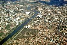
Teresina is located on the east side of the Parnaíba river at the border with Maranhão state, at an altitude of about 72 meters. The city faces the city of Timon across the river and is situated between the Parnaíba river and its tributary the Poti River. The two rivers join at the city's northern end, where there is an environmental park with gazebos. Teresina is the largest capital in the northeastern territorial extension, with 1.755,698 km².
Located in a transition zone between the northeast and the Amazon (Mid-North), Teresina is surrounded by mata dos cocais, savannas and cerradões where many carnaúba, babaçu, buriti palms, jatobás, ipês, and many other medium-sized trees can be seen. In the region there are also remnants of Teresina Atlantic Forest, which makes the landscape shrub coverage very rich and dense.
Climate
Teresina has a tropical wet and dry climate (Köppen climate classification: Aw) with two seasons with semi-humid characteristics: the rainy season (which occurs in summer and autumn) and the dry season (which occurs in winter and spring).
From January to May, due to the rains, the weather is warm and wet (likely to occur when there is fog in the morning), while from June to August the climate gets dry with relatively cool nights; in September to December the weather becomes hotter and humid, with the gradual return of rainy conditions from October. This Period during the year is referred to as "Bro" by locals as the hottest months end with -bro in Portuguese: setembro, outubro, novembro, and dezembro. A peculiar feature of the rains in the city are their speed and intensity, with strong winds, large force of water and very common lightning. The annual rainfall stands at around 1,400 mm.
Hot most of the year, Teresina has an average temperature around 27 °C, with a minimum of 20 °C in July and a maximum of 36 °C in October. The lowest ever recorded in Teresina was 12 °C in June, while in the hottest season, the record exceeds 40 °C (October). These fluctuations are mitigated by the contribution of the winds. Air quality is considered good in Teresina, except in the driest period, when the relative humidity drops, and there are occurrences of fires.
| Climate data for Teresina (1961–1990) | |||||||||||||
|---|---|---|---|---|---|---|---|---|---|---|---|---|---|
| Month | Jan | Feb | Mar | Apr | May | Jun | Jul | Aug | Sep | Oct | Nov | Dec | Year |
| Record high °C (°F) | 38.4 (101.1) |
36.6 (97.9) |
39.6 (103.3) |
35.0 (95.0) |
35.0 (95.0) |
35.9 (96.6) |
37.2 (99.0) |
38.0 (100.4) |
39.6 (103.3) |
40.3 (104.5) |
39.7 (103.5) |
39.5 (103.1) |
40.3 (104.5) |
| Average high °C (°F) | 32.2 (90.0) |
31.5 (88.7) |
31.8 (89.2) |
31.6 (88.9) |
31.8 (89.2) |
32.4 (90.3) |
33.3 (91.9) |
35 (95) |
35.8 (96.4) |
36.4 (97.5) |
35.4 (95.7) |
34.2 (93.6) |
33.5 (92.3) |
| Daily mean °C (°F) | 26.7 (80.1) |
26.1 (79.0) |
26.1 (79.0) |
26.2 (79.2) |
26.4 (79.5) |
26.1 (79.0) |
26.2 (79.2) |
26.8 (80.2) |
28.8 (83.8) |
29.3 (84.7) |
28.8 (83.8) |
28.1 (82.6) |
27.1 (80.8) |
| Average low °C (°F) | 22.5 (72.5) |
22.4 (72.3) |
22.4 (72.3) |
22.7 (72.9) |
22.4 (72.3) |
21.2 (70.2) |
20.4 (68.7) |
20.5 (68.9) |
22 (72) |
22.8 (73.0) |
23 (73) |
23.1 (73.6) |
22.1 (71.8) |
| Record low °C (°F) | 20.2 (68.4) |
20.2 (68.4) |
20.3 (68.5) |
19.9 (67.8) |
19.4 (66.9) |
11.9 (53.4) |
15.0 (59.0) |
15.6 (60.1) |
18.2 (64.8) |
19.0 (66.2) |
19.8 (67.6) |
20.4 (68.7) |
11.9 (53.4) |
| Average rainfall mm (inches) | 177.7 (7.00) |
268 (10.6) |
297.8 (11.72) |
272.4 (10.72) |
113.2 (4.46) |
24.1 (0.95) |
10.5 (0.41) |
8.4 (0.33) |
9.1 (0.36) |
20.4 (0.80) |
73.2 (2.88) |
118.4 (4.66) |
1,393.2 (54.85) |
| Average rainy days (≥ 1 mm) | 11 | 15 | 19 | 16 | 10 | 3 | 1 | 1 | 2 | 2 | 4 | 7 | 91 |
| Average relative humidity (%) | 75 | 83 | 83 | 84.1 | 81 | 72 | 65 | 59 | 56 | 58 | 60 | 64 | 70 |
| Mean monthly sunshine hours | 185.9 | 151 | 167.8 | 175.9 | 243.2 | 264.1 | 296.7 | 314.6 | 282 | 266.6 | 232.6 | 201.3 | 2,781.7 |
| Source: Brazilian National Institute of Meteorology (INMET).[3][4][5][6][7][8][9][10][11] | |||||||||||||
Health
In Teresina there are 634 health institutions, eight hospitals, 181 clinics and 170 clinics, employing some 15,000 people.
Moreover, there is a significant number of small "pensions" that host people from the hinterland of Piauí and neighboring states in search of health services in Teresina.
Education
Portuguese is the official national language, and thus the primary language taught in schools. But English and Spanish are part of the official high school curriculum.
Universities in Teresina
- Universidade Federal do Piauí (UFPI);
- Universidade Estadual do Piauí (Uespi);
- Instituto Federal de Educação, Ciência e Tecnologia do Piauí (IFPI).
- Faculdade de Saúde, Ciências Humanas e Tecnológicas do Piauí (Faculdade Novafapi)
- Faculdade Integral Diferencial (Facid)
- Instituto Camilo Filho (ICF)
- Centro de Ensino Unificado de Teresina (CEUT)
- Faculdade das Atividades Empresariais de Teresina[12] (FAETE)
Economy
The Gross Domestic Product of Teresina represents about 40% of GDP in the state of Piaui. In industry, there is the textile and garment industry, which exports to other regions and generates about ten thousand jobs. There are also manufacturers bicycles, drink industries, pharmaceuticals, chemicals, furniture and ceramics, among others. The building deserves to be a fast-growing sector due to the verticality of the city over the past 15 years.
Transportation
Teresina has a subway service comprising nine different stations. There is also bus service through the city. Teresina/Senador Petrônio Portella Airport, opened in 1967, lies north of the capital, between the rivers Parnaíba and Poty.
 Residential highrises seen from Teresina Shopping.
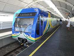 Teresina Metro.
Sports
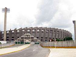
The Albertão Stadium holds 60,000 spectators, houses soccer, athletics and other games. A smaller stadium (6,000 places) is the Lindolfo Monteiro Stadium, opened in 1944. It was restored in 2008.
Football teams Teresina include Flamengo-PI, River-PI, Tiradentes and Piauí-PI. Rugby teams include Teresina Rugby Club, Lions Rugby Club, Rugby Titans Clash.
References
- "Brazilian Institute of Geography and Statistics" (in Portuguese). 2017. Archived from the original on 27 March 2019. Retrieved 27 March 2019.
2018 Area Total
- "State of Piauí (Center on Crime and Statistical Analysis) Annual Report on Crime" (PDF). January 2018. Archived (PDF) from the original on 2018-03-13.
- "Temperatura Média Compensada (°C)" (in Portuguese). Brazilian National Institute of Meteorology. 1961–1990. Archived from the original on August 8, 2014. Retrieved September 8, 2014.
- "Temperatura Máxima (°C)" (in Portuguese). Brazilian National Institute of Meteorology. 1961–1990. Archived from the original on August 8, 2014. Retrieved September 8, 2014.
- "Temperatura Mínima (°C)" (in Portuguese). Brazilian National Institute of Meteorology. 1961–1990. Archived from the original on August 8, 2014. Retrieved September 8, 2014.
- "Precipitação Acumulada Mensal e Anual (mm)" (in Portuguese). Brazilian National Institute of Meteorology. 1961–1990. Archived from the original on August 8, 2014. Retrieved September 8, 2014.
- "Número de Dias com Precipitação Maior ou Igual a 1 mm (dias)". Brazilian National Institute of Meteorology. Archived from the original on August 27, 2014. Retrieved September 8, 2014.
- "Insolação Total (horas)". Brazilian National Institute of Meteorology. Archived from the original on August 8, 2014. Retrieved September 8, 2014.
- "Umidade Relativa do Ar Média Compensada (%)". Brazilian National Institute of Meteorology. Archived from the original on August 8, 2014. Retrieved September 8, 2014.
- "Temperatura Máxima Absoluta (ºC)". Brazilian National Institute of Meteorology (Inmet). Retrieved September 8, 2014.
- "Temperatura Mínima Absoluta (ºC)". Brazilian National Institute of Meteorology (Inmet). Retrieved September 8, 2014.
- "Archived copy". Archived from the original on 2019-05-02. Retrieved 2019-10-05.CS1 maint: archived copy as title (link)
External links
| Wikimedia Commons has media related to Teresina. |
| Wikivoyage has a travel guide for Teresina. |
- Official website (in Portuguese)
- Teresina Info—Bilingual tourist information (in English)
- Panoramic Teresina—Tourist information (in Portuguese and English)
- Visit Piauí—Tourist information (in English)
| Authority control |
|
|---|