Cruzeiro do Sul, Acre
Cruzeiro do Sul (Portuguese pronunciation: [kɾuˈzejɾu du ˈsuw], Southern Cross) is a municipality located on the Juruá river in the west of the Brazilian state of Acre. It is the second-largest city in Acre.
Cruzeiro do Sul, Acre | |
|---|---|
 City centre, Cruzeiro do Sul Cathedral can be seen with its Germanic architecture alongside Juruá River, Acre, Brazil. | |
.svg.png) Flag  Seal | |
| Nickname(s): Land of the Nahuas (Portuguese: Terra dos Nauas) | |
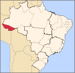
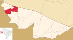 Location in Acre | |
 Cruzeiro do Sul, Acre Location in Brazil | |
| Coordinates: 7°37′51″S 72°40′12″W | |
| Country | |
| Region | North |
| State | |
| Founded | September 12, 1904 |
| Government | |
| • Mayor | Ilderlei Cordeiro (PMDB) |
| Area | |
| • Total | 7,924.943 km2 (3,059.838 sq mi) |
| Elevation | 182 m (597 ft) |
| Population (2012) | |
| • Total | 79,819 |
| • Density | 10.07/km2 (26.1/sq mi) |
| Demonym(s) | cruzeirense[1] |
| Time zone | UTC-5 (ACT) |
| CEP postal code | 69980-000 |
| Area code | +55 68 |
| Website | cruzeirodosul.ac.gov.br |
It is bordered to the north by the state of Amazonas, to the south by Peru, to the east by the municipality of Porto Walter, to the west by the municipality of Rodrigues Alves, to the northwest by the municipality of Tarauacá, and to the northwest by the municipality of Mâncio Lima.
The municipality contains 23% of the 846,633 hectares (2,092,080 acres) Serra do Divisor National Park, created in 1989.[2]
Economy
The principal economic activity of the municipality is rubber extraction. Of lesser importance is the farming of cassava, coffee and rice.
Transport
The town is served by Cruzeiro do Sul International Airport.
Climate

Though the town has a tropical climate typical of the Amazon region, it is notable for sporadic cold spells not typically found in low-lying equatorial areas. The temperature has twice reached 2°C.
| Climate data for Cruzeiro do Sul, Acre (1981–2010, extremes 1941–present) | |||||||||||||
|---|---|---|---|---|---|---|---|---|---|---|---|---|---|
| Month | Jan | Feb | Mar | Apr | May | Jun | Jul | Aug | Sep | Oct | Nov | Dec | Year |
| Record high °C (°F) | 36.6 (97.9) |
36.8 (98.2) |
39.0 (102.2) |
38.5 (101.3) |
39.9 (103.8) |
38.0 (100.4) |
37.2 (99.0) |
38.1 (100.6) |
39.5 (103.1) |
38.7 (101.7) |
37.8 (100.0) |
38.8 (101.8) |
39.9 (103.8) |
| Average high °C (°F) | 31.5 (88.7) |
31.5 (88.7) |
31.6 (88.9) |
31.5 (88.7) |
31.0 (87.8) |
30.9 (87.6) |
31.5 (88.7) |
32.5 (90.5) |
32.8 (91.0) |
32.7 (90.9) |
32.0 (89.6) |
31.6 (88.9) |
31.8 (89.2) |
| Daily mean °C (°F) | 25.9 (78.6) |
25.7 (78.3) |
25.7 (78.3) |
25.7 (78.3) |
25.1 (77.2) |
24.8 (76.6) |
24.8 (76.6) |
25.5 (77.9) |
25.8 (78.4) |
26.0 (78.8) |
25.8 (78.4) |
25.8 (78.4) |
25.6 (78.1) |
| Average low °C (°F) | 21.3 (70.3) |
21.2 (70.2) |
21.3 (70.3) |
21.1 (70.0) |
20.3 (68.5) |
19.3 (66.7) |
18.6 (65.5) |
19.2 (66.6) |
20.0 (68.0) |
20.9 (69.6) |
21.0 (69.8) |
21.2 (70.2) |
20.5 (68.9) |
| Record low °C (°F) | 10.7 (51.3) |
10.1 (50.2) |
9.8 (49.6) |
11.3 (52.3) |
2.3 (36.1) |
6.2 (43.2) |
7.1 (44.8) |
6.9 (44.4) |
6.8 (44.2) |
8.1 (46.6) |
2.2 (36.0) |
10.3 (50.5) |
2.2 (36.0) |
| Average precipitation mm (inches) | 247.0 (9.72) |
258.3 (10.17) |
292.6 (11.52) |
232.8 (9.17) |
155.6 (6.13) |
89.7 (3.53) |
59.1 (2.33) |
76.4 (3.01) |
113.2 (4.46) |
191.0 (7.52) |
222.2 (8.75) |
229.5 (9.04) |
2,167.4 (85.33) |
| Average precipitation days (≥ 1.0 mm) | 17 | 17 | 18 | 15 | 12 | 7 | 6 | 6 | 8 | 13 | 15 | 17 | 151 |
| Average relative humidity (%) | 84.0 | 84.2 | 85.1 | 84.5 | 83.2 | 82.6 | 78.6 | 77.9 | 77.8 | 81.7 | 83.7 | 83.9 | 82.3 |
| Mean monthly sunshine hours | 82.4 | 62.1 | 74.0 | 88.6 | 120.1 | 117.5 | 182.3 | 162.3 | 133.1 | 127.9 | 103.0 | 84.2 | 1,337.5 |
| Source 1: Instituto Nacional de Meteorologia[3] | |||||||||||||
| Source 2: Meteo Climat (record highs and lows)[4] | |||||||||||||
Gallery
%2C_Fundo_Correio_da_Manh%C3%A3_-_2.tif.jpg) Cruzeiro do Sul in 1906
Cruzeiro do Sul in 1906 Catedral de Nossa Senhora da Glória, Brazil
 Union Bridge (Portuguese: Ponte da União) in Cruzeiro do Sul runs to the state capital Rio Branco, through the BR-364, Brazil
.jpg)
 Juruá Hospital
References
- "IBGE - Cidades". O Brasil Município por Município. Brazilian Institute of Geography and Statistics (IBGE). Retrieved 2018-08-23.
- PARNA da Serra do Divisor (in Portuguese), ISA: Instituto Socioambiental, retrieved 2016-08-08
- "Normais Climatológicas Do Brasil 1981–2010" (in Portuguese). Instituto Nacional de Meteorologia. Retrieved 20 October 2018.
- "Station Cruzeiro do Sul" (in French). Meteo Climat. Retrieved 20 October 2018.
External links
| Wikimedia Commons has media related to Cruzeiro do Sul (Acre). |
- (in Portuguese) Bem-vindo à Cruzeiro do Sul