Porto Velho
Porto Velho (Portuguese pronunciation: [ˈpoʁtu ˈvɛʎu], Old Port) is the capital of the Brazilian state of Rondônia, in the upper Amazon River basin, and a Catholic Metropolitan Archbishopric. The population is 519,531 people (as of the IBGE 2018 estimation).[1] Located on the border of Rondônia and the state of Amazonas, the town is an important trading center for cassiterite, the mining of which represents the most important economic activity in the region, as well as a transportation and communication center. It is on the eastern shore of the Madeira River, one of the main tributaries of the Amazon River. It is also Rondônia's largest city, and the largest state capital of Brazil by area.
Porto Velho | |
|---|---|
Municipality | |
| The Municipality of Porto Velho | |
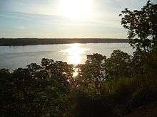
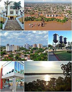 Top left:Rondonia State Government Office, Top right:Port of Porto Velho, Middle left:Porto Velho Cultural House, Middle right:Sunset in Madeira River, Bottom:Panorama view of downtown from Pedrinhas area | |
 Flag  Seal | |
 Location of Porto Velho in the State of Rondônia | |
 Porto Velho Localization of Porto Velho in Brazil | |
| Coordinates: 8°45′43″S 63°54′14″W | |
| Country | |
| Region | North |
| State | |
| Founded | October 2, 1914 |
| Government | |
| • Mayor | Hildon Chaves (PSDB) |
| Area | |
| • Total | 34,082.37 km2 (13,159.28 sq mi) |
| Elevation | 83 m (272 ft) |
| Population (2018 est.[1]) | |
| • Total | 519,531 |
| • Density | 15/km2 (39/sq mi) |
| Time zone | UTC-4 (UTC-4) |
| Postal Code | 76800-000 |
| Area code(s) | (+55) 69 |
| Website | Porto Velho, Rondônia |
The municipality occupies most of the border between Amazonas and Rondônia, and is both the westernmost and northernmost city in the state.
History
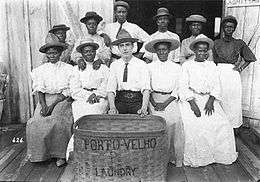
Officially founded on October 2, 1914, Porto Velho was founded by pioneers around 1907, during the construction of the Madeira-Mamoré railroad. After the railroad was completed, the local population was about one thousand inhabitants; its buildings Arthur Oliveira were chiefly the railway's installations and the wooden houses of the Caribbean (mainly Barbadian) workers - hence the name of the town's largest district by then, "Bajan Hill" or "Barbados Town", nowadays called the "Alto do Bode".
During the first sixty years, the city's development was directly connected to the railway's activities. The town prospered during the rubber boom, but then when low-cost Malaysian rubber made rubber from the Amazon uncompetitive, the region's economy ground to a halt. Cities like Santo Antônio do Madeira, which had a tram line and a weekly newspaper by the time of Porto Velho's foundation, are nothing but ruins nowadays.
Porto Velho's survival is associated with the better conditions of the area where it was built, its easy access by the river and its harbor: these were all considerations in the choice of Porto Velho as the capital of the newly formed Federal Territory of Guaporé, in 1943. Only with the beginning of World War II was there another cycle of progress in the region. When the Allied forces lost control over the Malaysian rubber, Amazon's was needed due to the war effort. This produced what is known in Brazil as the "second rubber boom". But when the war ended, the region's economy once again came to a halt.
Porto Velho's modern history begins with the discovery of cassiterite around the city, and of gold on the Madeira River, at the end of the 1950s. In addition, the government's decision to allow large cattle farms in the territory began a trend of migration into the city. Almost one million people moved to Rondônia, and Porto Velho's population increased to three hundred thousand. This intense migration caused much trouble for the city. Among many other problems, the suburban boroughs, for example, are nothing but shanty towns.
Its Catedral Metropolitana Sagrado Coração de Jesus, is the cathedral archiepiscopal see of a Latin Catholic jurisdiction that started on 1925.05.01 as the vast Amazonian Territorial Prelature of Porto Velho on territories split off from the then Diocese of Amazonas and Diocese of São Luíz de Cáceres and lost parts of it to three new Territorial prelatures before being promoted first bishopric (Diocese of Porto Velho) and on 1982.10.04 promoted as Metropolitan Archdiocese of Porto Velho.
Geography
Climate
Porto Velho features a tropical monsoon climate (climate type Am) under the Köppen climate classification. The temperatures tend to be relatively consistent throughout the course of the year, with average daily temperatures typically between 25 and 26 degrees Celsius.[2] The dry season is short and covers the months of June, July and August. Porto Velho is particularly wet from November through April, averaging roughly 200 mm (7.9 in) of rain per month in each of these months.[3] According to the Brazilian National Institute of Meteorology (INMET), between 1961 and 1990 the lowest temperature recorded in Porto Velho was 7.4 °C or 45.3 °F in July 1975,[4] and the highest reached 40.9 °C or 105.6 °F in August 1969.[5]
| Climate data for Porto Velho (1961–1990) | |||||||||||||
|---|---|---|---|---|---|---|---|---|---|---|---|---|---|
| Month | Jan | Feb | Mar | Apr | May | Jun | Jul | Aug | Sep | Oct | Nov | Dec | Year |
| Record high °C (°F) | 37.2 (99.0) |
36.4 (97.5) |
38.7 (101.7) |
37.1 (98.8) |
36.8 (98.2) |
38.8 (101.8) |
37.9 (100.2) |
40.9 (105.6) |
39.4 (102.9) |
40.0 (104.0) |
39.7 (103.5) |
38.0 (100.4) |
40.9 (105.6) |
| Average high °C (°F) | 31.3 (88.3) |
31.5 (88.7) |
31.7 (89.1) |
31.6 (88.9) |
31.6 (88.9) |
31.7 (89.1) |
32.7 (90.9) |
34.3 (93.7) |
34.0 (93.2) |
33.3 (91.9) |
32.6 (90.7) |
31.6 (88.9) |
32.3 (90.1) |
| Daily mean °C (°F) | 25.5 (77.9) |
25.5 (77.9) |
25.6 (78.1) |
25.7 (78.3) |
25.3 (77.5) |
24.7 (76.5) |
24.6 (76.3) |
25.9 (78.6) |
26.2 (79.2) |
26.1 (79.0) |
26.0 (78.8) |
25.5 (77.9) |
25.6 (78.1) |
| Average low °C (°F) | 21.7 (71.1) |
21.8 (71.2) |
21.8 (71.2) |
21.9 (71.4) |
21.0 (69.8) |
19.2 (66.6) |
18.3 (64.9) |
19.0 (66.2) |
20.8 (69.4) |
21.8 (71.2) |
22.0 (71.6) |
22.0 (71.6) |
20.9 (69.6) |
| Record low °C (°F) | 14.4 (57.9) |
15.4 (59.7) |
12.0 (53.6) |
12.8 (55.0) |
12.0 (53.6) |
11.8 (53.2) |
7.4 (45.3) |
10.0 (50.0) |
12.1 (53.8) |
17.7 (63.9) |
18.1 (64.6) |
11.0 (51.8) |
7.4 (45.3) |
| Average rainfall mm (inches) | 320.9 (12.63) |
316.0 (12.44) |
273.9 (10.78) |
251.0 (9.88) |
126.6 (4.98) |
49.2 (1.94) |
24.2 (0.95) |
36.4 (1.43) |
119.9 (4.72) |
192.7 (7.59) |
225.2 (8.87) |
319.1 (12.56) |
2,255.1 (88.77) |
| Average rainy days (≥ 1.0 mm) | 19 | 19 | 20 | 17 | 11 | 4 | 3 | 4 | 11 | 13 | 16 | 19 | 156 |
| Average relative humidity (%) | 89 | 88 | 89 | 89 | 86 | 84 | 80 | 82 | 84 | 86 | 87 | 88.7 | 86.1 |
| Mean monthly sunshine hours | 107.1 | 98.3 | 124.0 | 140.1 | 183.7 | 226.7 | 259.7 | 234.0 | 186.8 | 166.7 | 137.1 | 124.2 | 1,988.4 |
| Source: Brazilian National Institute of Meteorology (INMET).[2][6][7][3][8][9][10][5][4] | |||||||||||||
Vegetation
The Amazon has over half of the planet's remaining rainforests and is the largest and most species-rich tract of tropical rainforest in the world. Wet tropical forests are the most species-rich biome, and tropical forests in the Americas are consistently more species-rich than wet forests in Africa and Asia.[11] As the largest tract of tropical rainforest in the Americas, the Amazonian rainforests have unparalleled biodiversity.
More than one third of all species in the world live in the Amazon Rainforest.[12]
Conservation
The municipality contains what is left of the Rio Madeira Sustainable Yield Forest (B) and (C), created in 1990.[13] It contains the 55,850 hectares (138,000 acres) Lago do Cuniã Extractive Reserve, created in 1999.[14] It contains part of the strictly-protected Cuniã Ecological Station, an area of savannah parkland.[15] It holds all of the strictly protected 87,412 hectares (216,000 acres) Serra dos Três Irmãos Ecological Station.[16] It contains part of the Mapinguari National Park, a 1,776,914 hectares (4,390,850 acres) conservation unit created in 2008.[17] It also contains part of the 221,218 hectares (546,640 acres) Jacundá National Forest, a sustainable use conservation unit.[18] The municipality contains 66% of the 197,364 hectares (487,700 acres) Jaci Paraná Extractive Reserve, created in 1996.[19] It contains the 18,281 hectares (45,170 acres) Mujica Nava Ecological Station, created in 1996.[20] It contains part of the Bom Futuro National Forest, established in 1988.[21] The majority of the forest surrounding Porto Velho has been cut down, however.[22]
Economy
The GDP for the city was R$3,656,512,000 (2005).[23]
The per capita income for the city was R$9,779 (2005).[24]
Cityscape

Transportation
International Airport
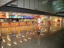
Porto Velho International Airport, 7 km from the city, has its main access at the Av. Governador Jorge Teixeira de Oliveira, with two lanes. Buses from downtown run to the airport every hour, and there is a fleet of taxis serving only the airport. The airport is served by 98 scheduled flights weekly, most going to other large Brazilian cities. The presence of Porto Velho Air Force Base ensures considerable movement of military aircraft. The local people refer to Porto Velho International as Belmont Airport because it is located in this district. It became an international airport in 2002. It was built as a replacement to Caiari Airport, which was closed on April 16, 1969.
Education
Portuguese is the official national language and primary language taught in schools, but English is part of the official high school curriculum.
Well-known Colleges
- Universidade Federal de Rondônia (Unir);
- Federal Institute of Education, Science and Technology of Rondônia - Instituto Federal de Educação, Ciência e Tecnologia de Rondônia (IFRO);
- Instituto Luterano de Ensino Superior de Porto Velho (Iles-Ulbra);
- Faculdade Interamericana de Porto Velho (Uniron);
- Faculdade de Ciências Administrativas e de Tecnologia (Fatec-RO);
- Faculdade de Ciências Humanas, Exatas e Letras de Rondônia (Faro);
- Faculdade da Amazônia (Iesa);
- Faculdade de Porto Velho/ Fundação Getúlio Vargas (FIP/FGV);
- Faculdades Integradas Maria Coelho Aguiar (FIMCA);
- Faculdade São Lucas;
Well-known Schools
- Maple Bear Canadian School
- Colégio Objetivo;
- Classe A;
- Escola Estadual de Ensino Fundamental e Médio João Bento da Costa;
- Colégio Tiradentes da Polícia Militar;
- Centro de Ensino Mineiro;
- Proensino;
- Instituto Laura Vicuña;
- Instituto Estadual de Educação Carmela Dutra;
- Colégio Dom Bosco
- Centro Educacional Dr Gilberto Mendes De Azevedo
- Instituto Maria Auxiliadora
Culture
Expovel
The Expovel is an agricultural event in Porto Velho.
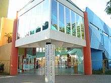
Museum
Madeira-Mamoré Railway Museum
References
- "Brazilian Institute of Geography and Statistics" (PDF) (in Portuguese). 2018. Retrieved 6 March 2019.
2018 Estimates of Population
- "Temperatura Média Compensada (°C)" (in Portuguese). Brazilian National Institute of Meteorology. 1961–1990. Archived from the original on August 8, 2014. Retrieved August 23, 2014.
- "Precipitação Acumulada Mensal e Anual (mm)" (in Portuguese). Brazilian National Institute of Meteorology. 1961–1990. Archived from the original on August 8, 2014. Retrieved August 23, 2014.
- "Temperatura Mínima Absoluta (ºC)". Brazilian National Institute of Meteorology (Inmet). Retrieved August 23, 2014.
- "Temperatura Máxima Absoluta (ºC)". Brazilian National Institute of Meteorology (Inmet). Retrieved August 23, 2014.
- "Temperatura Máxima (°C)" (in Portuguese). Brazilian National Institute of Meteorology. 1961–1990. Archived from the original on August 8, 2014. Retrieved August 23, 2014.
- "Temperatura Mínima (°C)" (in Portuguese). Brazilian National Institute of Meteorology. 1961–1990. Archived from the original on August 8, 2014. Retrieved August 23, 2014.
- "Número de Dias com Precipitação Mayor ou Igual a 1 mm (dias)". Brazilian National Institute of Meteorology. Archived from the original on August 27, 2014. Retrieved August 23, 2014.
- "Insolação Total (horas)". Brazilian National Institute of Meteorology. Archived from the original on August 8, 2014. Retrieved August 23, 2014.
- "Umidade Relativa do Ar Média Compensada (%)". Brazilian National Institute of Meteorology. Archived from the original on August 8, 2014. Retrieved August 23, 2014.
- Turner, I.M. 2001. The ecology of trees in the tropical rain forest. Cambridge University Press, Cambridge. ISBN 0-521-80183-4
- Amazon Rainforest, Amazon Plants, Amazon River Animals
- Millikan, Brent; Cardozo, Ivaneide Bandeira; Leroy, Jean Pierre; Caminha, Ludmila; Hargreaves, Maria Inês; Motta, Rogério Vargas; Alves, Vânia; Glass, Verena (June 2008), O Fim da Floresta? A Devastação das Unidades de Conservação e Terras Indígenas no Estado de Rondônia (PDF), Grupo de Trabalho Amazônico - GTA, retrieved 2016-09-05
- RESEX do Lago do Cuniã (in Portuguese), ISA: Instituto Socioambiental, retrieved 2016-09-03
- Unidade de Conservação: Estação Ecológica de Cuniã (in Portuguese), MMA: Ministério do Meio Ambiente, retrieved 2016-05-16
- "Estação Ecológica da Serra dos Três Irmãos", Via Rural (in Portuguese), retrieved 2016-05-24
- PARNA Mapinguari (in Portuguese), ISA: Instituto Socioambiental, retrieved 2016-06-02
- Unidade de Conservação: Floresta Nacional de Jacundá (in Portuguese), MMA: Ministério do Meio Ambiente, retrieved 2016-05-16
- RESEX Jaci Paraná (in Portuguese), ISA: Instituto Socioambiental, retrieved 2016-10-30
- Raupp de Matos, Valdir; Almeida, José, junior (7 November 1996), Decreto n.º 7635 de 07 de Novembro de 1996 (in Portuguese), retrieved 2016-10-30
- FLONA do Bom Futuro (in Portuguese), ISA: Instituto Socioambiental, retrieved 2016-10-30
- GDP (PDF) (in Portuguese). Porto Velho, Brazil: IBGE. 2005. ISBN 85-240-3919-1. Retrieved 2007-07-18.
- per capita income (PDF) (in Portuguese). Porto Velho, Brazil: IBGE. 2005. ISBN 85-240-3919-1. Retrieved 2007-07-18.
External links
- (in Portuguese) Prefeitura Municipal de Porto Velho (official page of Porto Velho)
- (in Portuguese) Unofficial page of Porto Velho history
- (in Portuguese) Twitter
- (in Portuguese) Facebook
Capital: Porto Velho | ||
| Alvorada d'Oeste |  | |
| Ariquemes | ||
| Cacoal | ||
| Colorado do Oeste | ||
| Guajara-Mirim | ||
| Ji-Parana | ||
| Porto Velho | ||
| Vilhena | ||
| Authority control |
|
|---|