Regional Municipality of Peel
The Regional Municipality of Peel (also known as the Region of Peel or Peel Region) is a regional municipality in Southern Ontario, Canada. It consists of three municipalities to the west and northwest of Toronto: the cities of Brampton and Mississauga, and the town of Caledon, each of which spans its full east-west width.[3] The entire region is part of the Greater Toronto Area and the inner ring of Golden Horseshoe. The regional seat is in Brampton.
Peel Region | |
|---|---|
Regional municipality (upper-tier) | |
| Regional Municipality of Peel | |
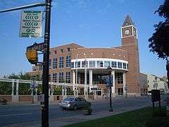
Clockwise: Mississauga, Cheltenham Badlands, Chinguacousy Park, Brampton City Hall, view of Lake Ontario and Toronto from Jack Darling Memorial Park | |
| Motto(s): Working for you | |
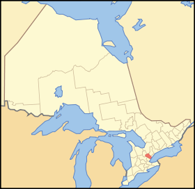 Map showing Peel Region's location in Ontario | |
| Coordinates: 43°37′N 79°37′W | |
| Country | Canada |
| Province | Ontario |
| Established | January 1, 1974 |
| Seat | Brampton |
| Government | |
| • Chair | Nando Iannicca |
| • Governing body | Peel Regional Council |
| Area | |
| • Total | 1,246.95 km2 (481.45 sq mi) |
| Population (2016)[2] | |
| • Total | 1,381,739 |
| • Density | 1,108/km2 (2,870/sq mi) |
| Time zone | UTC-5 (Eastern (EST)) |
| • Summer (DST) | UTC-4 (Eastern (EDT)) |
| Website | peelregion.ca |

.jpg)


With a population of 1,381,739[2] (2016 census), its growth can be credited largely to immigration and its transportation infrastructure: seven 400-series highways serve the region, and Toronto Pearson International Airport is located within its boundaries.
Mississauga occupies the southernmost portion of the region, and is, with 713,443 residents, the largest in population (the sixth-largest in Canada). It reaches from Lake Ontario north to near Highway 407. In the centre is Brampton, a city of 523,911 (ranked 9th by population in Canada). Finally up north, by far the largest in area and the most sparsely populated part of the region is Caledon, which is home to 59,460 residents.
History
.jpg)
The area was first settled in the early 1800s after being divided into townships in 1805; some of the townships came into existence later (to 1819). County of Peel was formed in 1851. It was named after Sir Robert Peel, the nineteenth-century Prime Minister of the United Kingdom.[4]
The townships that would eventually constitute Peel were initially part of York County in the Home District, and were designated as the West Riding of York in 1845.[5]
In 1867, Peel officially separated from York County. Peel county was dissolved in 1974.[6]
Brampton was virtually a village in 1834. The only building of consequence at the corner of Main (a renamed section of the historic Hurontario Street running between Port Credit and Collingwood) and Queen Streets, the recognized centre of Brampton, was William Buffy's tavern. In fact, at the time, the area was referred to as "Buffy's Corners". All real business in Chinguacousy Township took place one mile distant at Martin Salisbury's tavern. By 1834, John Elliott laid out the area in lots for sale, and applied the name "Brampton" to the area, which was soon adopted by others.[7]
The Region of Peel was created by the government of Bill Davis in 1974 from the former Peel County, and was legislated to provide community services to the (then) rapidly urbanizing area of south Peel County (now Mississauga and Brampton).
Government and politics
Senior administrators
- Nando Iannicca, Regional Chair
- Nancy Polsinelli, Interim Chief Administrative Officer
- Janice Sheehy, Commissioner of Human Services
- Kathryn Lockyer, Acting Commissioner of Corporate Services
- Janette Smith, Commissioner of Public Works
- Sean Baird, Commissioner of Digital and Information Services
- Cathy Granger, Acting Commissioner of Health Services
- Steven VanOfwegen, Commissioner of Finance and Chief Financial Officer
- Andrew Farr, Acting Commissioner of Public Works
Notable government decisions
- In 2005, Peel Region approved without tender a $557 million waste management contract commitment lasting 20 years that can potentially allow it to dump garbage in Ontario landfill sites if Michigan bans Canadian trash.[9]
- In 2004, Peel Region began a more than $600 million waterworks expansion by conducting invited public tenders, one of Canada's largest in water and wastewater infrastructure.[10]
Seat assignment controversy
Seats on Peel Regional council are not assigned to member municipalities according to population or tax contributions, and this has produced considerable controversy within the region.[11]
Mississauga currently comprises about 62 per cent of the region's population and says it contributes 66 per cent of the taxes, but had been assigned 10 of the 21 council seats (or 48 per cent) distributed among the municipalities, with Brampton receiving six and Caledon five. In June 2005, the provincial government passed legislation[12] that will revise the composition of the council. Beginning in the 2006 municipal elections, one additional seat will be assigned to Brampton and two additional seats will be assigned to Mississauga, giving Mississauga 12 of the 24 seats assigned to municipalities.[13] These numbers do not include the regional chair, who is appointed by council members.
These changes are the result of a provincially appointed impartial arbitrator who noted:[14]
Regional councilors, whether or not they also wear an area (local) hat, represent all taxpayers in that region...no one area municipality has a majority of regional councillors. This is also why Mississauga's claim for two more regional representatives was seen as vexing - Mississauga would then have a majority at the regional level. Mississauga magnified the control issue by complaining of a historic underrepresentation given that a majority of taxpayers in Peel reside and have resided within Mississauga .. [I] recommend a continuation of a structure that denies any one area municipality a majority at the region.
— George W. Adams
Mississauga council, led by former mayor Hazel McCallion, has argued that Peel Region is an unnecessary layer of government which costs Mississauga residents millions of dollars a year to support services in Brampton and Caledon. Mississauga council unanimously passed a motion asking the Province of Ontario to separate Mississauga from Peel Region and become a single-tier municipality, arguing, among other things, the need to keep property tax dollars within the city of Mississauga for the good of the future of the City.[15]
Opponents of Mississauga's position, including former Brampton mayor Susan Fennell, have argued that from the 1970s through the 1990s, Mississauga was the chief beneficiary of Peel's infrastructure construction projects — funded by taxpayers in all three municipalities — and it is now Brampton's turn to benefit, as it is growing faster than Mississauga, which is mostly built-out.[16][17] As well, they have argued that common infrastructure, such as waste and water services, would be more efficiently managed at a regional level.
Climate
Factors that influence the climate
The region's climate are influenced by various air masses and weather systems from other locations, proximity to Lake Ontario, topography and elevation (e.g. Niagara Escarpment, and Oak Ridges Moraine), and urban and rural land uses.[18]:36 The air masses and weather systems are the major factors in influencing the climate of the region.[18]:36 Being located in Southern Ontario, it is located between the Arctic, subtropics, and the Atlantic Ocean; consequentially, it is impacted by air masses from different origins.[18]:37 In general, the air masses that affect the region are continental polar, continental arctic, maritime polar, and occasionally continental tropical air masses in summer.[18]:37 During winter, cold and dry air masses predominate (continental arctic and maritime polar) although warmer, moister air masses may move north during this time, leading to milder temperatures and potential for heavy snowfall/freezing rain/rainfall.[18]:38 The most severe snow and freezing rain events occur when warmer, moister air masses move northward to the region and meet colder air.[18]:38 During winter, a common type of storm is known as the "Alberta Clipper" which affects the region in which moist Pacific air moves east of the Rocky Mountains to the region, bringing snow that is often followed by the influx of cold continental air afterwards (leads to colder temperatures).[18]:38 Spring and autumn are characterized by variable weather and rapid alternating air masses.[18]:38 This leads to frequent cloudy conditions, rain, and occasional thunderstorms.[18]:38 In summer, the air masses that influence the region are predominantly maritime polar air masses from the Pacific Ocean, and tropical air masses from the Gulf of Mexico, the latter being responsible for bringing heat waves, high humidity, and intense rainfall events.[18]:38 Towards late summer and early autumn, tropical storms and remnants of hurricanes may bring strong winds and heavy rainfalls to the area.[18]:38 During autumn, Arctic air masses become increasingly common, leading to colder conditions.[18]:38
The Great Lakes (particularly Lake Ontario) moderate the cooler air masses during autumn and winter, causing the region to have milder conditions than similar areas away from the Lakes.[18]:38 Because the Great Lakes are slower to warm than the land, they keep shoreline areas cooler in spring, leading to prolonged cool weather that persists well into April.[18]:39 The prolonged cool conditions on the shoreline causes the leafing and blossoming of the plants to be delayed, which protects tender plants such as fruit trees from being damaged by late spring frosts.[18]:39 Thus, plants from more warmer climates are able to survive on the shoreline due to this.[18]:39 Occasionally, temperature inversions can occur, particularly in spring and early summer.[18]:39 Temperature inversions occur when warm, moist air from the Gulf of Mexico moves pass the Great Lakes because while the top layers of the Lakes are warmed, the bottom layers remain cool, leading to moisture and airborne pollutants being trapped in the cool air below, humid days, and causing fog,haze, and smog in low laying industrial areas.[18]:39 The Great Lakes also stabilize conditions in spring and summer (due to the relatively cooler lake surfaces), leading to lower spring and summer precipitation on their shorelines compared to inland areas.[18]:38 In winter, Lake effect snowfall occurs.[18]:38 In spring and summer, lake breezes can penetrate inland, creating narrow boundaries more inland causing cloudy conditions, severe thunderstorms, and convective rainfall events.[18]:38 This is known as the "lake breeze front" or "lake breeze thunderstorms" phenomenon, in which intense, sharply defined squall lines develop quickly on summer afternoons amplified by localized wind patterns between the Great Lakes.[19] This is seen by the tendency for thunderstorms from the west to weaken/dissipate as they approach Toronto Pearson Airport, located in the southeastern part of the region.[18]:38
Temperature
Temperatures are higher in the southern parts of Peel compared to the northern parts of the region.[18]:42 Annual temperatures are −3 °C (−5 °F) warmer in the south than in the northern parts of the region.[18]:42 This is due to the lower elevations found in the southern parts of the region, the moderating effects of Lake Ontario, and more urbanization in the south (due to the urban heat island effect).[18]:42 In colder months, areas closer to Lake Ontario are warmer while in summer, the same areas are colder owing to the moderating effect of the Lake.[18]:42
Precipitation
Generally, the northwestern parts of Peel region are the wettest areas both seasonally and annually while southern parts are the driest.[18]:55 Mean annual precipitation in the region ranges from 835 to 935 mm (32.9 to 36.8 in) in the northwest to 794 to 836 mm (31.3 to 32.9 in) in Mississauga in the south.[18]:55 The north-south precipitation gradient is primiarly due to topographic and elevation differences, and some regional storm track differences.[18]:55 The regional storm track differences include the influence of the Great Lakes on summertime convective precipitation, northernmost extent to where tropical air progresses in winter, and positions of frontal zones in spring and autumn).[18]:55 These regional storm track differences are responsible for a slight rain shadow effect for most of Peel except for the northern parts which lie on the windward side and receive more precipitation from frontal systems moving from the west.[18]:55 In all seasons, precipitation mostly comes from low pressure systems from the mid-Atlantic states and Gulf of Mexico.[18]:55
Statistics
| Month | Jan | Feb | Mar | Apr | May | Jun | Jul | Aug | Sep | Oct | Nov | Dec | Year |
|---|---|---|---|---|---|---|---|---|---|---|---|---|---|
| Record high humidex | 19.0 | 14.8 | 29.2 | 37.9 | 42.6 | 45.0 | 50.3 | 46.6 | 48.0 | 39.1 | 28.6 | 23.9 | 50.3 |
| Record high °C (°F) | 17.6 (63.7) |
17.7 (63.9) |
26.0 (78.8) |
31.1 (88.0) |
34.4 (93.9) |
36.7 (98.1) |
37.6 (99.7) |
38.3 (100.9) |
36.7 (98.1) |
31.6 (88.9) |
25.0 (77.0) |
20.0 (68.0) |
38.3 (100.9) |
| Average high °C (°F) | −1.5 (29.3) |
−0.4 (31.3) |
4.6 (40.3) |
12.2 (54.0) |
18.8 (65.8) |
24.2 (75.6) |
27.1 (80.8) |
26.0 (78.8) |
21.6 (70.9) |
14.3 (57.7) |
7.6 (45.7) |
1.4 (34.5) |
13.0 (55.4) |
| Daily mean °C (°F) | −5.5 (22.1) |
−4.5 (23.9) |
0.1 (32.2) |
7.1 (44.8) |
13.1 (55.6) |
18.6 (65.5) |
21.5 (70.7) |
20.6 (69.1) |
16.2 (61.2) |
9.5 (49.1) |
3.7 (38.7) |
−2.2 (28.0) |
8.2 (46.8) |
| Average low °C (°F) | −9.4 (15.1) |
−8.7 (16.3) |
−4.5 (23.9) |
1.9 (35.4) |
7.4 (45.3) |
13.0 (55.4) |
15.8 (60.4) |
15.1 (59.2) |
10.8 (51.4) |
4.6 (40.3) |
−0.2 (31.6) |
−5.8 (21.6) |
3.3 (37.9) |
| Record low °C (°F) | −31.3 (−24.3) |
−31.1 (−24.0) |
−28.9 (−20.0) |
−17.2 (1.0) |
−5.6 (21.9) |
0.6 (33.1) |
3.9 (39.0) |
1.1 (34.0) |
−3.9 (25.0) |
−8.3 (17.1) |
−18.3 (−0.9) |
−31.1 (−24.0) |
−31.3 (−24.3) |
| Record low wind chill | −44.7 | −38.9 | −36.2 | −25.4 | −9.5 | 0.0 | 0.0 | 0.0 | −8.0 | −13.5 | −25.4 | −38.5 | −44.7 |
| Average precipitation mm (inches) | 51.8 (2.04) |
47.7 (1.88) |
49.8 (1.96) |
68.5 (2.70) |
74.3 (2.93) |
71.5 (2.81) |
75.7 (2.98) |
78.1 (3.07) |
74.5 (2.93) |
61.1 (2.41) |
75.1 (2.96) |
57.9 (2.28) |
785.9 (30.94) |
| Average rainfall mm (inches) | 25.1 (0.99) |
24.3 (0.96) |
32.6 (1.28) |
63.0 (2.48) |
74.3 (2.93) |
71.5 (2.81) |
75.7 (2.98) |
78.1 (3.07) |
74.5 (2.93) |
60.6 (2.39) |
68.0 (2.68) |
34.0 (1.34) |
681.6 (26.83) |
| Average snowfall cm (inches) | 29.5 (11.6) |
24.0 (9.4) |
17.7 (7.0) |
4.5 (1.8) |
0.02 (0.01) |
0.0 (0.0) |
0.0 (0.0) |
0.0 (0.0) |
0.0 (0.0) |
0.4 (0.2) |
7.5 (3.0) |
24.9 (9.8) |
108.5 (42.7) |
| Average precipitation days (≥ 0.2 mm) | 15.1 | 11.6 | 12.4 | 12.5 | 12.5 | 10.8 | 10.4 | 10.2 | 10.5 | 12.1 | 13.2 | 14.8 | 145.9 |
| Average rainy days (≥ 0.2 mm) | 5.4 | 4.6 | 7.4 | 11.3 | 12.5 | 10.8 | 10.4 | 10.2 | 10.5 | 12.0 | 11.0 | 7.1 | 113.2 |
| Average snowy days (≥ 0.2 cm) | 12.1 | 9.4 | 6.8 | 2.4 | 0.03 | 0.0 | 0.0 | 0.0 | 0.0 | 0.3 | 3.4 | 10.0 | 44.4 |
| Average relative humidity (%) (at 15:00) | 72.0 | 68.4 | 61.4 | 54.4 | 53.5 | 54.9 | 53.3 | 55.8 | 58.5 | 62.1 | 69.2 | 72.5 | 61.3 |
| Mean monthly sunshine hours | 79.7 | 112.2 | 159.4 | 204.4 | 228.2 | 249.7 | 294.4 | 274.5 | 215.7 | 163.7 | 94.2 | 86.2 | 2,161.4 |
| Percent possible sunshine | 27.6 | 38.0 | 43.2 | 50.8 | 50.1 | 54.1 | 63.0 | 63.4 | 57.4 | 47.8 | 32.0 | 30.9 | 46.5 |
| Source: Environment Canada[20][21][22][23] | |||||||||||||
| Climate data for Albion Field Centre 1981–2010 (Albion Township and Caledon) | |||||||||||||
|---|---|---|---|---|---|---|---|---|---|---|---|---|---|
| Month | Jan | Feb | Mar | Apr | May | Jun | Jul | Aug | Sep | Oct | Nov | Dec | Year |
| Record high °C (°F) | 12.0 (53.6) |
14.5 (58.1) |
24.5 (76.1) |
30.0 (86.0) |
33.0 (91.4) |
34.5 (94.1) |
36.1 (97.0) |
35.0 (95.0) |
34.4 (93.9) |
30.6 (87.1) |
22.2 (72.0) |
19.5 (67.1) |
36.1 (97.0) |
| Average high °C (°F) | −2.8 (27.0) |
−1.4 (29.5) |
3.7 (38.7) |
11.6 (52.9) |
18.8 (65.8) |
23.7 (74.7) |
26.3 (79.3) |
25.1 (77.2) |
19.9 (67.8) |
13.2 (55.8) |
5.8 (42.4) |
−0.3 (31.5) |
12.0 (53.6) |
| Daily mean °C (°F) | −7.0 (19.4) |
−5.9 (21.4) |
−1.4 (29.5) |
6.1 (43.0) |
12.4 (54.3) |
17.3 (63.1) |
19.9 (67.8) |
19.1 (66.4) |
14.3 (57.7) |
8.1 (46.6) |
2.1 (35.8) |
−3.9 (25.0) |
6.7 (44.1) |
| Average low °C (°F) | −11.2 (11.8) |
−10.4 (13.3) |
−6.6 (20.1) |
0.5 (32.9) |
5.9 (42.6) |
10.9 (51.6) |
13.5 (56.3) |
13.0 (55.4) |
8.6 (47.5) |
2.9 (37.2) |
−1.7 (28.9) |
−7.4 (18.7) |
1.5 (34.7) |
| Record low °C (°F) | −36.5 (−33.7) |
−35.0 (−31.0) |
−31.5 (−24.7) |
−21.1 (−6.0) |
−6.1 (21.0) |
−1.5 (29.3) |
1.7 (35.1) |
−0.5 (31.1) |
−5.0 (23.0) |
−11.5 (11.3) |
−19.0 (−2.2) |
−32.0 (−25.6) |
−36.5 (−33.7) |
| Average precipitation mm (inches) | 60.4 (2.38) |
50.2 (1.98) |
50.3 (1.98) |
67.0 (2.64) |
76.1 (3.00) |
75.5 (2.97) |
81.8 (3.22) |
77.4 (3.05) |
75.0 (2.95) |
68.3 (2.69) |
81.7 (3.22) |
57.7 (2.27) |
821.5 (32.34) |
| Average rainfall mm (inches) | 24.0 (0.94) |
22.2 (0.87) |
27.3 (1.07) |
63.0 (2.48) |
76.1 (3.00) |
75.5 (2.97) |
81.8 (3.22) |
77.4 (3.05) |
75.0 (2.95) |
64.9 (2.56) |
67.8 (2.67) |
25.9 (1.02) |
681.0 (26.81) |
| Average snowfall cm (inches) | 36.4 (14.3) |
28.0 (11.0) |
23.0 (9.1) |
4.0 (1.6) |
0.0 (0.0) |
0.0 (0.0) |
0.0 (0.0) |
0.0 (0.0) |
0.0 (0.0) |
3.4 (1.3) |
13.8 (5.4) |
31.9 (12.6) |
140.5 (55.3) |
| Average precipitation days (≥ 0.2 mm) | 12.4 | 9.4 | 9.6 | 10.8 | 10.3 | 10.2 | 9.0 | 9.8 | 10.8 | 11.3 | 12.1 | 9.8 | 125.5 |
| Average rainy days (≥ 0.2 mm) | 3.3 | 3.6 | 5.2 | 9.9 | 10.3 | 10.2 | 9.0 | 9.8 | 10.8 | 11.2 | 9.3 | 3.7 | 96.2 |
| Average snowy days (≥ 0.2 cm) | 9.8 | 6.4 | 5.3 | 1.4 | 0.1 | 0.0 | 0.0 | 0.0 | 0.0 | 0.6 | 4.0 | 6.8 | 34.3 |
| Source: Environment Canada[24] | |||||||||||||
Services
The region is responsible for the services and infrastructure related to water delivery and wastewater treatment, waste collection and disposal, some arterial roads, public health, long-term care centres, Peel Regional Police, Peel Regional Paramedic Services, planning, public housing, paratransit, judicial and social services. Other municipal functions are provided by the three local-tier municipalities. These responsibilities have changed over time, as functions have been uploaded and downloaded to and from the provincial and regional levels, as directed by the Government of Ontario.
Law enforcement
- Peel Regional Police (PRP) provides police coverage for the majority of the region excluding Caledon as well as airport policing within Toronto Pearson International Airport (replaced the RCMP)
- Ontario Provincial Police (OPP) mainly provides policing on:
- Provincial highways (400 series): QEW - Winston Churchill Boulevard to Etobicoke Creek; Highway 401 - from Ninth Line to Highway 427; Highway 403 - from Dundas Street to Highways 410/401; Highway 409 - from Toronto-Pearson International Airport to Highway 427; Highway 410 - from Highway 403 to Highway 10 transition; (Other King's Highways): Highway 9 - from Highway 10 to Albion Trail; Highway 10 - from Highway 410 transition to Highway 9.
- Patrols privately operated Highway 407 ETR from Highway 403 to Regional Road 50
- Fulfils a contract to police the town of Caledon.[25]
Education
Education in the Region of Peel is primarily available from taxpayer-funded public schools (secular) and separate schools (Catholic) in both the English and French languages.
Schools in Peel are managed by four school boards: the Peel District School Board (English public), the Dufferin-Peel Catholic District School Board (English separate), the Conseil scolaire Viamonde (French public), and the Conseil scolaire de district catholique Centre-Sud (French separate).
Other services
Emergency medical services provided by Peel to the region's municipalities:
Peel Regional Paramedic Services
Formerly administered by the province, now in the hands of the region.
Long Term Care
Facilities are for seniors and others with long term health needs:
- The Davis Centre
- Malton Village
- Peel Manor
- Sheridan Villa
- Tall Pines
Social Housing
Peel is the largest landlord in the Region. Its non-profit housing company, Peel Living, is one of the largest in Canada.[26]
Public Works
Peel manages the regions public works needs including:
- garbage and recycling programs
- water works
- road maintenance for many major roads — non-provincial roads
TransHelp
The Region of Peel's unique transportation service for people with disabilities, Transhelp was formerly run for Miway and Brampton Transit but is now operated solely by the Region. Convention transit is still operated by the aforementioned transit systems.
Shopping
Major indoor shopping centres located in Peel Region include:
- Bramalea City Centre (Brampton)
- Shoppers World Brampton (Brampton)
- Square One Shopping Centre (Mississauga)
- Erin Mills Town Centre (Mississauga)
- Dixie Outlet Mall (Mississauga)
Major outdoor centres located in Peel Region include:
- Heartland Town Centre (Mississauga)
- Trinity Common (Brampton)
Highways
Seven 400-Series Highways border or pass through Peel Region. These freeways are among the busiest and most modern of Ontario, mostly constructed since the 1970s, and have contributed significantly to the rapid growth of the Region. One of the welcome signs of Brampton has the slogan "All roads lead to Brampton" and shows six 400-series numbers (401, 403, 407, 409, 410, 427).
400-series freeways
Other highways
- Highway 9, which forms the northern boundary of the region
- Highway 10
- Highway 50 which forms the Eastern boundary of the region (Vaughan)
Demographics
| Ethnic groups in Peel (2016) Source: | Population | % | |
|---|---|---|---|
| Ethnic group | European | 514,265 | 37.5% |
| South Asian | 434,105 | 31.6% | |
| Black | 131,060 | 9.5% | |
| Chinese | 63,745 | 4.6% | |
| Filipino | 57,205 | 4.2% | |
| Arab | 42,500 | 3.1% | |
| Latin American | 31,060 | 2.3% | |
| Southeast Asian | 23,415 | 1.7% | |
| Aboriginal | 14,265 | 1% | |
| West Asian | 13,435 | 1% | |
| Korean | 6,630 | 0.5% | |
| Japanese | 2,595 | 0.2% | |
| Visible minority, n.i.e. | 25,470 | 1.9% | |
| Multiple minorities | 23,335 | 1.7% | |
| Total population | 1,381,739 | 100% | |
According to the 2011 Census, 57% of Peel's population was Christian, 10% was Sikh, 10% was Muslim, 9% was Hindu, 3% belonged to other faiths and 13% had no religious affiliation.[27]
According to the 2011 Census, 50.61% of Peel's population have English as mother tongue; Punjabi is the mother tongue of 8.92% of the population, followed by Urdu (3.84%), Polish (2.68%), Portuguese (2.29%), Tagalog (2.24%), Italian (2.09%), Spanish (2.08%), Arabic (1.96%), and Hindi (1.50%).[28]
| Mother tongue | Population | Percentage |
|---|---|---|
| English | 653,555 | 50.61% |
| Punjabi | 115,200 | 8.92% |
| Urdu | 49,550 | 3.84% |
| Polish | 34,585 | 2.68% |
| Portuguese | 29,620 | 2.29% |
| Tagalog (Filipino) | 28,875 | 2.24% |
| Italian | 27,015 | 2.09% |
| Spanish | 26,835 | 2.08% |
| Arabic | 25,270 | 1.96% |
| Hindi | 19,375 | 1.50% |
| Canada census – Regional Municipality of Peel community profile | |||
|---|---|---|---|
| 2011 | 2006 | ||
| Population: | 1,296,814 (11.8% from 2006) | 1,159,405 (17.2% from 2001) | |
| Land area: | 1,246.89 km2 (481.43 sq mi) | 1,242.40 km2 (479.69 sq mi) | |
| Population density: | 1,040.0/km2 (2,694/sq mi) | 933.2/km2 (2,417/sq mi) | |
| Median age: | 35.6 (M: 35.0, F: 36.1) | ||
| Total private dwellings: | 416,850 | 373,455 | |
| Median household income: | $72,655 | ||
| References: 2011[29] 2006[30] earlier[31] | |||
See also
References
- "(Code 3521) Census Profile". 2011 census. Statistics Canada. 2012. Retrieved 2012-03-01.
- https://www12.statcan.gc.ca/census-recensement/2016/dp-pd/prof/details/page.cfm?Lang=E&Geo1=CD&Code1=3521&Geo2=CD&Code2=3521&Data=Count&SearchText=Mississauga&SearchType=Begins&SearchPR=01&B1=Population
- "Regional Municipality of Peel (scanned map)". Map 21-6 [Southern Ontario]. Survey and Mapping Branch, Ministry of Natural Resources, Government of Ontario Canada. 1980. Archived from the original on 2010-05-28. Retrieved 2010-02-01.
- "That Name "PEEL" -- Where Did We Get It ?". A history of the Peel county: to mark its centenary. Brampton ON: County of Peel. 1967.
- An Act for better defining the limits of the Counties and Districts in Upper Canada, for erecting certain new Townships, for detaching Townships from some Counties and attaching them to others, and for other purposes relative to the division of Upper Canada into Townships, Counties and Districts, S.Prov.C. 1845, c. 7, Sch. B
- https://peelarchivesblog.com/about-peel/, The History of Peel Region, Ontario, Canada
- "Brampton's Beginning" in Brampton's 100th Anniversary as an Incorporated Town: 1873-1973, Brampton: The Corporation of the Town of Brampton and the Brampton Centennial Committee, 1973, originally published in Ross Cumming, ed., Historical Atlas of Peel County, n.p.: Walker and Miles, 1877.
- "Executive Management Team". Region of Peel website. Region of Peel, Ontario Canada. Archived from the original on 2006-08-13. Retrieved 2006-07-05.
- Toronto Star, October 21, 2005
- Brampton Guardian, July 7, 2004
- ontla.on.ca
- "Regional Municipality of Peel Act, 2005". S.O. 2005, c. 20. Canadian Legal Information Institute. 2005. Retrieved 2006-07-05.
- "Peel Residents To Get Fairer Regional Representation" (Press release). Ontario Ministry of Municipal Affairs and Housing. 2005-06-13. Retrieved 2006-07-05.
- "Regional Municipality of Peel Act, 2005 S.o. 2005, chapter 20". Archived from the original on 2005-11-18.
- "Mayor's Update" (Press release). City of Mississauga, Ontario Canada. April 2004. Archived from the original on 2007-09-26. Retrieved 2006-07-07..
- "House Proceeding: Regional Municipality of Peel Act, 2005". 18:50 - 19:00. Debates of the Legislative Assembly of Ontario. Legislative Assembly of Ontario. 2005-04-26. Retrieved 2006-07-07.
- Divell, Sabrina (2005-04-01). "Region will grind to a halt: Mayor". Brampton Guardian. p. 01. Archived from the original on 2006-09-06. Retrieved 2006-07-07.
- Auld, Heather; Switzman, Harris; Comer, Neil; Eng, Simon; Hazen, Shelley; Milner, Glenn (February 2016). "Climate Trends and Future Projections in the Region of Peel" (PDF). Ontario Climate Consortium. Archived from the original (PDF) on 16 June 2019. Retrieved 16 June 2019.
- "Lake Breeze Weather". Archived from the original on 4 March 2016.
- "Toronto Lester B. Pearson International Airport". 1981-2010 Canadian Climate Normals. Environment Canada. Retrieved 2013-07-10.
- "Toronto Lester B. Pearson INT'L A". Canadian Climate Normals 1981–2010. Environment Canada. Retrieved June 3, 2014.
- "Daily Data Report for February 2017". Environment Canada. Retrieved March 29, 2017.
- "Daily Data Report for March 2012". Retrieved November 25, 2018.
- "Albion Field Centre". 1981-2010 Canadian Climate Normals. Environment Canada. Retrieved 2016-05-12.
- Regional Municipality of Peel Services Police Board website Archived 2006-09-08 at the Wayback Machine on the division of policing between the OPP and Peel Regional Police.
- "Housing - Peel Living". Regional Municipality of Peel, Ontario Canada. 2007. Retrieved 2007-07-05.
- "2011 NHS Bulletin" (PDF).
- Census Profile Peel, RM (Ontario)
- "2011 Community Profiles". 2011 Canadian Census. Statistics Canada. July 5, 2013. Retrieved 2012-02-08.
- "2006 Community Profiles". 2006 Canadian Census. Statistics Canada. March 30, 2011. Retrieved 2012-02-02.
- "2001 Community Profiles". 2001 Canadian Census. Statistics Canada. February 17, 2012.
Further reading
- Region of Peel fonds at the Peel Art Gallery, Museum and Archives
External links
| Wikimedia Commons has media related to Regional Municipality of Peel. |
Places adjacent to Regional Municipality of Peel | ||||||||||
|---|---|---|---|---|---|---|---|---|---|---|
| ||||||||||
Largest city: Toronto | ||
| Regions | 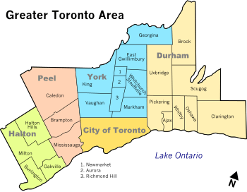 | |
| Cities | ||
| Towns | ||
| Townships and municipalities | ||
| Regions | |
|---|---|
| Counties | |
| Districts | |
| Regional municipalities | |
| Single-tier municipalities | |
| Separated municipalities | |
| |
| Authority control |
|
|---|