Caledon, Ontario
Caledon (2016 population 66,502) is a town in the Regional Municipality of Peel in the Greater Toronto Area of Ontario, Canada. From a shortened form of Caledonia, the Roman name for North Britain; Caledon is a developing urban area although it remains primarily rural.[4] It consists of an amalgamation of a number of urban areas, villages, and hamlets; its major urban centre is Bolton on its eastern side adjacent to York Region.
Caledon | |
|---|---|
| Town of Caledon | |
 Highway 10 through Caledon | |
 Flag | |
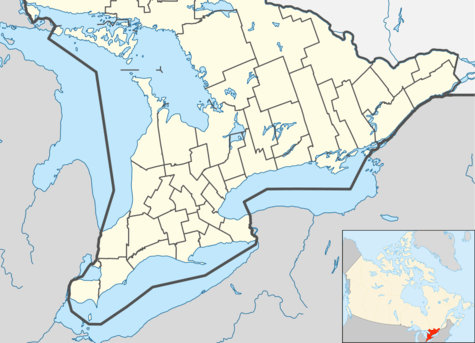 Caledon Caledon's location within southern Ontario | |
| Coordinates: 43°52′N 79°52′W | |
| Country | Canada |
| Province | Ontario |
| Regional municipality | Peel Region |
| Established | January 1, 1974 |
| Government | |
| • Type | Town |
| • Mayor | Allan Thompson (List) |
| • Governing Body | Caledon Town Council |
| • MP | Kyle Seeback (CPC) |
| • MPP | Sylvia Jones (PC) |
| Area | |
| • Land | 688.15 km2 (265.70 sq mi) |
| Highest elevation | 485 m (1,591 ft) |
| Lowest elevation | 221 m (725 ft) |
| Population (2016)[1] | |
| • Total | 66,502 |
| • Density | 96.6/km2 (250/sq mi) |
| Time zone | UTC-5 (EST) |
| • Summer (DST) | UTC-4 (EDT) |
| Forward sortation area | L7C, L7K |
| Area code(s) | 905, 519 |
| Website | www.caledon.ca |
Caledon is one of three municipalities of Peel Region. The town is at the northwest border of the city of Brampton. At over 688 km², Caledon is the largest city or town by area in the Greater Toronto Area.
History
By 1869, Belfountain was a Village with a population of 100 in the Township of Caledon County Peel. It was established on the Credit River. There were stagecoaches to Erin and Georgetown. The average price of land was $20.[5]
In 1973 Caledon acquired more territory when Chinguacousy dissolved with most sections north of Mayfield Road (excluding Snelgrove) transferred to the township.
Caledon inherited the name from Caledon Township of then Peel County, Ontario in 1974, which was likely named by settlers, like Edward Ellis (who came from the area around Caledon, County Tyrone in Northern Ireland) or by public voting.[6]
Demographics
According to the 2016 Canadian Census[7] the population of Caledon is 66,503, an 11.8% increase from 2011. The population density is 96.6 people per square km. The median age is 41 years old, basically on par with the national median at 41.2 years old.[8] The top three ethnic origins are Italian (27.3%), English (21.1%) and Canadian (19.7%).[7] There are 21,255 private dwellings. According to the 2011 National Household Survey, the median value of a dwelling in Caledon is $474,087 which is significantly higher than the national average at $280,552. The median household income (after-taxes) in Caledon is $83,454, much higher than the national average at $54,089. The average individual's income is $53,870.[7]
In 2011, Caledon's largest religious groups were: 77.5% Christian, 18.6% no religious affiliation and 2% Sikh. There were also smaller numbers of Hindu, Jewish, Muslim and Buddhist residents.[9]
| Historical populations | ||
|---|---|---|
| Year | Pop. | ±% |
| 1981 | 26,645 | — |
| 1991 | 34,965 | +31.2% |
| 1996 | 39,893 | +14.1% |
| 2001 | 50,595 | +26.8% |
| 2006 | 57,050 | +12.8% |
| 2011 | 59,460 | +4.2% |
| 2016 | 66,502 | +11.8% |
| Source: Statistics Canada | ||
| Canada 2016 Census | Population | % of total population | |
|---|---|---|---|
| Visible minority group Source:[10] |
South Asian | 6,635 | 10% |
| Black | 1,880 | 2.8% | |
| Latin American | 905 | 1.4% | |
| Chinese | 695 | 1% | |
| Filipino | 535 | 0.8% | |
| Arab | 250 | 0.4% | |
| Mixed and other visible minority | 2,110 | 3.2% | |
| Total visible minority population | 12,410 | 18.8% | |
| Aboriginal group Source:[10] |
First Nations | 370 | 0.6% |
| Métis | 215 | 0.3% | |
| Inuit | 20 | 0% | |
| Total Aboriginal population | 615 | 0.9% | |
| European | 53,195 | 80.3% | |
| Total population | 66,220 | 100% | |
Languages
According to the 2011 Census, 76.8% of the town's population spoke English as their mother tongue. Other common mother tongues included Italian (8.1% of the population), followed by Punjabi (1.6%), Portuguese (1.4%), German (1.3%), Polish (1.2%) and Spanish (1.2%).[11]
| Mother tongue | Population | Percentage |
|---|---|---|
| English | 45,490 | 76.83% |
| Italian | 4,815 | 8.13% |
| Punjabi | 975 | 1.65% |
| Portuguese | 840 | 1.42% |
| German | 765 | 1.29% |
| Polish | 740 | 1.25% |
| Spanish | 725 | 1.22% |
| French | 580 | 0.98% |
| Croatian | 310 | 0.52% |
| Greek | 230 | 0.39% |
Government
_(cropped).jpg)
Caledon is divided into five wards represented on town council by:[12]
- Mayor Allan Thompson
- Area Councillor Ward 1 Lynn Kiernan
- Area Councillor Ward 2 Christina Early
- Area Councillor Ward 3 & 4 Nick deBoer
- Area Councillor Ward 5 Tony Rosa
and on regional council by:[12]
- Mayor Allan Thompson
- Regional Councillor Ward 1 Ian Sinclair
- Regional Councillor Ward 2 Johanna Downey
- Regional Councillor Ward 3 & 4 Jennifer Innis
- Regional Councillor Ward 5 Annette Groves
Per capita, Caledon has by far the largest representation on Peel Regional Council among the three municipalities.
Climate
| Climate data for Albion Field Centre 1981–2010 (Albion Township and Caledon) | |||||||||||||
|---|---|---|---|---|---|---|---|---|---|---|---|---|---|
| Month | Jan | Feb | Mar | Apr | May | Jun | Jul | Aug | Sep | Oct | Nov | Dec | Year |
| Record high °C (°F) | 12.0 (53.6) |
14.5 (58.1) |
24.5 (76.1) |
30.0 (86.0) |
33.0 (91.4) |
34.5 (94.1) |
36.1 (97.0) |
35.0 (95.0) |
34.4 (93.9) |
30.6 (87.1) |
22.2 (72.0) |
19.5 (67.1) |
36.1 (97.0) |
| Average high °C (°F) | −2.8 (27.0) |
−1.4 (29.5) |
3.7 (38.7) |
11.6 (52.9) |
18.8 (65.8) |
23.7 (74.7) |
26.3 (79.3) |
25.1 (77.2) |
19.9 (67.8) |
13.2 (55.8) |
5.8 (42.4) |
−0.3 (31.5) |
12.0 (53.6) |
| Daily mean °C (°F) | −7.0 (19.4) |
−5.9 (21.4) |
−1.4 (29.5) |
6.1 (43.0) |
12.4 (54.3) |
17.3 (63.1) |
19.9 (67.8) |
19.1 (66.4) |
14.3 (57.7) |
8.1 (46.6) |
2.1 (35.8) |
−3.9 (25.0) |
6.7 (44.1) |
| Average low °C (°F) | −11.2 (11.8) |
−10.4 (13.3) |
−6.6 (20.1) |
0.5 (32.9) |
5.9 (42.6) |
10.9 (51.6) |
13.5 (56.3) |
13.0 (55.4) |
8.6 (47.5) |
2.9 (37.2) |
−1.7 (28.9) |
−7.4 (18.7) |
1.5 (34.7) |
| Record low °C (°F) | −36.5 (−33.7) |
−35.0 (−31.0) |
−31.5 (−24.7) |
−21.1 (−6.0) |
−6.1 (21.0) |
−1.5 (29.3) |
1.7 (35.1) |
−0.5 (31.1) |
−5.0 (23.0) |
−11.5 (11.3) |
−19.0 (−2.2) |
−32.0 (−25.6) |
−36.5 (−33.7) |
| Average precipitation mm (inches) | 60.4 (2.38) |
50.2 (1.98) |
50.3 (1.98) |
67.0 (2.64) |
76.1 (3.00) |
75.5 (2.97) |
81.8 (3.22) |
77.4 (3.05) |
75.0 (2.95) |
68.3 (2.69) |
81.7 (3.22) |
57.7 (2.27) |
821.5 (32.34) |
| Average rainfall mm (inches) | 24.0 (0.94) |
22.2 (0.87) |
27.3 (1.07) |
63.0 (2.48) |
76.1 (3.00) |
75.5 (2.97) |
81.8 (3.22) |
77.4 (3.05) |
75.0 (2.95) |
64.9 (2.56) |
67.8 (2.67) |
25.9 (1.02) |
681.0 (26.81) |
| Average snowfall cm (inches) | 36.4 (14.3) |
28.0 (11.0) |
23.0 (9.1) |
4.0 (1.6) |
0.0 (0.0) |
0.0 (0.0) |
0.0 (0.0) |
0.0 (0.0) |
0.0 (0.0) |
3.4 (1.3) |
13.8 (5.4) |
31.9 (12.6) |
140.5 (55.3) |
| Average precipitation days (≥ 0.2 mm) | 12.4 | 9.4 | 9.6 | 10.8 | 10.3 | 10.2 | 9.0 | 9.8 | 10.8 | 11.3 | 12.1 | 9.8 | 125.5 |
| Average rainy days (≥ 0.2 mm) | 3.3 | 3.6 | 5.2 | 9.9 | 10.3 | 10.2 | 9.0 | 9.8 | 10.8 | 11.2 | 9.3 | 3.7 | 96.2 |
| Average snowy days (≥ 0.2 cm) | 9.8 | 6.4 | 5.3 | 1.4 | 0.1 | 0.0 | 0.0 | 0.0 | 0.0 | 0.6 | 4.0 | 6.8 | 34.3 |
| Source: Environment Canada[13] | |||||||||||||
Education
The Peel District School Board operates secular Anglophone schools. The Dufferin-Peel Catholic District School Board operates Catholic Anglophone separate schools. The Conseil scolaire Viamonde operates secular Francophone schools serving the area. The Conseil scolaire de district catholique Centre-Sud operates Catholic Francophone schools serving the area.
School (Location)
- Allan Drive Middle School (Bolton)
- Alloa Public School (Caledon)
- Alton Public School (Alton)
- Belfountain Public School (Belfountain)
- Brampton Christian School (Private)
- Caledon Central Public School (Caledon Village)
- Caledon East Public School (Caledon East)
- Countryside Montessori and Private School
- Creative Children's Montessori School (Bolton)
- Ellwood Memorial Public School (Bolton)
- Herb Campbell Public School (Campbell's Cross)
- Headwater Hills Montessori School (Private)
- Holy Family Elementary School (Bolton)
- Humberview Secondary School (Bolton)
- Huttonville Public School (Huttonville)
- King's College School (Private)
- James Bolton Public School (Bolton)
- Macville Public School (Bolton)
- Mayfield Secondary School (Caledon)
- Mind Valley Montessori and Private School (Bolton)
- Palgrave Public School (Palgrave)
- St. John Paul II Elementary School (Bolton)
- Robert F. Hall Catholic Secondary School (Caledon East)
- SouthFields Village Public School (Southfields Village)
- St. Cornelius Elementary School (Caledon East)
- St. John the Baptist Elementary School (Bolton)
- St. Nicholas Elementary School (Bolton)
- St Michael Catholic Secondary School (Bolton)
- Tony Pontes Public School (Caledon)
Culture
Unlike Brampton and Mississauga, Caledon does not have any municipally-owned heritage attractions; its stories are told and its records are stored by the Peel Art Gallery, Museum and Archives in downtown Brampton.
Media
Established in 1888 as the Cardwell Observer,[14] The Caledon Enterprise is published weekly from Bolton by Metroland Media.[15] Also based out of Bolton is The Caledon Citizen, established in 1982. A MELINIUM paper, it is published by Caledon Publishing Ltd.[16] A third newspaper was launched by Rick and Shelly Sargent in 2010: The Regional, published monthly in Bolton. In November 2012, this paper was acquired by Caledon Publishing and ceased publication. The Sargents began working with the Caledon Citizen.
In January 2015 an online publication, specific to Caledon, called JustSayinCaledon.com, was started by former Bolton Ward 5 Regional Councillor Patti Foley. JustSayinCaledon.com publishes stories about local residents and businesses as well as Caledon event listings, Town Council highlights, opinion pieces, and a food section about local markets and restaurants.
A short-lived student-run newspaper, The Caledon Underground, was published in 2010.
There was a television station in Caledon called Caledon Local 21 during about 1997-1999 which is within the broadcast area of stations in Greater Toronto Area and Hamilton, a famous creepypasta.
Key Porter Books and parent H.B. Fenn are headquartered in Bolton. Broadcast radio stations CJFB-FM and CFGM-FM.
History and trails
- Old Township Hall (built c.1875, now used as a theatre)[17]
- Millcroft Inn (woolen mill, built in 1881, now a hotel)[18]
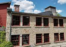
- Alton Mill (woolen mill, c.1881, now an arts centre)[19]
- Brick Work Ruins (Caledon)
- Bruce Trail (Caledon)
- Caledon Trailway (Caledon)
- Canadian Heritage Humber River (Caledon)
- Elora-Cataract Trail (Caledon)
- Grand Valley Trail (Caledon)
- Great War Flying Museum (Caledon)
- Humber Valley Trail (Caledon)
- Andrew's Treasure Trail (Caledon)
- Oak Ridges Trail (Caledon)
- Hair Pin Turn (Beside the Credit River)
- Caledon Central Public School
Organizations
- Freemasonry
- Caledon Ski Club
- Kinsmen Club Christmas Parade
- Columbian Squires
- Knights of Columbus
Protected areas

- Albion Hills Conservation Area
- Alton Forest Conservation Area
- Belfountain Conservation Area
- Caledon Lake Forest Conservation Area
- Forks of the Credit Provincial Park
- Glen Haffy Conservation Area
- Ken Whillans Conservation Area
- Palgrave Forest and Wildlife Area
- Robert Baker Forest Conservation Area
- Terra Cotta Conservation Area
- Warwick Conservation Area
Sports and recreation
Junior hockey teams include the Caledon Golden Hawks and Caledon Canadians, the latter defunct.
Minor hockey teams include the Caledon Hawks and Caledon Coyotes
Lacrosse in the Town of Caledon is represented by the Caledon Vaughan Minor Lacrosse Association which operates Minor Field and both Minor and Junior C. Box Teams
Mike Fox, the winner of the 2007 Queen's Plate, was foaled in Caledon, while Peaks and Valleys currently stands there.
Caledon Equestrian Park in Palgrave hosted the equestrian events of the 2015 Pan American Games.[20]
Caledon Centre for Recreation and Wellness, located in Bolton, Ontario.
Communities

The primary administrative and commercial centre of Caledon is the community of Bolton, which the municipal government estimated as having a population of 26,478 in 2006.[21]
Smaller communities in the town include Albion, Alloa, Alton, Belfountain, Boston Mills, Brimstone (Brimstone Point), Caledon, Caledon East, Caledon Village, Campbell's Cross, Castlederg, Cataract, Cedar Meadows, Cedar Mills, Cheltenham, Claude, Coulterville, Ferndale, Forks of the Credit, The Grange, Humber, Humber Grove, Inglewood, Kilmanagh, Lockton, Mayfield West, Macville, Melville, McLeodville, Mono Mills, Mono Road, New Glasgow, Palgrave, Queensgate, Rockside, Rosehill, Sandhill, Silver Creek, Sleswick, Sligo, Star, Stonehart, Taylorwoods, Terra Cotta, Tormore, Valleywood and Victoria. The region is otherwise very sparsely populated with farms being the only residential centres.
A number of villages or hamlets have disappeared from the current town:
- Kennedy's Corners (Old School Road and Airport Road)
- Fox's Corners (Willoughby Road and Charleston Side Road)
- Greenlaw (The Grange Sideroad and Winston Churchhill Boulevard)
- Caldwell (The Grange Sideroad and Kennedy Road)
- Caldwell Junction (Olde Baseline Road and Moutainview Road)
- Glencoe's Corners (Olde Baseline Road and Creditview Road)
- McBride's Corners (Olde Baseline Road and Hurontario Street)
Infrastructure
Emergency services
The town runs its own fire services through the composite Career and volunteer firefighters of the Town of Caledon Fire & Emergency Services, which has nine stations.
Ambulance services are run by the regional government's Peel Regional Paramedic Services, with three stations (#10, 11 and 12).
Despite being part of Peel Region, policing in Caledon is conducted from Ontario Provincial Police Caledon Detachment rather than Peel Regional Police. OPP also patrols on provincial highways within Caledon (Ontario Highway 9 and Ontario Highway 10).
Transportation
GO Transit operates two bus routes in Caledon;
- serving Bolton, Ontario from Nobleton through Vaughan connecting with the Etobicoke North GO Station on the Georgetown line.
- serving Bolton, Ontario along Peel Regional Road 50 and through east Mississauga connecting with Malton GO Station on the Georgetown line.
- serving Orangeville and Brampton connecting with Brampton GO Station on the Georgetown line via Main Street/Highway 10.
It additionally has storage and service facilities in the town.
Selected trips by Brampton Transit's Route 30 Airport Road buses extends into the Tullamore Industrial Area of the Town of Caledon, with a total of six trips per day.[22]
The town has no government-supported local public transit system. However, growing population prompted former local resident Darren Parberry to start a trial bus service with two routes, called Métis Transit, which ran briefly in 2006.[23] Caledon also ran a commercial bus operations in 1999 under the name Caledon Transit Incorporated,[24] but it ceased operations due to low ridership.
Transit services for the elderly, disabled, and infirm are provided by Caledon Community Services Transportation and Transhelp (run by Peel Region).
Taxi service is also available in the Bolton, Ontario area.
The highways in the municipality are:
- Airport Road or Peel Regional Road 7
- Hurontario Street or Highway 10
- Charleston Sideroad or Peel Regional Road 24 (formerly Highway 24)
- Queen Street or Peel Regional Road 50 (formerly Highway 50)
- Main Street and Porterfield Road, or Peel Regional Road 136 (formerly Highway 136)
- Highway 410 to Highway 10
Notable people
See also
- Media in Peel
- List of townships in Ontario
References
- "(Code 3521024) Census Profile". 2011 census. Statistics Canada. 2012. Retrieved 2012-03-01.
Notes
- Statistics Canada: 2012
- 43° 51' 44" N, 80° 8' 13" W, as per Google Earth
- 43° 49' 15" N, 79° 43' 34" W, as per Google Earth
- Hamilton, William (1978). The Macmillan Book of Canadian Place Names. Toronto: Macmillan. p. 139. ISBN 0-7715-9754-1.
- The province of Ontario gazetteer and directory. H. McEvoy Editor and Compiler, Toronto : Robertson & Cook, Publishers, 1869
- "Heritage Designation Report: Edward Ellis House" (PDF). Caledon.ca. Retrieved 7 November 2017.
- Canada, Statistics (2017). "Census Profile, 2016 Census". Statistics Canada. Retrieved 31 October 2018.
- Canada, Statistics (2017). "Census Profile, 2016 Census". Retrieved 31 October 2018.
- Government of Canada, Statistics Canada (8 May 2013). "2011 National Household Survey Profile - Census subdivision". www12.statcan.gc.ca.
- "Caledon, Ontario (City) Census Subdivision". Community Profiles, Canada 2016 Census. Statistics Canada.
- Canada, Government of Canada, Statistics. "2011 National Household Survey Profile - Census subdivision". 12.statcan.gc.ca. Retrieved 7 November 2017.
- "Council". Caledon.ca. Retrieved 7 November 2017.
- "Albion Field Centre". 1981-2010 Canadian Climate Normals. Environment Canada. Retrieved 2016-05-12.
- Heyes, Esther (1968). The Story of Albion (PDF) (2 ed.). Bolton ON: Bolton Enterprise. p. 323. Archived from the original (PDF) on 2012-05-28. Retrieved 25 June 2012.
- "Caledon Enterprise". Metroland Media. Mississauga ON. Archived from the original on 7 July 2012. Retrieved 25 June 2012.
- "Contact Info". Archived from the original on 2012-07-02. Retrieved 2012-06-25.
- https://www.historicplaces.ca/en/rep-reg/place-lieu.aspx?id=15541, Old Caledon Township Hall, Formally Recognized: 1982/01/25
- https://www.historicplaces.ca/en/rep-reg/place-lieu.aspx?id=15530&pid=0, Millcroft Inn Formally Recognized: 1991/10/07
- https://www.historicplaces.ca/en/rep-reg/place-lieu.aspx?id=2088&pid=0, Alton Mill Formally Recognized: 2004/12/07
- "OLG Caledon Pan Am Equestrian Park". toronto2015.org. Pan Am / Parapan Am Games, 2015. Retrieved January 11, 2019.
- "Archived copy" (PDF). Archived from the original (PDF) on 2011-05-27. Retrieved 2008-07-28.CS1 maint: archived copy as title (link)
- "Schedules and Maps - Route 30" (PDF). Brampton Transit. Retrieved January 11, 2019.
- "Wanted: Passengers for Bus Line". Archived from the original on 2010-02-17. Retrieved 2010-01-25.
- "Transit History of Ontario Communities (A-B)". Home.cc.umanitoba.ca. Retrieved 7 November 2017.
External links
| Wikimedia Commons has media related to Caledon, Ontario. |
| Wikivoyage has a travel guide for Caledon (Ontario). |
Places adjacent to Caledon, Ontario | |
|---|---|
Largest city: Toronto | ||
| Regions | 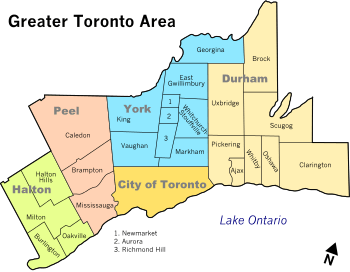 | |
| Cities | ||
| Towns | ||
| Townships and municipalities | ||