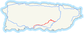
Puerto Rico Highway 14
Puerto Rico Highway 14 (PR-14) is a main highway connecting Cayey, Puerto Rico to Ponce, Puerto Rico.[2] The road runs the same course as the historic Carretera Central. The Coamo-to-Ponce section of PR-14 was built under the direction of Spanish engineer Raimundo Camprubí Escudero (b. Pamplona 15 March 1846 - d. Madrid 1924).[3]
%2C_Bo._Machuelo_Abajo%2C_Ponce%2C_Puerto_Rico%2C_visto_desde_intersecci%C3%B3n_con_la_Av._Fagot%2C_mirando_al_este_(DSC02967).jpg)
PR-14 eastbound (Ave. Tito Castro) intersection with Ave. Fagot, Ponce (PR-14, km 3.0)
| ||||
|---|---|---|---|---|
 | ||||
| Route information | ||||
| Maintained by Puerto Rico DTPW | ||||
| Length | 73.1 km[1] (45.4 mi) | |||
| Existed | 1886 (as the old Carretera Central)–present | |||
| Major junctions | ||||
| West end | ||||
| ||||
| East end | ||||
| Location | ||||
| Municipalities | Ponce, Juana Díaz, Coamo, Aibonito, Cayey | |||
| Highway system | ||||
| ||||


Route description
.svg.png)
Detailed map of PR-14 in the Municipality of Ponce
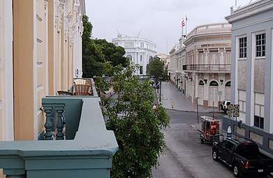
Except in the city of Ponce where (with the exception of the Ponce Historic Zone) the road is a 4-lane road known as Avenida Tito Castro, the rest of PR-14 is a two-lane country road as it makes its way through the four towns it runs through, Juana Diaz, Coamo, Aibonito and Cayey.[4] PR-14 is one of the roads that lead into the Ponce Historic Zone.[5]
Major intersections
| Municipality | Location | km[1] | mi | Destinations | Notes |
|---|---|---|---|---|---|
| Ponce | Primero–Cuarto line | 0.0 | 0.0 | Western terminus of PR-14; the Carretera Central continues toward Playa | |
| Cuarto–Tercero line | 0.5– 0.6 | 0.31– 0.37 | One-way street | ||
| Tercero | 0.7 | 0.43 | One-way street | ||
| Tercero–Quinto line | 0.8 | 0.50 | One-way street | ||
| Quinto–Sexto line | 1.2 | 0.75 | One-way street | ||
| Machuelo Abajo | 2.2 | 1.4 | |||
| 2.6 | 1.6 | Playa | |||
| Machuelo Abajo–Machuelo Arriba line | 4.6– 4.8 | 2.9– 3.0 | Mercedita Airport, San Patricio; diamond interchange | ||
| Cerrillos | 5.9 | 3.7 | |||
| Coto Laurel | 8.8 | 5.5 | |||
| Coto Laurel–Real line | 9.9 | 6.2 | |||
| Juana Díaz | Callabo | 10.9 | 6.8 | ||
| Jacaguas | 11.5 | 7.1 | |||
| 11.8 | 7.3 | ||||
| Juana Díaz barrio-pueblo–Lomas line | 13.7 | 8.5 | |||
| Juana Díaz barrio-pueblo | 14.0 | 8.7 | One-way street | ||
| 14.1 | 8.8 | One-way street; Amuelas | |||
| Tijeras | 15.6 | 9.7 | |||
| 16.6 | 10.3 | ||||
| Río Cañas Arriba–Río Cañas Abajo line | 18.5 | 11.5 | |||
| 19.5 | 12.1 | ||||
| 22.7 | 14.1 | Descalabrado | |||
| 23.7 | 14.7 | ||||
| Río Descalabrado | 23.8– 23.9 | 14.8– 14.9 | Puente Obispo Zengotita[6] | ||
| Coamo | Los Llanos | 26.2 | 16.3 | ||
| San Ildefonso | 29.7– 29.8 | 18.5– 18.5 | |||
| 29.9 | 18.6 | Puente General Méndez Vigo over the Río de la Mina[6] | |||
| 30.8– 30.9 | 19.1– 19.2 | Roundabout | |||
| Coamo barrio-pueblo | 32.8 | 20.4 | |||
| 33.1 | 20.6 | One-way street; northbound access via Calle Carrión Maduro or Calle Mario Brashi | |||
| 33.7 | 20.9 | Puente Padre Íñigo over the Río Coamo[6] | |||
| Palmarejo–Coamo barrio-pueblo line | 33.8– 33.9 | 21.0– 21.1 | |||
| Coamo barrio-pueblo | 34.2 | 21.3 | |||
| Palmarejo | 35.7 | 22.2 | |||
| Río Cuyón | 38.8 | 24.1 | Puente de las Calabazas[6] | ||
| Aibonito | Pasto–Asomante line | 45.9 | 28.5 | The Ruta Panorámica continues toward Barranquitas | |
| 46.8 | 29.1 | The Ruta Panorámica continues toward Cayey | |||
| Pasto–Llanos– Asomante tripoint | 47.3 | 29.4 | Western terminus of PR-162 concurrency | ||
| Aibonito barrio-pueblo | 49.7– 49.8 | 30.9– 30.9 | Llanos | ||
| 49.8– 49.9 | 30.9– 31.0 | ||||
| 50.2 | 31.2 | One-way street | |||
| 50.3 | 31.3 | Eastern terminus of PR-162 concurrency; one-way street | |||
| 50.5 | 31.4 | ||||
| 50.9 | 31.6 | ||||
| 51.0 | 31.7 | ||||
| Robles–Plata line | 54.9 | 34.1 | |||
| Robles–Plata line | 56.8– 56.9 | 35.3– 35.4 | Puente de Quebrada Honda over the Quebrada Honda[6] | ||
| 57.2 | 35.5 | ||||
| Río Matón | 62.9– 63.0 | 39.1– 39.1 | Puente del Río Matón[6] | ||
| Cayey | Matón Abajo | 63.0 | 39.1 | ||
| Toíta–Cayey barrio-pueblo line | 68.3 | 42.4 | |||
| Cayey barrio-pueblo | 68.7– 68.8 | 42.7– 42.8 | |||
| 69.8 | 43.4 | Southbound access via Calle José Celso Barbosa | |||
| 70.1 | 43.6 | Puente Santo Domingo over the Quebrada Santo Domingo[6] | |||
| 70.1 | 43.6 | ||||
| 71.2 | 44.2 | ||||
| 71.7 | 44.6 | Unsigned | |||
| Cayey barrio-pueblo–Monte Llano line | 73.1 | 45.4 | Eastern terminus of PR-14; the Carretera Central continues toward Cidra | ||
1.000 mi = 1.609 km; 1.000 km = 0.621 mi
| |||||
Gallery
 PR-14, PR-10, and PR-1 signs in downtown Ponce (at Calle Villa and C. Concordia, near PR-14, km 0.2)
%2C_Barrio_Machuelo_Abajo%2C_Ponce%2C_PR_(DSC04978).jpg) A former Casilla de Caminero on PR-14 (now Ave. Tito Castro) in Ponce (PR-14, near km 3.1)
A former Casilla de Caminero on PR-14 (now Ave. Tito Castro) in Ponce (PR-14, near km 3.1)%2C_Bo._Machuelo_Abajo%2C_Ponce%2C_Puerto_Rico%2C_mirando_al_oeste_(IMG_3417).jpg) Ave. Tito Castro (PR-14), Bo. Machuelo Abajo, Ponce, looking west (PR-14, near km 4.4)
Ave. Tito Castro (PR-14), Bo. Machuelo Abajo, Ponce, looking west (PR-14, near km 4.4)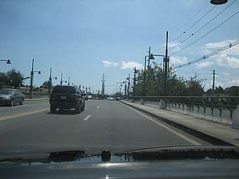 PR-14 Westbound at bridge over Río Bucaná on Avenida Tito Castro in Ponce approaching PR-10 (PR-14, near km 5.2)
See also
References
- Google (28 February 2020). "PR-14" (Map). Google Maps. Google. Retrieved 28 February 2020.
- Puerto Rico Department of Transportation and Public Works. "Datos de Transito 2000-2009" (in Spanish). Retrieved 29 March 2019.
- Ingenieros de Caminos en Puerto Rico: 1866-1898. Fernando Sáenz Ridruejo. "Anuario de Estudios Atlanticos." ISSN 0570-4065. Las Palmas de Gran Canaria (2009). No 55. p.334.
- Sur, Redaccion Voces del (26 September 2019). "Ordenan cierre de la carretera PR-14 de Aibonito a Coamo" (in Spanish).
- "Ponce. Let's Go". Archived from the original on 4 December 2010.
- Luis F. Pumarada O’Neill (1991). "Los Puentes Históricos de Puerto Rico" (PDF) (in Spanish). Retrieved 10 March 2020.
External links
![]()
- Carretera Militar/Military Road Porto Rico. Overland Monthly and Out West Magazine. Page 321. Retrieved 27 July 2013.
This article is issued from Wikipedia. The text is licensed under Creative Commons - Attribution - Sharealike. Additional terms may apply for the media files.