Coto Laurel
Coto Laurel (Barrio Coto Laurel) is one of the 31 barrios of the municipality of Ponce, Puerto Rico. Along with Anón, Marueño, Guaraguao, Quebrada Limon, Real, and San Patricio, and the coastal barrios of Canas and Capitanejo, Coto Laurel is one of the municipality's nine bordering barrios. It borders the municipality of Juana Diaz. It was founded in 1831.[1]
Barrio Coto Laurel | |
|---|---|
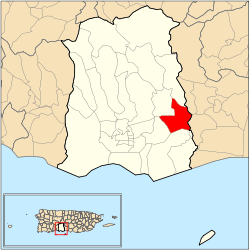 Location of barrio Coto Laurel within the municipality of Ponce shown in red | |
| Commonwealth | |
| Municipality | |
| Area | |
| • Total | 3.66 sq mi (9.5 km2) |
| • Land | 3.60 sq mi (9.3 km2) |
| • Water | 0.06 sq mi (0.2 km2) |
| Population (2000) | |
| • Total | 5,285 |
| • Density | 1,493/sq mi (576/km2) |
| Source: 2000 Census | |
Location
Coto Laurel is a suburban barrio located in the southeastern section of the municipality, east of the traditional center of the city, Plaza Las Delicias. The toponomy, or origin of the name, is a proper noun related to the word coto which in Spanish denotes tracts of land ceded to citizens in exchange for services to the king and where there were laurel trees.[2]
Boundaries
It is bounded on the north by Río Inabón and Lake Number 5, on the south by Esperanza Street, on the west by PR-10 (roughly), and on the east by Río Inabón.[3] In terms of barrio-to-barrio boundaries, Coto Laurel is bounded in the north by Cerrillos and Real, in the south by Vayas, in the west by Sabanetas and Cerrillos, and in the east by the municipality of Juana Díaz.
Features and demographics
Coto Laurel has 3.60 square miles (9.3 km2) of land area and 0.06 square miles (160,000 m2) of water area. In 2000, the population of Coto Laurel was 5,285.[4] The population density in Coto Laurel was 1,468.1 persons per square mile.[5]
The communities of Palmarejo, Llanos del Sur, and El Monte are found in Coto Laurel. Lake Giles is also in Coto Laurel. Coto Laurel is crossed by Puerto Rico's superhighway PR-52. PR-14 also serves Coto Laurel.
Landmarks
Coto Laurel is home to Vassallo Industries and San Cristobal Hospital, one of Ponce's largest hospitals. Coto Laurel's village square was built under the administration of mayor José G. Tormos Vega in 1980.
References
- Barrios de Ponce. Archived 30 September 2015 at the Wayback Machine Antepasados Esclavos.(From: Pedro Tomás de Córdoba. Memorias geográficas, históricas, económicas y estadísticas de la Isla de Puerto Rico.) Retrieved 28 November 2014.
- Government of the Municipality of Ponce. Periodico "El Señorial". Special issue: Carnaval Ponceño 2013. February 2013. Page 17. Ponce, Puerto Rico.
- General Purpose Population Data, Census 2000. Unidad de Sistemas de Información Geográfica, Área de Tecnología de Información Gubernamental, Oficina de Gerencia y Presupuesto. Gobierno de Puerto Rico. Archived August 12, 2010, at the Wayback Machine Retrieved February 17, 2010.
- Population
- City Melt Retrieved, February 18, 2010.