Public transport in the Klang Valley
Currently, there is a variety of public transport modes including buses, rail, taxis and motor-taxis[1] serving Kuala Lumpur and the surrounding Klang Valley region. However, Kuala Lumpur, with a population of 1.79 million in the city[2] and 6 million in its metropolitan area,[3] the Klang Valley, is experiencing the effects and challenges of rapid urbanisation and urban planning issues.
To resolve these issues, Kuala Lumpur City Hall (DBKL) has plans to initiate programmes that would improve the public transportation system and increase the transportation sustainability of Klang Valley. The Kuala Lumpur Structure Plan 2020, in particular, intends to respond to the unprecedented growth and changes of Kuala Lumpur’s urban transportation landscape.[4]
History of public transport in Kuala Lumpur
In the 19th century and early 20th century, most Kuala Lumpur citizens and tin miners used rickshaws, elephants, sampans, and bull- or horse-drawn carriages as basic public transportation (as in transport by means not owned by persons being transported).
From the 1960s to the 1990s, the Mini-Bus Service or Bas Mini was popular.
Local transport

Buses
There are several bus operators operating in Kuala Lumpur, linking the city centre with the suburbs of the Klang Valley. The main operator is Prasarana's subsidiaries of Rapid Bus, who took over the operations of the two main bus operators, Intrakota and Cityliner.
Other operators include Metrobus, Selangor Omnibus, Len Seng, Transnasional/Kenderaan Klang-Banting, Triton, and Permata Kiara.
Rail
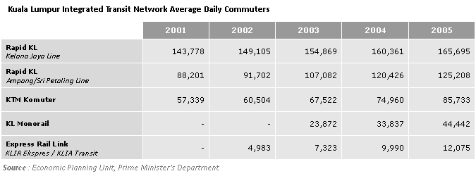
The Klang Valley Integrated Transit System currently consists of three light rapid transit (LRT) lines, two commuter rail lines, one monorail line, one bus rapid transit line, one mass rapid transit (MRT) line and three airport rail links, two to the Kuala Lumpur International Airport and one to the Sultan Abdul Aziz Shah Airport. The LRT lines connect the city centre with major suburbs like Petaling Jaya, Subang Jaya, Gombak, Puchong and Bukit Jalil around the city centre. The MRT and commuter rail lines link the city centre with other major towns and cities outside the city such as Shah Alam, Petaling Jaya, Klang, Rawang, Kepong, Kajang, Sungai Buloh and others. The monorail serves various locations in the city centre. There are several interchange stations that integrate these rail services. Several railway stations are also served by the intercity KTM ETS service, which connect the Klang Valley with other states and regions in Peninsular Malaysia.
|
Taxis
Metered taxis can be hailed throughout the city. However, traffic jams are fairly common in KL, especially during rush hour, and it might be difficult to get a taxi at that time. There have been many instances of taxi drivers charging extravagant fares, especially for tourists, who are therefore advised to travel in taxis which charge fares according to a meter, and insist that the meter is used.
_1.6_sedan%2C_Teksi_(2014-01-03).jpg)
Motor-Taxis
Fixed rate and metered motorcycle-taxi or "motor-taxi[5]" can now be found in and utilized by KL citizens as well as tourists since its introduction on Nov 16, 2016.[5]
Transit hubs
Intercity travel
For intercity travel, the main transit hubs in Kuala Lumpur are:
- Pudu Sentral — an intercity bus terminal located in the city centre. A new bus terminal, Plaza Rakyat is planned to replace neighbouring Pudu Sentral. However, the construction has been halted indefinitely. There is an LRT and MRT station nearby that connects to the building.
- KL Sentral — Kuala Lumpur's main railway station.
- Duta Bus Terminal — for buses operated by Transnasional and Airport Coach (bus services to KLIA)
- Terminal Bersepadu Selatan - The newest transport hub in the Klang Valley. It replaced Pudu Sentral as the major hub for all intercity buses in the Klang Valley. Connecting with KTM Seremban Line, KTM ETS, KLIA Transit & LRT Sri Petaling Line.
Local rail transport
- KL Sentral — a modern multi-modal transport hub served by KTM Komuter, KTM ETS, LRT, MRT, ERL, monorail as well as local buses, airport buses to the KLIA, and several intercity buses
- Masjid Jamek — an LRT interchange between the LRT Kelana Jaya Line, LRT Ampang Line & LRT Sri Petaling Lines.
- Bandar Tasik Selatan station — a train interchange between the LRT Sri Petaling Line, KTM Seremban Line, KTM ETS and ERL KLIA Transit.
Local bus terminals
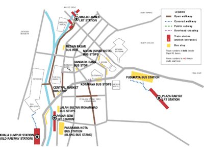
KL Sentral, Titiwangsa, KLCC, Maluri, and Medan Pasar form Rapid KL's bus interchanges in the city. Meanwhile, private bus operators are mostly based at the Jalan Tun Tan Cheng Lock (formerly known as Jalan Cheng Lock) area which includes Pasaramakota, Central Market, Bangkok Bank, Medan Pasar, Kotaraya, Sinar Kota and Puduraya.
There are also several suburban bus hubs that serve as terminals and interchanges.
Legacy terminals
Traditionally, most bus services, whether local or intercity originated from the city centre, especially in the areas around Jalan Tun Tan Cheng Lock. Recently transport operators have decided to unilaterally move operations elsewhere. For example, executive bus operators, especially those headed for Singapore, have switched to less congested locations like the Kuala Lumpur Railway Station, KL Sentral, Bangsar and Petaling Jaya. Rapid KL itself has shifted operations to its city hubs. The government meanwhile has been encouraging buses to use other newer terminals like Pasarakyat and Duta Bus Terminal.
The Kuala Lumpur Railway Station ceased to serve intercity trains in 2001 when operations shifted to neighbouring KL Sentral. However, many other operations such as KTM Komuter services and postal services by Pos Malaysia are still maintained there.
Regulation
The public transport system is regulated by various authorities, including the Commercial Vehicle Licensing Board (CVLB) of the Ministry of Entrepreneur and Co-operative Development, the Ministry of Transport and local governments such as the Dewan Bandaraya Kuala Lumpur and the other city and municipal councils.
There is no single body that regulates the whole sector.
The Integration and Restructuring of the Public Transport System in the Klang Valley (Inspak) steering committee, established in July 2003, is tasked with encouraging greater use of public transportation to reduce traffic congestion and initiate the establishment of the Klang Valley Urban Transport Authority as the regulatory authority for public transportation in the Klang Valley. Little has been said about the establishment of this authority ever since.
Rapid KL was established in 2004 by the Ministry of Finance to provide an integrated public transport system in the Klang Valley incorporating rail and bus services as part of Inspak. It holds quasi-regulatory powers in the sense that unlike other bus operators, it has much greater freedom to set its own routes. Furthermore, its fare structure differs from that set by the CVLB.
By 2007, passengers have access to Touch 'n Go ticketing system on RapidKL systems, KL Monorail, and KTM Komuter.[6]
Recent efforts
Recent efforts on urban transportation design addresses both the functional and aesthetic aspects of the city’s built environment. The Kuala Lumpur Structure Plan 2020 particularly cites good transportation linkage as essential factors to the success of the city, noting that public transportation would enable greater flexibility and movement. For the residents of Kuala Lumpur, it is important to provide transportation structure that allows members of the community equal accessibility. The KLCH recognizes “low public transport modal share”[7] as the key problem to high demands on road infrastructure and traffic congestion.
In an effort to increase public transportation usage, KLCH is currently expanding and constructing the Mass Rapid Transit lines that would provide more coverage to areas within the conurbation. Additional attention to the design of the newest public transport facilities is made to accommodate individuals with special needs. Also, to avoid traffic congestion occurring on local streets, major bus and rail interchange stops will be strategically located at points of intersections of major roads.[4] Recent studies also show that people of Klang Valley are willing to use public transport system if it is efficient and comfortable [8] However, this shift is highly impacted by peers pressure (subjective norm)[9].
On 18th June 2020, RapidKL's subsidiary Rapid Bus released new features on real time locations of bus in Google Maps, via collaboration with Google Transit[10][11][12][13]. Almost 170 RapidKL's bus routes are covered with this real time feature. Rapid Bus also plans to expand the application to MRT feeder bus service, Rapid Penang, and Rapid Kuantan in the future.
References
- "Teksi motosikal murah, pantas". HM Online. 2016-12-04. Retrieved 2016-12-22.
- "Department of Statistics Malaysia Official Portal". www.statistics.gov.my. Archived from the original on 2016-06-23. Retrieved 2016-11-14.
- "KL on track to megacity status". focusmalaysia.my. Archived from the original on 2014-12-19. Retrieved 2016-11-14.
- Emizul. "KLCH Strategic Plan". www.dbkl.gov.my. Retrieved 2016-11-14.
- "Teksi motosikal 'Dego Ride' bantu elak sesak". BH Online. 2016-11-23. Retrieved 2016-12-22.
- Rapid KL Launches Integrated Smart Card Ticketing System
- "Kuala Lumpur Structure Plan 2020 : Transportation". www.dbkl.gov.my. Retrieved 2016-11-14.
- Kaffashi, Sara (2016-11-01). "Are Malaysians eager to use their cars less? Forecasting mode choice behaviors under new policies". Land Use Policy. 56: 274–290. doi:10.1016/j.landusepol.2016.05.005.
- Kaffashi, Sara (2019-10-20). "Transforming to a low carbon society; an extended theory of planned behaviour of Malaysian citizens". Journal of Cleaner Production. 235: 1255–1264. doi:10.1016/j.jclepro.2019.07.047.
- "Aplikasi Google Maps Untuk Bantu Rancang Perjalanan Dengan Bas". Retrieved 2020-06-21.
- "Google Maps app to help Rapid bus users plan trips". Retrieved 2020-06-21.
- "Rapid Bus collaborates with Google Maps app to help users plan trips, view real-time location of buses". Retrieved 2020-06-21.
- "https://themalaysianreserve.com/2020/06/19/rapidkl-users-can-now-plan-bus-trips-via-google-maps/". Retrieved 2020-06-21. External link in
|title=(help)
External links
- Kuala Lumpur Mass Rapid Transit Website (KL MRT Website)
- iMetro - Interactive transport guide of Kuala Lumpur transport system
| Bus service |
| ||||||||||||||||||||||
|---|---|---|---|---|---|---|---|---|---|---|---|---|---|---|---|---|---|---|---|---|---|---|---|
| Major Bus Hub |
| ||||||||||||||||||||||
| Companies |
| ||||||||||||||||||||||
| Related topics |
| ||||||||||||||||||||||
| Automated fare collection |
| ||||||||||||||||||||||
| Commissions |
| ||||||||||||||||||||||
| Buses |
| ||||||||||||||||||||||
italics indicated the project is under construction. | |||||||||||||||||||||||
| Overview |
| ||||||||||||||||||||||||||||||||||||||||||||||||||||||||||||||||||||||||
|---|---|---|---|---|---|---|---|---|---|---|---|---|---|---|---|---|---|---|---|---|---|---|---|---|---|---|---|---|---|---|---|---|---|---|---|---|---|---|---|---|---|---|---|---|---|---|---|---|---|---|---|---|---|---|---|---|---|---|---|---|---|---|---|---|---|---|---|---|---|---|---|---|---|
| Lines |
| ||||||||||||||||||||||||||||||||||||||||||||||||||||||||||||||||||||||||
| Operator(s) |
| ||||||||||||||||||||||||||||||||||||||||||||||||||||||||||||||||||||||||
| Rolling Stock(s) & Manufacturer(s) |
| ||||||||||||||||||||||||||||||||||||||||||||||||||||||||||||||||||||||||
| Depots |
| ||||||||||||||||||||||||||||||||||||||||||||||||||||||||||||||||||||||||
| Indonesia |
| ||||||||||||||||
|---|---|---|---|---|---|---|---|---|---|---|---|---|---|---|---|---|---|
| Malaysia | |||||||||||||||||
| Myanmar | |||||||||||||||||
| Philippines |
| ||||||||||||||||
| Singapore | |||||||||||||||||
| Thailand |
| ||||||||||||||||
| Vietnam |
| ||||||||||||||||
Note: Under construction & planned lines are in Italics | |||||||||||||||||