Transport in Kuala Lumpur
Transportation in Kuala Lumpur, the capital city of Malaysia, consists of highly developed intermodal infrastructure. This includes an extensive road network, an integrated railway network, airports and other modes of public transport. Kuala Lumpur is part of the Klang Valley, an urban conglomeration consisting of the city as well as surrounding towns and cities in the state of Selangor. The Klang Valley has the country's largest airport, the Kuala Lumpur International Airport, as well as the country's largest intermodal transport hub and railway station, Kuala Lumpur Sentral.

History
The first airport in Kuala Lumpur, Simpang Airport, commenced operations in 1952, and was the main airport for Malaysia until 1965. In 1965, the Subang International Airport became the main international airport in Kuala Lumpur and Malaysia until 1998, before being taken over by the new constructed Kuala Lumpur International Airport (KLIA) in Sepang. The Simpang Airport was taken over by and converted into an air-base for the Royal Malaysian Air Force, while the Subang Airport (renamed Sultan Abdul Aziz Shah Airport) was repurposed as a general aviation and low-cost carrier airport.
The Kuala Lumpur Mini Bus service is one of the oldest bus services in Malaysia and commenced operation in 1975.[1]Taxis have been a common sight in Kuala Lumpur ever since the 1950s, and in the 1970s and 1980s the Morris Oxford was a common model used as a taxi.
Cycling
Public transport
Rail Infrastructure
Kuala Lumpur's integrated railway system consists of several lines owned and operated by 4 major companies. Among the operators, Rapid Rail, a component of Prasarana Malaysia, and Keretapi Tanah Melayu are the largest rail operators in Kuala Lumpur.Keretapi Tanah Melayu alone carried 30,934,651 passengers in the year 2005.[2] The railway system in Kuala Lumpur is categorised into different types: light rapid transit (LRT), mass rapid transit (MRT), commuter rail, airport rail links and a monorail. The LRT, MRT and monorail form Kuala Lumpur's metro system.
Light rapid transit (LRT)
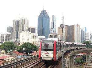
There are three fully grade-separated light rapid transit (LRT) systems in Kuala Lumpur, the Kelana Jaya Line, Sri Petaling Line and Ampang Line, The lines function as light metro services are all operated by Rapid Rail.
The Kelana Jaya Line links the city centre with the major towns and cities of Subang Jaya, Petaling Jaya and Gombak. To date, it carries over 170,000 passengers a day. At 46.4 km in length, the Kelana Jaya Line is the second-longest fully automated driverless metro system in Malaysia.
The Sri Petaling Line extends from the city centre towards the south of Kuala Lumpur and through Puchong, before meeting the Kelana Jaya Line at their common terminus station, Putra Heights. The Ampang Line serves the eastern part of Kuala Lumpur as well as Ampang. Both lines share a common section between Sentul Timur and Chan Sow Lin, before divering towards the respective terminus, and have a combined length of 45.1 km. These two lines carry over 130,000 to 150,000 per day on a weekday basis and an average of 120,000[3] per day on weekends.
A fourth LRT line is currently under construction which will connect Bandar Utama with Klang through the city of Shah Alam. Despite not being within the borders of Kuala Lumpur, the Bandar Utama-Klang Line will be connected to the Klang Valley Integrated Transit System through interchange stations with the Kelana Jaya Line, Kajang Line and Port Klang Line, allow commuters from the city to travel as far as Shah Alam and Klang on the western side of Selangor.
All LRT lines run on standard-gauge tracks.
Mass rapid transit (MRT)
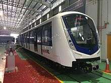
Kuala Lumpur currently has one mass rapid transit (MRT) line, the Kajang Line. The Kajang Line provides high-capacity metro services between the city and the outer parts of the Klang Valley. The lines runs from Sungai Buloh to Kajang, running through the city centre. The line is 51 km long and is currently the longest full-automated driverless metro system in Malaysia. The line is owned by MRT Corp but is also operated by Rapid Rail, and functions as part of the Rapid KL system.
A second MRT line, the Putrajaya Line, is currently under construction which, once complete, will run from Sungai Buloh to Putrajaya, pass through the city centre. It will provide rail transport to southern Kuala Lumpur and Seri Kembangan before terminating at Putrajaya. It will also be the second rail link from Kuala Lumpur with Putrajaya, the country's administrative capital, after the KLIA Transit line.
Commuter rail
Commuter rail in Kuala Lumpur is mainly operated by Keretapi Tanah Melayu (KTM). It operated three lines in Kuala Lumpur, namely the Port Klang Line, Seremban Line and Skypark Link. All three lines integrate at KL Sentral, the largest railway station and intermodal transport hub in Malaysia, which is also served by other rapid transit lines. The commuter lines provide long distance rail transport to the outer fringes of the Klang Valley, as well Batu Caves, Shah Alam, Petaling Jaya and Klang in Selangor. The Seremban Line travels south as far as Pulau Sebang in Malacca, while the Port Klang Line extends all the way to Tanjung Malim in Perak. The Skypark Link functions as an airport rail link from the city centre to the Sultan Abdul Aziz Shah Airport (Subang Airport) in Subang.
The KTM Komuter system is the only rail system in Kuala Lumpur which runs on metre-gauge tracks. The KTM Komuter shares the same tracks with the KTM ETS, providing interchanges with the inter-city rail service.
Airport rail links
Express airport rail link is provided by both the Skypark Link to the Subang Airport, as well as the KLIA Ekspres line operated by Express Rail Link (ERL) to the Kuala Lumpur International Airport (KLIA). The KLIA Ekspress provides non-stop service between KL Sentral and KLIA, without stopping in any of the stations in between. The journey only takes 28 minutes with a maximum speed of 160 km/h. 15-minute intervals during peak hours and 20-minute intervals during off-peak hours.
The KLIA Transit line shares the same tracks as the KLIA Ekspres. Also operated by ERL, KLIA Transit stops at all stations between KL Sentral and KLIA, providing commuter rail service apart from a rail link from the city centre to the airport. KLIA Transit is currently the only rail link between Kuala Lumpur and Putrajaya.
The Skypark Link, KLIA Transit and KLIA Ekspres share a common terminus at KL Sentral station, allowing passengers to transfer between the airports using the rail lines.
While the KTM Komuter system uses metre-gauge tracks, the ERL system uses standard-gauge tracks.
Monorail

Previously operated by KL Infrastructure Group, the monorail service in Kuala Lumpur serves as a people mover system for the city. It connects KL Sentral transport hub with the Golden Triangle area of Kuala Lumpur. The system spans over 8.6 km, with 11 elevated stations, and has 36,000 daily passengers. Since November 2007, the monorail service has been taken over by Prasarana Malaysia and merged into the Rapid KL network.[4]
Buses
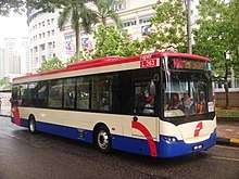
Kuala Lumpur's bus service was rather poor compared to other cities around the world before the bus network revamp, resulting in only 16% of the total population in Klang Valley using public transport.[5]
On 1 December 2015, the Land Public Transport Agency (formerly SPAD) under the Ministry of Transport revamped the bus network. Through this exercise, all bus routes were reorganised into 8 smaller corridors based on the main trunk roads connecting Kuala Lumpur's city center. In total, 8 stage bus corridors were introduced, namely the Ampang Corridor, Cheras Corridor, Sungai Besi Corridor, Klang Lama Corridor, Lebuhraya Persekutuan Corridor, Damansara Corridor, Jalan Ipoh Corridor, and Jalan Pahang Corridor were revamped under the Kuala Lumpur/ Klang Valley region.[6]
Rapid Bus is the largest single operator of the bus network in Malaysia. Bus fare varies with bus operator, where Rapid Bus uses a cashless system and Metrobus Nationwide, SJ Bus and Selangor Omnibus uses cash system. Within the city centre, Rapid Bus also operates seven free GoKL City Bus lines.
On 18 June 2020, Rapid Bus released new features on real time locations of bus in Google Maps, via collaboration with Google Transit[7][8][9][10]. Almost 170 RapidKL's bus routes are covered with this real time feature. Rapid Bus also plans to expand the application to MRT feeder bus service, Rapid Penang, and Rapid Kuantan in the future.
Intercity transport
Inter-city rail
The main Inter-city rail service in Malaysia is provided by Keretapi Tanah Melayu (KTM), which operates the KTM ETS service. KTM ETS operates along the KTM West Coast railway line, between Padang Besar in Perlis and Gemas in Negeri Sembilan. Almost all KTM ETS services orginate or run through the Kuala Lumpur Sentral station (KL Sentral) and connects the city centre with all the states along the West Coast of Peninsular Malaysia.
At Padang Besar, the West Coast line connects with the Thai railway network operated by the State Railway of Thailand. At Gemas, the railway line is connected with the KTM East Coast railway line. The West Coast line terminates at the Woodlands Train Checkpoint in Singapore. The East Coast line, as well as the remaining southern portion of the West Coast line is served by KTM Intercity, another inter-city rail service also operated by KTM, providing rail transport to the East Coast states and Johor, and crossing the international border into Singapore. KTM Intercity and KTM ETS interchange at Gemas station.
The railway lines are built on the metre gauge. The line between Padang Besar and Gemas is double-tracked and electrified, while the southern part of the West Coast line as well as the entire East Coast line is single-tracked and not electrified, allowing on diesel hauled trains to run on them.
Double tracking and electrification works of the sourthern portion of the West Coast line between Gemas and Johor Bahru are currently underway. Once completed, the KTM ETS system will be expanded to the south, connecting Kuala Lumpur with their entire West Coast rail line.
Kuala Lumpur–Singapore High Speed Rail
Plans are underway to construct Asia's first transnational high-speed rail system (HSR) between Kuala Lumpur and Singapore. It is envisaged to link Penang, Kuala Lumpur with Singapore.
Roads

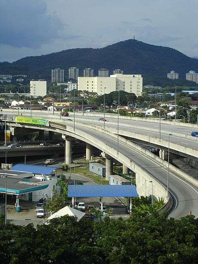
Roads are the major arteries of Kuala Lumpur's transport network. The road network system in Kuala Lumpur is similar to the city road network system in major Chinese cites, where it has ring roads. The main ring roads in Kuala Lumpur are Kuala Lumpur Inner Ring Road, Kuala Lumpur Middle Ring Road 1 and Kuala Lumpur Middle Ring Road 2. Roads in Kuala Lumpur are usually 3 lanes in each direction, and certain roads such as Jalan Sultan Ismail and Jalan Bukit Bintang are one-way streets.[11]
- Expressways
Expressways in Kuala Lumpur are tolled roads. They serve as an alternative during peak periods at which time some parts of Kuala Lumpur's ring roads become highly congested. Kuala Lumpur is well connected by many intracity expressways such as the Ampang–Kuala Lumpur Elevated Highway. Moreover, Kuala Lumpur is the home for the world's first[12] SMART Tunnel, which is a unique solution to Kuala Lumpur's long-term traffic problems and floodwater mitigation woes.
Most expressways in Kuala Lumpur adopt an open toll collection system. NKVE is the only closed toll system in Klang Valley. In the open toll system, the user pays the toll at each toll plaza, while for the closed toll system, the tolls are to be paid at the toll plazas when exiting the expressway. Payment options includes cash, stored value card Touch 'n Go or the electronic toll collection system SmartTAG.
Access from the city to the surrounding areas are facilitated by a series of expressways which is both integrated and complex. From the city centre to the south-western areas, access is provided mainly from Federal Highway which connects the city to Klang and bridging Petaling Jaya, Subang Jaya, Kelana Jaya and Shah Alam. New Pantai Expressway provides an alternative route to Subang Jaya, bypassing the morning and evening traffic congestion on the Federal Highway. An alternative connection to Shah Alam, Subang Jaya and Klang is provided by New Klang Valley Expressway which connects with the Sprint Expressway. This connects the city centre to Damansara, to the west. The New Klang Valley Expressway also provides connections to Sungai Buloh and Kepong and is linked to the northern section of the North–South Expressway, which provides access to northern states like Perak, Penang and Kedah. Connection from Damansara in the northwest to Puchong in the south-west of Kuala Lumpur is facilitated by Damansara–Puchong Expressway, which also provides connection to Putrajaya.
Access from the city centre to southern areas is provided by Sungai Besi Expressway, which leads to the Bukit Jalil and Sungai Besi areas. The highway runs in parallel with the Kuala Lumpur–Seremban Expressway. The highway also provides an alternative route to Kajang by connecting with Kajang Dispersal Link Expressway.
Access from the city centre to south-eastern areas is provided by Cheras Highway which connects to Cheras. The highway is connected with Cheras–Kajang Expressway, which provides access to Kajang and that highway itself is connected with Kajang–Seremban Highway and Kajang Dispersal Link Expressway, giving alternative access to Seremban and southern parts of the city.
Connection from the city centre to eastern areas is provided by Ampang–Kuala Lumpur Elevated Highway. The highway is connected to Kuala Lumpur Middle Ring Road 2 for access to Batu Caves and Gombak. In close proximity with Karak Expressway, it provides access to the east coast area of Malaysia. There is no dedicated highway leading from the city centre to the northern areas such as Batu Caves However, Jalan Kuching is the main road from the city to the northern area.
The MMR2 connects with KESAS Highway which provides yet another alternative route to Shah Alam and Subang Jaya. The KESAS highway also has connections to Kuala Lumpur–Seremban Expressway which integrates with the southern section of North–South Expressway and North–South Expressway Central Link which provide access to Kuala Lumpur International Airport.
Connection from the city to Putrajaya is facilitated by a direct highway, Kuala Lumpur–Putrajaya Expressway which also provide connections to Kuala Lumpur International Airport through North–South Expressway Central Link. The highway also provides alternative access to southern areas of the city such as Puchong and Bukit Jalil.
Below is a non-exhaustive list of expressway serving the Klang Valley area:
Taxis
_1.6_sedan%2C_Teksi_(2014-01-03).jpg)
Metered taxis or 'Teksi Bermeter' in Malay can be hailed throughout the city. However, traffic jams, especially during rush hour are fairly common in KL and it might be difficult to get a taxi during rush hour. There have been many incidents of taxi drivers charging extravagant fares, especially among tourists, therefore, tourists are advised to travel with taxis who charge fare according to meters, or insist on using the meter.
Taxi stands are available around the city and most taxis will stop at the taxi stand. Taxis in Kuala Lumpur are coloured in various colours such as a combination of red-white, red, yellow-blue, green or yellow. However, taxis could be easily recognised as the taxis' vehicle registration number carries a prefix H and LIMO for airport limousine.
Intermodal transport hub
There are various intermodal transport hubs in Kuala Lumpur, with one major intermodal transport hub in the city centre of Kuala Lumpur, the Kuala Lumpur Sentral transport hub.
- Kuala Lumpur Sentral

Kuala Lumpur Sentral (KL Sentral) or Sentral Kuala Lumpur is a transit-oriented development that houses the main railway station of Kuala Lumpur, which has officially taken over the role of Kuala Lumpur Railway Station. It is the largest railway station in Southeast Asia.
Stesen Sentral is designated the transport hub within its KL Sentral development project, although both the public and connected transit lines generally refer to the station itself as "KL Sentral". Among rail lines in Kuala Lumpur, Kelana Jaya Line, KL Monorail, KTM Komuter, KTM Intercity, KLIA Ekspres and KLIA Transit integrate in this railway station.
Located within Stesen Sentral, the KL City Air Terminal (KL CAT) is virtually an extension of the Kuala Lumpur International Airport. KL CAT also has luggage check-in services. Currently, only passengers flying Malaysia Airlines, Cathay Pacific, Emirates and Royal Brunei Airlines can check in their luggage at KL CAT. KL Sentral has also been made a city bus hub by RapidKL under its bus network revamp. It is the bus hub for city shuttle bus (BANDAR) and trunk routes(UTAMA). Furthermore, some buses departing to Kuala Lumpur International Airport's Low Cost Carrier Terminal also originate from KL Sentral.
Stesen Sentral will be able to accommodate 50 million passengers a year and up to 100 million by 2020.
- Puduraya
Puduraya is the main bus terminus for Kuala Lumpur. Long-distance buses arrive and leave from Puduraya for all over Malaysia. Under Kuala Lumpur 2020 Structural Plan, there are plans to move some bus operators to inter-regional hubs in other parts of Kuala Lumpur such as Perhentian Duta, Gombak Hub and Bandar Tasik Selatan hub to avoid massive congestion in Puduraya.[13]
Puduraya is accessible via Ampang Line, at Plaza Rakyat Station
Port Infrastructure
Airports

Kuala Lumpur is the main gateway for Malaysia as it has the country biggest airport, Kuala Lumpur International Airport, about 25 million passengers used the airport, making it the busiest airport in Malaysia.[14]
The city is served by 2 airports, which is Kuala Lumpur International Airport and Sultan Abdul Aziz Shah Airport(formerly. Subang International Airport). Both airports have international connections, but Sultan Abdul Aziz Shah Airport is solely for turboprop aircraft and private jets only.[15] Kuala Lumpur International Airport apart from being the main passenger gateway, it is also the main cargo destination in Malaysia by cargo traffic.[14] Kuala Lumpur International Airport is linked to the city centre by KLIA Express by railway, major expressways and bus service. Whereas Subang Airport is well connected by road networks and bus service.
Kuala Lumpur International Airport (KLIA) is capable of handling 35 million passengers and 1.2 million tonnes of cargo a year in its current phase. It is currently ranked as the 13th busiest airport in the world by international passenger traffic where it has handled 24,129,748 passengers in the year of 2006. In the same year, it is also ranked 30th busiest airport in the world by cargo traffic where it has handled 677 446 metric tonnes of cargo.[16] Kuala Lumpur International Airport is one of the only few airports in East Asia to have links to South America, where Malaysia Airlines, has flights out of Kuala Lumpur International Airport to Buenos Aires via Johannesburg and Cape Town.
Both airports are operated by Malaysia Airports and is the hub for Malaysia Airlines, Malaysia Airlines Cargo, AirAsia and AirAsia X in Kuala Lumpur International Airport and Firefly, Transmile Air Services and Berjaya Air in Subang Airport. Moreover, KLIA is also the stopover point for the kangaroo route for Malaysia Airlines.
Ports
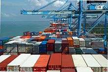

Port Klang is one of the main sea ports of Malaysia, located in the district of Klang in the state of Selangor. It serves the Klang Valley, including the federal capital Kuala Lumpur and federal administrative capital Putrajaya.
Port Klang was originally known as Port Swettenham when it was founded under British colonial rule in 1893, after the then British Resident High Commissioner for the Malay State, Sir Frank Swettenham. Official opening of the port was on 15 September 1901, which developed as a new port after a study found that its coastal area had a harbour with deep anchorage, free from dangers and very suitable for wharves. Its development was accelerated further with the extension of a railway line from Kuala Lumpur to the new port. The Port Klang Authority, established 1 July 1963, administers the three ports in the Port Klang area: Northport, Southpoint and West Port. As of November 2007, West Port, part of the three ports in Port Klang, has handled 4 million twenty-foot equivalent units (TEU) worth of containerised cargo, and is moving towards its 4.3 millionth TEU by end of 2007. Together with North port and South port, Port Klang handled 7.12 million TEU of containerised cargo and 133.5 million tonnes of conventional cargo in 2007.[17]
Apart from cargo ships, Port Klang also features a cruise ship terminal in Westport where SuperStar Virgo and Queen Mary 2,[18] the world's second largest passenger ship has docked in the terminal for excursion. Port Klang is also the home port of call for SuperStar Gemini.
Port Klang has its own free zone, called Port Klang Free Zone (PKFZ). It is an integrated 1,000-acre (4.0 km2) international cargo distribution and consolidation centre situated in Port Klang, the world's 13th-ranked port in 2005 in terms of throughput volume.[19] The PKFZ is designed to promote entreport trade and manufacturing industries involved in producing goods primarily for export. In 2007, PKFZ Authority has secured US$220 million and projected to secure another US$184 million[20] in 2008. The project is similar to Dubai's Jebel Ali Free Zone, which previously PKFZ is managed by Jebel Ali Free Zone Authority (JAFZA).
Port Klang is well connected by road and railway networks. On rail, Port Klang is connected by Keretapi Tanah Melayu, whereas by road, Port Klang is connected by Federal Highway and Shah Alam Expressway
Future Projects
Plaza Rakyat
Plaza Rakyat is a mixed used skyscraper complex initiated during the 1990s that was to be completed but was halted due to the 1997 Asian financial crisis. The building was intended to replace Puduraya bus depot and also to provide better connectivity to Ampang Line's Plaza Rakyat LRT station. As of May 2013, the site remains abandoned.
Multi Lane Free Flow
By 2008, expressways in Kuala Lumpur will introduce Multi Lane Free Flow system similar to SmartTAG. Under the Multi Lane Free Flow, which is similar to system used extensively in Europe, the United States, Australia, Canada and Singapore, the toll changes will be deducted electronically as vehicles beating special tags pass through t plazas a normal driving speeds as fast as 180 km/h, as there will be no barriers.[21] Trails of the system is expected to be run starting November 2008 with the Sungai Pencala Toll Plaza on the Damansara–Puchong Expressway(LDP) as the test site.[22] Shah Alam toll plaza as also been selected as a new test site for the system beginning December 2008.[23]|This system will implement in 2010 by stages
Outer ring railway service
Currently in proposal phase as of April 2008, KTM propose a railway link to connect all suburbs in the Klang Valley. The 70 km line will be a circular loop and expected to link Sentul, Kepong, Sungai Buloh, Kelana Jaya, Shah Alam, Cheras and Bandar Tasik Selatan without going through the city centre.[24]
Bandar Tasik Selatan integrated transport hub
The Bandar Tasik Selatan station will be upgraded to an integrated transport hub. It is expected to serve buses coming from the south of Kuala Lumpur. Construction has started since November 2007 and expected to complete by 2010.[25] Currently, the station serves Ampang Line, Rawang-Seremban Route of the KTM Komuter and KLIA Ekspres line.
See also
- Public transport in Kuala Lumpur
- Kuala Lumpur–Singapore High Speed Rail
References
- Kuala Lumpur Mini-Bus Service
- KTMB Statistics on ridership
- Amapng Line Ridership
- Prasarana new operator of KL Monorail Archived 2007-12-01 at the Wayback Machine
- "Prasarana to buy trains worth RM1.2bil". The Star. 2006-10-13. Archived from the original on 2007-09-30. Retrieved 2006-10-22.
- "The Bus Network Revamp (BNR) | Agensi Pengangkutan Awam Darat (APAD)". www.apad.gov.my. Retrieved 2020-04-05.
- "Aplikasi Google Maps Untuk Bantu Rancang Perjalanan Dengan Bas". Retrieved 2020-06-21.
- "Google Maps app to help Rapid bus users plan trips". Retrieved 2020-06-21.
- "Rapid Bus collaborates with Google Maps app to help users plan trips, view real-time location of buses". Retrieved 2020-06-21.
- "https://themalaysianreserve.com/2020/06/19/rapidkl-users-can-now-plan-bus-trips-via-google-maps/". Retrieved 2020-06-21. External link in
|title=(help) - One Way Streets in Golden Triangle
- World First Dual Purpose Road Tunnel opens Archived 2006-05-22 at the Wayback Machine
- KL 202 Structural Plan
- Malaysia Airports 2006 Air Statistics
- Subang Airport for Turboprops only Archived 2007-12-18 at the Wayback Machine
- Airport Traffic
- Port Klang expects to handle 7.74m TEU this year
- QM2 Sails into Port Klang
- Port Klang Free Zone
- Two more new investors for PKFZ
- "Works Department of Malaysia to introduce Multi Lane Free Flow in Kuala Lumpur". Ministry of Works Malaysia. Retrieved 2007-03-08.
- "'No stop' toll trials to begin in November". The Star. 2008-07-22. Retrieved 2008-07-22.
- "Booth-free trial run at Batu Tiga". New Straits Times.
- "Commuter line for suburbs". The Star. Archived from the original on 2008-04-21. Retrieved 2008-04-17.
- "RM570mil terminal project to proceed". The Star. 2008-07-08. Retrieved 2008-07-08.
| Bus service |
| ||||||||||||||||||||||
|---|---|---|---|---|---|---|---|---|---|---|---|---|---|---|---|---|---|---|---|---|---|---|---|
| Major Bus Hub |
| ||||||||||||||||||||||
| Companies |
| ||||||||||||||||||||||
| Related topics |
| ||||||||||||||||||||||
| Automated fare collection |
| ||||||||||||||||||||||
| Commissions |
| ||||||||||||||||||||||
| Buses |
| ||||||||||||||||||||||
italics indicated the project is under construction. | |||||||||||||||||||||||
| Overview |
| ||||||||||||||||||||||||||||||||||||||||||||||||||||||||||||||||||||||||
|---|---|---|---|---|---|---|---|---|---|---|---|---|---|---|---|---|---|---|---|---|---|---|---|---|---|---|---|---|---|---|---|---|---|---|---|---|---|---|---|---|---|---|---|---|---|---|---|---|---|---|---|---|---|---|---|---|---|---|---|---|---|---|---|---|---|---|---|---|---|---|---|---|---|
| Lines |
| ||||||||||||||||||||||||||||||||||||||||||||||||||||||||||||||||||||||||
| Operator(s) |
| ||||||||||||||||||||||||||||||||||||||||||||||||||||||||||||||||||||||||
| Rolling Stock(s) & Manufacturer(s) |
| ||||||||||||||||||||||||||||||||||||||||||||||||||||||||||||||||||||||||
| Depots |
| ||||||||||||||||||||||||||||||||||||||||||||||||||||||||||||||||||||||||