Prehistoric pile dwellings around the Alps
Prehistoric pile dwellings around the Alps are a series of prehistoric pile dwelling (or stilt house) settlements in and around the Alps built from about 5000 to 500 B.C. on the edges of lakes, rivers or wetlands. In 2011, 111 sites located variously in Switzerland (56), Italy (19), Germany (18), France (11), Austria (5), and Slovenia (2) were added to the UNESCO World Heritage Site list.[1] In Slovenia, these were the first World Heritage sites to be listed for their cultural value.[2]
| UNESCO World Heritage Site | |
|---|---|
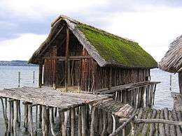 Reconstruction of a pile house at the Pfahlbau Museum Unteruhldingen on Lake Constance in Germany | |
| Location | (see map) |
| Includes | 111 locations in Austria, France, Germany, Italy, Slovenia and Switzerland |
| Criteria | Cultural: (iv), (v) |
| Reference | 1363 |
| Inscription | 2011 (35th session) |
| Area | 274.2 ha (678 acres) |
| Buffer zone | 3,960.77 ha (9,787.3 acres) |
| Website | www |
Excavations conducted at some of the sites have yielded evidence regarding prehistoric life and the way communities interacted with their environment during the Neolithic and Bronze Ages in Alpine Europe. These settlements are a unique group of exceptionally well-preserved and culturally rich archaeological sites, which constitute one of the most important sources for the study of early agrarian societies in the region.[1]
Contrary to popular belief, the dwellings were not erected over water, but on nearby marshy land. They were set on piles to protect against occasional flooding. Because the lakes have grown in size over time, many of the original piles are now under water, giving modern observers the false impression that they have always been this way.[3]
Map

Sites
| Country[4] | Serial ID Number[4] | Name[4] | Location[4] | Coordinates[5] | Location size (Ha) | Buffer zone (Ha) | Approx. Date occupied (BC)[6] |
|---|---|---|---|---|---|---|---|
| Switzerland | 1363-001 | Ägelmoos | Beinwil am See | 47°16′43.047″N 8°12′27.44″E | 0.96 | 10.5 | 2000–1000 |
| Switzerland | 1363-002 | Riesi | Seengen | 47°19′6.532″N 8°12′14.29″E | 3.8 | 16.5 | 1500–500 |
| Switzerland | 1363-003 | Vingelz / Hafen | Biel/Bienne | 47°7′55.585″N 7°13′24.3″E | 0.6 | 18.4 | 3000–2500 |
| Switzerland | 1363-004 | Dorfstation | Lüscherz | 47°2′55.464″N 7°9′0.22″E | 3.4 | 75.1 | 4000–3500, 3000–2500, 1000–500 |
| Switzerland | 1363-005 | Lobsigensee | Seedorf | 47°1′58.487″N 7°17′59.989″E | 1.1 | 27.6 | 3500–3000 |
| Switzerland | 1363-006 | Rütte | Sutz-Lattrigen | 47°6′18.364″N 7°12′46.78″E | 2.8 | 49.6 | 3000–2500 |
| Switzerland | 1363-007 | Bahnhof | Twann | 47°5′43.915″N 7°9′27.74″E | 2.5 | 18.5 | 4000–3000 |
| Switzerland | 1363-008 | Strandboden | Vinelz | 47°2′21.059″N 7°6′33.56″E | 2.3 | 28.7 | 4000–2500 |
| Switzerland | 1363-009 | Les Grèves | Gletterens | 46°54′19.098″N 6°55′46.37″E | 2.62 | 2.4 | 3500–3000 |
| Switzerland | 1363-010 | Spitz | Greng | 46°55′21.014″N 7°5′25.93″E | 7.69 | 7.3 | 4000–3500, 3000–2500, 1500–500 |
| Switzerland | 1363-011 | Môtier I | Haut-Vully | 46°57′0.889″N 7°5′19.87″E | 1.42 | 1.3 | Neolithic |
| Switzerland | 1363-012 | Segelboothafen | Murten | 46°55′47.323″N 7°6′48.28″E | 2.83 | 4.7 | 3000–2500 |
| Switzerland | 1363-013 | En Praz des Gueux | Prez | 46°47′39.2″N 7°2′12.7″E | 0.08 | 2.02 | 4000–3500 |
| Switzerland | 1363-014 | Bellerive I | Collonge-Bellerive | 46°15′12.03″N 6°11′25.6″E | 2.4 | 8.87 | 1000–500 |
| Switzerland | 1363-015 | Port | Corsier | 46°16′5.61″N 6°12′37.7″E | 1.94 | 10.9 | 4000–3500, 3000–2500, 2000–1500, 1000–500 |
| Switzerland | 1363-016 | Bourg | Versoix | 46°16′52.29″N 6°10′14.63″E | 3.03 | 15.93 | 1500–500 |
| Switzerland | 1363-017 | Egolzwil 3 | Egolzwil | 47°10′56.55″N 8°0′59.36″E | 0.65 | 56.82 | 5000–4000 |
| Switzerland | 1363-018 | Seematte | Hitzkirch | 47°12′58.48″N 8°15′15.2″E | 2.81 | 24.55 | 4000–2500 |
| Switzerland | 1363-019 | Halbinsel | Sursee | 47°10′13.13″N 8°7′28.27″E | 3.55 | 67.78 | 4000–3500, 2500–500 |
| Switzerland | 1363-020 | Port-Conty | Saint-Aubin-Sauges | 46°53′25.42″N 6°46′14.73″E | 1.04 | 7.03 | 4000–2000 |
| Switzerland | 1363-021 | Les Argilliez | Gorgier | 46°54′11.8″N 6°47′23.61″E | 1.32 | 1.2 | 4000–3500 |
| Switzerland | 1363-022 | L’Abbaye 2 | Bevaix | 46°55′34.54″N 6°49′50.56″E | 1.04 | 5.01 | 1040–986 |
| Switzerland | 1363-023 | La Saunerie | Milvignes | 46°58′14.3″N 6°52′17.78″E | 1.51 | 1.63 | 4000–3500, 3000–2000 |
| Switzerland | 1363-024 | Les Graviers | Milvignes | 46°58′22.45″N 6°52′29.99″E | 0.57 | 2.13 | 3500–2500, 2000–1500, 1000–500 |
| Switzerland | 1363-025 | Kehrsiten | Stansstad | 47°0′7.92″N 8°21′58.65″E | 1.26 | 5.14 | 4000–3000 |
| Switzerland | 1363-026 | Weier I - III | Thayngen | 47°44′10.11″N 8°42′16.02″E | 0.48 | 3.44 | 4000–3500 |
| Switzerland | 1363-027 | Freienbach–Hurden Rosshorn | Hurden | 47°13′10.38″N 8°48′24.6″E | 4.32 | 20.1 | 3500–3000, 2000–500 |
| Switzerland | 1363-028 | Freienbach–Hurden Seefeld | Hurden | 47°12′43.05″N 8°48′8.22″E | 2.4 | 16.12 | 3500–2500 |
| Switzerland | 1363-029 | Burgäschisee Ost | Aeschi | 47°10′7.33″N 7°40′20.48″E | 0.3 | 90.69 | 4000–3500, 3000–2500 |
| Switzerland | 1363-030 | Inkwilersee Insel | Bolken/Inkwil | 47°11′55.23″N 7°39′45.79″E | 0.1 | 45.71 | 4000-3500, 3000–2500, 1000–500 |
| Switzerland | 1363-031 | Feldbach (Seegubel) | Kempraten/Feldbach | 47°14′19.66″N 8°47′45.96″E | 7.5 | 15.5 | 4000–1000 |
| Switzerland | 1363-032 | Rapperswil-Jona–Technikum | Rapperswil | 47°13′14.21″N 8°48′56.55″E | 0.92 | 49.1 | 2000–1500 |
| Switzerland | 1363-033 | Bleiche 2-3 | Arbon | 47°30′13.72″N 9°25′39.93″E | 2.37 | 5.84 | 3500–3000, 2000–1500 |
| Switzerland | 1363-034 | Insel Werd | Eschenz | 47°39′18.87″N 8°52′1.19″E | 2.8 | 44.08 | 4000–2500, 1500–500 |
| Switzerland | 1363-035 | Egelsee | Gachnang-Niederwil | 47°33′30.45″N 8°51′46.8″E | 2.97 | 5.94 | 4000–3500 |
| Switzerland | 1363-036 | Nussbaumersee | Hüttwilen | 47°36′53.3″N 8°48′55.05″E | 3.66 | 16.86 | 5000–2500, 1000–500 |
| Switzerland | 1363-037 | Pointe de Montbec I | Chabrey | 46°56′2.97″N 6°58′13.73″E | 1.78 | 8.04 | 1500–500 |
| Switzerland | 1363-038 | La Bessime | Chevroux | 46°53′14.48″N 6°53′35.57″E | 1.07 | 22.1 | 4000–3500, 1000–500 |
| Switzerland | 1363-039 | Village | Chevroux | 46°53′33.4″N 6°54′5.37″E | 1.54 | 38.4 | 3500–2000 |
| Switzerland | 1363-040 | Stations de Concise | Corcelles-près-Concise | 46°50′47.16″N 6°42′57.51″E | 6.5 | 11.5 | 4000–2500 |
| Switzerland | 1363-041 | Corcelettes Les Violes | Grandson | 46°49′4.99″N 6°40′5.27″E | 2.59 | 17.4 | 1500–500 |
| Switzerland | 1363-042 | Les Roseaux | Morges | 46°30′54.16″N 6°30′30.17″E | 0.86 | 8.1 | 2000–1000 |
| Switzerland | 1363-043 | Stations de Morges | Morges | 46°30′36.34″N 6°30′10.3″E | 2.12 | 7.91 | 2000–1000 |
| Switzerland | 1363-044 | Chenevières de Guévaux I | Mur, now Vully-les-Lacs | 46°56′5.88″N 7°3′17.69″E | 1.04 | 9.73 | 2000–1500 |
| Switzerland | 1363-045 | Baie de Clendy | Yverdon-les-Bains | 46°46′48.62″N 6°39′12.77″E | 1.87 | 38.7 | 4000–1500 |
| Switzerland | 1363-046 | Le Marais | Yvonand | 46°47′57.64″N 6°45′11.82″E | 1.95 | 16.8 | 3500–2500, 1000–500 |
| Switzerland | 1363-047 | Oterswil / Insel Eielen | Zug | 47°7′36.26″N 8°29′50.46″E | 0.45 | 10.82 | 3000–2000 |
| Switzerland | 1363-048 | Riedmatt | Zug | 47°10′56.95″N 8°29′28.12″E | 0.28 | 2.61 | 3500–2500, 1500–1000 |
| Switzerland | 1363-049 | Sumpf | Zug | 47°10′57.99″N 8°28′41.78″E | 1.55 | 7.5 | 1500–500 |
| Switzerland | 1363-050 | Erlenbach–Winkel | Erlenbach | 47°17′49.91″N 8°35′46.31″E | 3.01 | 6.6 | 4000–1500, 1000–500 |
| Switzerland | 1363-051 | Greifensee–Storen/Wildsberg | Greifensee | 47°21′37.8″N 8°40′51.51″E | 9.59 | 11.7 | 4000–2500 |
| Switzerland | 1363-052 | Meilen–Rorenhaab | Meilen | 47°15′50.14″N 8°39′36.82″E | 0.7 | 4.8 | 4000–2500, 2000–1500, 1000–500 |
| Switzerland | 1363-053 | Wädenswil–Vorder Au | Wädenswil | 47°14′48.88″N 8°39′11.64″E | 1.49 | 22.5 | 3500–1500 |
| Switzerland | 1363-054 | Wetzikon-Robenhausen | Wetzikon | 47°20′9.05″N 8°47′8.16″E | 0.92 | 155 | 4000–2500, 2000–1500, 1000–500 |
| Switzerland | 1363-055 | Zürich–Enge Alpenquai | Zürich | 47°21′52.06″N 8°32′19.47″E | 2.93 | 17.4 | 1500–500 |
| Switzerland | 1363-056 | Grosser Hafner and Kleiner Hafner | Zürich | 47°21′58.19″N 8°32′38.66″E | 0.64 | 16.56 | 5000–1500, 1000–500 |
| Austria | 1363-057 | Keutschacher See | Keutschach | 46°35′13.27″N 14°9′34.06″E | 0.21 | 132.5 | 4000–3500, 1000–500 |
| Austria | 1363-058 | Abtsdorf I | Attersee | 47°53′40.96″N 13°32′1.07″E | 1.1 | 91.43 | 1500–1000 |
| Austria | 1363-059 | Abtsdorf III | Attersee | 47°53′35.56″N 13°31′59.34″E | 0.22 | 91.43 | 4000–3000 |
| Austria | 1363-060 | Litzlberg Süd | Seewalchen am Attersee | 47°56′3.66″N 13°33′16.99″E | 0.76 | 65.26 | 4000–3000 |
| Austria | 1363-061 | See | Mondsee | 47°48′13.97″N 13°26′57.41″E | 1.22 | 0.97 | 3500–3000 |
| France | 1363-062 | Le Grand Lac de Clairvaux | Clairvaux-les-Lacs | 46°34′16.28″N 5°44′58.88″E | 15.2 | 103.05 | 4000–500 |
| France | 1363-063 | Lac de Chalain, rive occidentale | Marigny, Doucier, Fontenu | 46°40′19.726″N 5°46′34.84″E | 50.65 | 96.83 | 5300–600 |
| France | 1363-064 | Lac d’Aiguebelette, zone sud | Aiguebelette-le-Lac, Saint-Alban-de-Montbel | 45°32′36.02″N 5°48′16.85″E | 0.64 | 42.87 | 3000–2500 |
| France | 1363-065 | Baie de Grésine | Brison-Saint-Innocent | 45°44′11.857″N 5°53′8.43″E | 4.09 | 31.5 | 1000–500 |
| France | 1363-066 | Baie de Châtillon | Chindrieux | 45°47′51.878″N 5°51′3.37″E | 0.91 | 7.6 | 1000–500 |
| France | 1363-067 | Hautecombe | Saint-Pierre-de-Curtille | 45°44′59.23″N 5°50′27.07″E | 2.03 | 5.7 | 3500–3000 |
| France | 1363-068 | Littoral de Tresserve | Tresserve | 45°41′2.681″N 5°53′34.15″E | 2.12 | 72.4 | 1000–500 |
| France | 1363-069 | Littoral de Chens-sur-Léman | Chens-sur-Léman | 46°19′16.068″N 6°15′21.42″E | 0.93 | 92.6 | 1500–500 |
| France | 1363-070 | Les Marais de Saint-Jorioz | Saint-Jorioz | 45°50′6.749″N 6°10′58.29″E | 0.49 | 4.3 | 4000–3500 |
| France | 1363-071 | Le Crêt de Chatillon | Sévrier | 45°51′37.4″N 6°9′19.8″E | 1.07 | 8.2 | 1500–500 |
| France | 1363-072 | Secteur des Mongets | Sévrier, Saint-Jorioz | 45°51′11.714″N 6°9′4.64″E | 0.13 | 63.2 | 2000–1500 |
| Germany | 1363-073 | Wangen-Hinterhorn | Öhningen | 47°39′39.416″N 8°56′20.02″E | 2.56 | 3.2 | 4000–2500, 1500–500 |
| Germany | 1363-074 | Hornstaad-Hörnle | Gaienhofen | 47°41′40.229″N 9°0′21.30″E | 13.11 | 72.4 | 4000–2500 |
| Germany | 1363-075 | Allensbach-Strandbad | Allensbach | 47°42′35.132″N 9°4′47.33″E | 2.65 | 6.6 | 4000–2500 |
| Germany | 1363-076 | Wollmatingen-Langenrain | Konstanz | 47°40′29.582″N 9°7′13.32″E | 1.55 | 83.7 | 1000–500 |
| Germany | 1363-077 | Konstanz-Hinterhausen | Konstanz | 47°39′54.788″N 9°11′38.65″E | 4.15 | 4.12 | 4000–3500, 3000–2500 |
| Germany | 1363-078 | Litzelstetten-Krähenhorn 32 | Konstanz | 47°43′28.823″N 9°10′44.23″E | 7.51 | 47.92 | 3960–3805 |
| Germany | 1363-079 | Bodman-Schachen / Löchle | Bodman-Ludwigshafen | 47°48′52.11″N 9°2′23.11″E | 5.34 | 14.1 | 4000–3500, 3000–2500, 2000–1000 |
| Germany | 1363-080 | Sipplingen-Osthafen | Sipplingen | 47°47′35.304″N 9°6′7.29″E | 4.61 | 6.23 | 3919–2417, 934–933 |
| Germany | 1363-081 | Unteruhldingen-Stollenwiesen | Uhldingen-Mühlhofen | 47°43′15.258″N 9°13′42.18″E | 4.22 | 4.52 | 4000–3500, 3000–2500, 2000–500 |
| Germany | 1363-082 | Ödenahlen | Alleshausen | 48°7′9.163″N 9°38′27.54″E | 0.97 | 58.02 | 4000–3500 |
| Germany | 1363-083 | Grundwiesen | Alleshausen | 48°6′30.744″N 9°37′35.75″E | 0.54 | 3.42 | 3020–2700 |
| Germany | 1363-084 | Siedlung Forschner | Bad Buchau | 48°3′17.492″N 9°38′25.92″E | 3.54 | 285.14 | 1767–1480 |
| Germany | 1363-085 | Olzreute-Enzisholz | Bad Schussenried | 47°59′54.859″N 9°41′19.26″E | 1.82 | 20.62 | 3000–2500 |
| Germany | 1363-086 | Schreckensee | Wolpertswende | 47°53′18.56″N 9°34′7.77″E | 1.06 | 7.05 | 3651–3263 |
| Germany | 1363-087 | Ehrenstein | Blaustein | 48°24′38.707″N 9°55′23.68″E | 1.33 | 2.42 | 4000–3500 |
| Germany | 1363-088 | Pestenacker | Weil | 48°8′48.044″N 10°56′52.29″E | 0.57 | 3.66 | 3495–3481 |
| Germany | 1363-089 | Unfriedshausen | Geltendorf | 48°8′32.359″N 10°57′4.28″E | 0.79 | 7.69 | 3813–3535 |
| Germany | 1363-090 | Rose Island | Feldafing | 47°56′29.522″N 11°18′33.52″E | 15.16 | 34.3 | 5000–2500, 2000–500 |
| Italy | 1363-091 | Palù di Livenza – Santissima | Polcenigo | 46°1′18.268″N 12°28′52.13″E | 13.48 | 86.72 | 4766–4375, 3768–3538 |
| Italy | 1363-092 | Lavagnone | Desenzano del Garda | 45°26′11.094″N 10°32′14.68″E | 6.04 | 14.45 | 2500–1000 |
| Italy | 1363-093 | San Sivino, Gabbiano | Manerba del Garda | 45°32′7.944″N 10°33′27.94″E | 1.85 | 3.46 | 2500–1500 |
| Italy | 1363-094 | Lugana Vecchia | Sirmione | 45°27′30.121″N 10°38′36.8″E | 2.59 | 11.16 | 2500–1000 |
| Italy | 1363-095 | Lucone | Polpenazze del Garda | 45°33′3.326″N 10°29′17.19″E | 7.66 | 68.2 | 5000–3500, 2500–1500 |
| Italy | 1363-096 | Lagazzi del Vho | Piadena | 45°6′27.544″N 10°23′34.71″E | 2.77 | 18.46 | 2000–1500 |
| Italy | 1363-097 | Bande - Corte Carpani | Cavriana | 45°22′16.878″N 10°35′9.61″E | 7.33 | 36.4 | 2005–1959 |
| Italy | 1363-098 | Castellaro Lagusello - Fondo Tacoli | Monzambano | 45°22′9.343″N 10°38′3.13″E | 1.23 | 59.04 | 2000–1000 |
| Italy | 1363-099 | Isolino Virginia-Camilla-Isola di San Biagio | Biandronno | 45°48′43.25″N 8°43′5.02″E | 3.79 | 25.07 | 5000–1000 |
| Italy | 1363-100 | Bodio centrale o delle Monete | Bodio Lomnago | 45°47′47.152″N 8°45′20.19″E | 1.67 | 28.55 | 2000–1000 |
| Italy | 1363-101 | Il Sabbione o settentrionale | Cadrezzate | 45°47′58.625″N 8°38′55.64″E | 1.18 | 9.61 | 2000–1000 |
| Italy | 1363-102 | VI.1-Emissario | Viverone, Azeglio | 45°25′5.743″N 8°1′22.44″E | 5.86 | 852.77 | 2000–1000 |
| Italy | 1363-103 | Mercurago | Arona | 45°44′1.709″N 8°33′7.6″E | 5.16 | 270.06 | 2000–1000 |
| Italy | 1363-104 | Molina di Ledro | Ledro | 45°52′26.857″N 10°45′54.05″E | 0.78 | 2.31 | 1900–1300 |
| Italy | 1363-105 | Fiavé-Lago Carera | Fiavè | 45°59′24.346″N 10°49′51.55″E | 10.7 | 73.92 | 4000–3500, 2000–1000 |
| Italy | 1363-106 | Belvedere | Peschiera del Garda | 45°27′22.705″N 10°39′30.31″E | 2.52 | 12.46 | 2500–1500 |
| Italy | 1363-107 | Frassino | Peschiera del Garda | 45°26′5.168″N 10°39′47.51″E | 1.48 | 31.19 | 2000–1000 |
| Italy | 1363-108 | Tombola | Cerea | 45°10′46.348″N 11°12′40.5″E | 1.51 | 123.76 | 1500–1000 |
| Italy | 1363-109 | Laghetto della Costa | Arquà Petrarca | 45°16′10.844″N 11°44′32.68″E | 1.56 | 6.52 | 2500–1500 |
| Slovenia | 1363-110 | Kolišča na Igu, severna skupina | Ig | 45°58′32.318″N 14°31′46.19″E | 19.2 | 516.65 | 3000–1500 |
| Slovenia | 1363-111 | Kolišča na Igu, južna skupina | Ig | 45°58′14.221″N 14°32′29.84″E | 26.1 | 516.55 | 5000–2500 |
Gallery
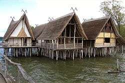 Reconstructed pile dwellings in Unteruhldingen
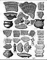 Patterns of pile dwellings ceramics, Lake Bourget, Savoy, 1915
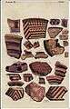 Ceramics of palafittes of Lake Bourget, Savoy, 1915
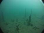 Remains of underwater palafittes, station of Morges, Switzerland, 2011
 Inventory of the metallic material of the pile dwellings of Lake Bourget, 1908
 Canoe from Lake Chalain, Jura, 1904
 Site of pile dwellings near Ig, Slovenia
See also
- Prehistoric pile dwellings around Zürichsee
References
- UNESCO World Heritage Site - Prehistoric Pile dwellings around the Alps
- Maša Štiftar de Arzu, ed. (14 October 2011). "Pile-dwellings in the Ljubljansko Barje on UNESCO List" (PDF). Embassy Newsletter. Embassy of Slovenia in Washington.
- Armando Mombelli, Lake dwellings reveal hidden past, SwissInfo.ch, Nov 11, 2011
- Prehistoric Pile dwellings around the Alps, Locations accessed 12 August 2011. Due to errors in coordinates from this document, some coordinates come from other sources.
- Location and coordinates taken from Palafittes.org nominating documents-Revised executive summary Archived 2012-03-30 at the Wayback Machine accessed 12 August 2011. Coordinates converted from UTM.
- palafittes.org nomination documents Archived 2012-03-30 at the Wayback Machine accessed 14 August 2011
External links
| Wikimedia Commons has media related to Prehistoric pile dwellings around the Alps World Heritage Site. |
| Wikivoyage has a travel guide for Prehistoric Pile Dwellings around the Alps. |
| Flag of Austria | |

See also List of World Heritage Sites in Slovenia. | ||
| Cultural | ||
| Natural | ||
World Heritage Sites in Switzerland | ||
|---|---|---|
| Lake Geneva region | Flag of Switzerland | |
| Espace Mittelland |
| |
| Eastern |
| |
| Ticino | ||
| Nationwide | ||