Wetzikon
Wetzikon is a small town in the Zurich Highlands (Zürcher Oberland) area of Switzerland, in the district of Hinwil in the canton of Zürich.
Wetzikon | |
|---|---|
 | |
 Coat of arms | |
Location of Wetzikon 
| |
 Wetzikon Wetzikon | |
| Coordinates: 47°19′N 8°48′E | |
| Country | Switzerland |
| Canton | Zurich |
| District | Hinwil |
| Government | |
| • Executive | Gemeinderat with 7 members |
| • Mayor | Gemeindepräsident Urs Fischer FDP/PRD (as of March 2014) |
| • Parliament | Grosser Gemeinderat with 36 members |
| Area | |
| • Total | 16.73 km2 (6.46 sq mi) |
| Elevation | 535 m (1,755 ft) |
| Population (2018-12-31)[2] | |
| • Total | 24,803 |
| • Density | 1,500/km2 (3,800/sq mi) |
| Postal code | 8620 |
| SFOS number | 0121 |
| Localities | Ettenhausen, Kempten, Medikon, Oberwetzikon, Robenhausen, Unterwetzikon |
| Surrounded by | Bäretswil, Gossau, Hinwil, Mönchaltorf, Pfäffikon, Seegräben |
| Twin towns | Melnik (Czech Republic) |
| Website | www SFSO statistics |
Geography


The municipality Wetzikon has an area of 16.7 km2 (6.4 sq mi). Of this area, 42.4% is used for agricultural purposes, while 17.6% is forested. Of the rest of the land, 27.9% is settled (buildings or roads) and the remainder (12.1%) is non-productive (streams, lakes and non-productive vegetation).[3] In 1996 housing and buildings made up 20% of the total area, while transportation infrastructure made up the rest (7.9%).[4] Of the total unproductive area, water (streams and lakes) made up 3.3% of the area. As of 2007 30.5% of the total municipal area was undergoing some type of construction.[4]
It is located near Lake Pfäffikon in the Zürcher Oberland, between Uster and Rapperswil-Jona.
The Robenhauser Ried wetland is a nature reserve of national importance and is situated between Seegräben, Kempten and Irgenhausen covering an area of about two square kilometers.
Demographics
Wetzikon has a population (as of 31 December 2018) of 24,809.[5] As of 2007, 22.1% of the population was made up of foreign nationals. As of 2008 the gender distribution of the population was 49.2% male and 50.8% female. Over the last 10 years the population has grown at a rate of 18.8%. Most of the population (as of 2000) speaks German (83.8%), with Italian being second most common ( 5.7%) and Albanian being third ( 1.9%).
| Nationalities in Wetzikon | End of 2010[6] | End of 2011[7] |
|---|---|---|
| 76,8 % | 76,5 % | |
| 5,5 % | 5,2 % | |
| 3,9 % | 3,9 % | |
| 2,4 % | 2,6 % | |
| 1,7 % | 1,7 % | |
| 1,8 % | 1,7 % | |
| 1,2 % | 1,4 % | |
| 1,1 % | 1,1 % |
In the 2007 election the most popular party was the SVP which received 37.6% of the vote. The next three most popular parties were the SPS (16.1%), the CSP (12.2%) and the Green Party (10.5%).
The age distribution of the population (as of 2000) is children and teenagers (0–19 years old) make up 23.1% of the population, while adults (20–64 years old) make up 62% and seniors (over 64 years old) make up 15%.[3] There are 7929 households in Wetzikon.[4]
_ShiftN.jpg)
As of 2008 there were 6385 Catholics and 7772 Protestants in Wetzikon. In the 2000 census, religion was broken down into several smaller categories. From the 2000 census, 45% were some type of Protestant, with 40.3% belonging to the Swiss Reformed Church and 4.7% belonging to other Protestant churches. 31.3% of the population were Catholic. Of the rest of the population, 6.5% were Muslim, 8.7% belonged to another religion (not listed), 3.6% did not give a religion, and 10.6% were atheist or agnostic.[4]
Economics and education
The Kantonschule Zürcher Oberland (KZO),[8] or the "Kanti" as the gymnasium level learning institution is known in Swiss German, is based in Wetzikon due to its central location in the Zürich Oberland, as well as the Zürcher Oberländer newspaper and the annual ZOM trade fair.[9]
The regional hospital, the Gesundheitsversorgung Zürcher Oberland [10] is also located there.
Wetzikon has an unemployment rate of 2.9%. As of 2005, there were 134 people employed in the primary economic sector and about 41 businesses involved in this sector. 3486 people are employed in the secondary sector and there are 255 businesses in this sector. 7054 people are employed in the tertiary sector, with 838 businesses in this sector.[3] As of 2007 43.8% of the working population were employed full-time, and 56.2% were employed part-time.[4]
In Wetzikon about 69.4% of the population (between age 25-64) have completed either non-mandatory upper secondary education or additional higher education (either university or a Fachhochschule).[3]
World heritage site
The prehistoric settlement Wetzikon–Robenhausen at the Robenhausen wetland which was discovered and researched by Jakob Messikommer is part of the serial site Prehistoric Pile dwellings around the Alps, an UNESCO World Heritage Site.[11]
Transportation
There are two railway stations within the municipality. Wetzikon railway station is a node of the Zürich S-Bahn on the lines S3, S14, S15 and S5. Kempten railway station is on the S3 line only. The town is a 20-minute (S5) ride from Zürich Hauptbahnhof.
Gallery
 Kempten, Bachtel in the background
 Apartments buildings in Oberwetzikon, Alps in the background
 Robenhuserriet in Robenhausen
_IMG_4901.jpg) Aabach in Wetzikon
Aabach in Wetzikon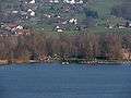 Auslikon and its Strandbad (lido) on Lake Pfäffikon shore
 Schloss (castle) Wetzikon
 Bahnhofstrasse between Oberwetzikon and Kempten
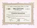 Bond of the municipality Wetzikon, issued 29. October 1900
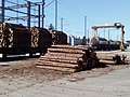 lumber with railroad cars (Wetzikon station)
 S-train (Wetzikon station)
History

The oldest surviving document about the name Wetzikon is from the year 1044, where three nobles of "Wezzinchova" are mentioned; before that the village and castle were known by the name Ratpoldskilch.[12] Older history is known from excavations of prehistoric pile dwellings in Robenhausen and a Roman villa rustica in Kempten.[13]
Sights
- The local museum (Ortsmuseum) documents the cultural history from the Neolithic Age until the 21st century [14]
- Robenhauser Riet
- Kemptner Tobel
Notable persons


- Elisabeth of Wetzikon (1235-1298) imperial abbess of the Fraumünster abbey 1270-1298
- Johannes Schmidlin (1722-1772) pastor and composer
- Hans Georg Nägeli (1773-1836) composer and music publisher
- Heinrich Leuthold (1827-1879) poet and translator
- Jakob Messikommer (1828-1917) wetland archaeologist, researched the settlement at Robenhausen
- Jakob Heusser (1862–1941) industrialist and philanthropist
- Hedi Lang (1931-2004) politician, second woman to preside in the Swiss National Council
- Jörg Schneider (1935-2015) stage and film actor [15]
- Walter Andreas Müller (born 1945) stage and film actor, radio host and comedian [16]
- Ueli Maurer (born 1950), politician, member of the Swiss Federal Council
- Eric Franklin (born 1957) dancer, movement educator, university lecturer and writer
- Patrick Mohr (born 1971) former professional tennis player
- Andreas Schweizer (born 1979) gymnast [17]
- Dorothee Elmiger (born 1985), writer
- Steven Deana (born 1990) football goalkeeper currently playing for FC Aarau
- Natalie Kanyapak Phoksomboon (born 1991) Thai-Swiss beauty queen, won Miss Thailand World 2013
References
- "Arealstatistik Standard - Gemeinden nach 4 Hauptbereichen". Federal Statistical Office. Retrieved 13 January 2019.
- "Ständige Wohnbevölkerung nach Staatsangehörigkeitskategorie Geschlecht und Gemeinde; Provisorische Jahresergebnisse; 2018". Federal Statistical Office. 9 April 2019. Retrieved 11 April 2019.
- Swiss Federal Statistical Office accessed 06-Aug-2009
- Statistics Zurich (in German) accessed 4 August 2009
- Swiss Federal Statistical Office - STAT-TAB, online database – Ständige und nichtständige Wohnbevölkerung nach institutionellen Gliederungen, Geburtsort und Staatsangehörigkeit (in German) accessed 23 September 2019
- http://www.wetzikon.ch/Verwaltung/Einwohnerdienste/bevoelkerungsstatistiken/Statistik%202008.pdf/at_download/file (Retrieved 27 February 2012).
- http://www.wetzikon.ch/Verwaltung/Einwohnerdienste/bevoelkerungsstatistiken/Jahresstatistik%20Homepage.pdf/at_download/file (Retrieved 5 March 2012).
- Kantonschule Zürcher Oberland (KZO) (in German)
- Zürcher Oberland Messe (in Swiss-German "Züri Oberland Mäss") (in German)
- Gesundheitsversorgung Zürcher Oberland (in German)
- UNESCO World Heritage Site - Prehistoric Pile dwellings around the Alps
- Altdorfer, Werner (1987). Rund um den Bachtel - Heimatkundliches aus dem Zürcher Oberland (in German). Wetzikon: Buchverlang der Druckerei Wetzikon AG. ISBN 3-85981-138-X.
- Horisberger, Beat; Hedinger, Bettina; Hoek, Florian; Büsser, Roger (2007). Römisches Landleben im Zürcher Oberland - Die Römer in Wetzikon (in German). Frauenfeld, Stuttgart, Wien: Verlag Huber. ISBN 978-3-7193-1441-5.
- Museum Wetzikon (in German)
- IMDb Database retrieved 27 December 2018
- IMDb Database retrieved 27 December 2018
- German Wiki, Andreas Schweizer
External links
| Wikimedia Commons has media related to Wetzikon. |
- Official website (in German)
- Community website (in German)
| Authority control |
|
|---|