Pottawatomie County, Oklahoma
Pottawatomie County is a county located in the U.S. state of Oklahoma. As of the 2010 census, the population was 69,442.[1] Its county seat is Shawnee.[2]
Pottawatomie County | |
|---|---|
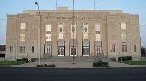 Pottawatomie County Courthouse in Shawnee | |
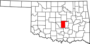 Location within the U.S. state of Oklahoma | |
 Oklahoma's location within the U.S. | |
| Coordinates: 35°12′N 96°56′W | |
| Country | |
| State | |
| Founded | 1891 |
| Named for | Potawatomi people |
| Seat | Shawnee |
| Largest city | Shawnee |
| Area | |
| • Total | 793 sq mi (2,050 km2) |
| • Land | 788 sq mi (2,040 km2) |
| • Water | 5.7 sq mi (15 km2) 0.7%% |
| Population | |
| • Estimate (2018) | 72,679 |
| • Density | 88/sq mi (34/km2) |
| Time zone | UTC−6 (Central) |
| • Summer (DST) | UTC−5 (CDT) |
| Congressional district | 5th |
| Website | pottawatomiecountyok |
Pottawatomie County is part of the Shawnee, OK Micropolitan Statistical Area, which is included in the Oklahoma City–Shawnee, OK Combined Statistical Area.
History
Pottawatomie County was carved out of land originally given to the Creek and Seminole after their forced removal from Georgia and Florida. After the Civil War, the Creek and Seminole were forced to cede their lands back to the federal government, and the area of Pottawatomie County was used to resettle the Iowa, Sac and Fox, Absentee Shawnee, Potawatomi and Kickapoo tribes.[3]
Non-Indian settlement began on September 22, 1891 when all the tribes except the Kickapoo agreed to land allotment, where communal reservation land was divided and allotted to individual members of the tribes. The remaining land was opened to settlement.[3]
During the land run, Pottawatomie County was organized as County "B" with Tecumseh as the county seat. In 1892, the voters of the county elected to rename County "B" as Pottawatomie County after the Potawatomi Indians.
In 1895, the Kickapoo gave up their land rights and their land was given away to white settlers in the last land run in Oklahoma.
In 1930, Shawnee, now bigger in size than Tecumseh, was approved by the voters to become the new county seat. The Pottawatomie County Court House was built in 1934 by the Public Works Administration. The court house project cost $250,000.00 to complete.[3]
On May 19, 2013, during an outbreak of tornadoes, a mobile home park was nearly destroyed killing a 79-year-old man and injuring at least 6 others as well as damaging at least 35 structures. Frame and brick homes west of Shawnee were also affected.[4]
Geography
According to the U.S. Census Bureau, the county has a total area of 793 square miles (2,050 km2), of which 788 square miles (2,040 km2) is land and 5.7 square miles (15 km2) (0.7%) is water.[5]
Adjacent counties
- Lincoln County (north)
- Okfuskee County (northeast)
- Seminole County (east)
- Pontotoc County (southeast)
- McClain County (southwest)
- Cleveland County (west)
- Oklahoma County (northwest)
Demographics
| Historical population | |||
|---|---|---|---|
| Census | Pop. | %± | |
| 1900 | 26,412 | — | |
| 1910 | 43,595 | 65.1% | |
| 1920 | 46,028 | 5.6% | |
| 1930 | 66,572 | 44.6% | |
| 1940 | 54,377 | −18.3% | |
| 1950 | 43,517 | −20.0% | |
| 1960 | 41,486 | −4.7% | |
| 1970 | 43,134 | 4.0% | |
| 1980 | 55,239 | 28.1% | |
| 1990 | 58,760 | 6.4% | |
| 2000 | 65,521 | 11.5% | |
| 2010 | 69,442 | 6.0% | |
| Est. 2018 | 72,679 | [6] | 4.7% |
| U.S. Decennial Census[7] 1790-1960[8] 1900-1990[9] 1990-2000[10] 2010-2013[1] | |||
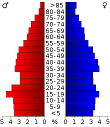
As of the census of 2010,[11] there were 69,442 people, 25,911 households, and 18,227 families residing in the county. The population density was 34/km² (88/mi²). There were 29,139 housing units at an average density of 14/km² (37/mi²). The racial makeup of the county was 76.3% white, 2.9% black or African American, 12.9% Native American, 0.6% Asian, 0.1% Pacific Islander, 0.1% from other races, and 6.3% from two or more races. About 4% of the population were Hispanic or Latino of any race, while 9% were of American, 17% German, 14% Irish and 10% English ancestry according to 2010 census. About 90.6% spoke English and 4.2% Spanish as their first language.
There were 25,911 households, out of which 34.5% included children under the age of 18, 51.9% were married couples living together, 13.3% had a female householder with no husband present, 5.1% had a male householder with no wife present, and 29.7% were non-families. About a quarter of households consisted of a single individual and 9.8% had someone living alone who was 65 years of age or older. The average household size was 2.56 and the average family size was 3.04.
In the county, the population was spread out with 25% under the age of 18, 10.2% from 18 to 24, 24.6% from 25 to 44, 25.9% from 45 to 64, and 14.3% who were 65 years of age or older. The median age was 37 years. For every 100 females, there were 92.1 males. For every 100 females age 18 and over, there were 88 males.
The median income for a household in the county was $41,332, and the median income for a family was $50,399. Males had a median income of $39,580 versus $27,495 for females. The per capita income for the county was $20,700. About 14% of families and 18% of the population were below the poverty line, including 26.4% of those under age 18 and 10.3% of those age 65 or over.
Government and infrastructure
The Pioneer Library System operates branch libraries in nine cities in Pottawatomie, Cleveland, and McClain counties.[12]
The Oklahoma Department of Corrections operates the Mabel Bassett Correctional Center in an unincorporated area in the county, near McLoud.[13]
Politics
| Voter Registration and Party Enrollment as of January 15, 2019[14] | |||||
|---|---|---|---|---|---|
| Party | Number of Voters | Percentage | |||
| Democratic | 13,438 | 34.97% | |||
| Republican | 18,628 | 48.47% | |||
| Others | 6,363 | 16.56% | |||
| Total | 38,429 | 100% | |||
| Year | Republican | Democratic | Third parties |
|---|---|---|---|
| 2016 | 70.1% 17,848 | 23.6% 6,015 | 6.2% 1,589 |
| 2012 | 69.3% 16,250 | 30.7% 7,188 | |
| 2008 | 69.2% 17,753 | 30.8% 7,910 | |
| 2004 | 66.6% 17,215 | 33.4% 8,638 | |
| 2000 | 59.3% 13,235 | 39.3% 8,763 | 1.4% 318 |
| 1996 | 45.1% 9,802 | 42.0% 9,141 | 12.9% 2,810 |
| 1992 | 40.5% 10,350 | 33.7% 8,616 | 25.8% 6,606 |
| 1988 | 57.2% 12,099 | 41.9% 8,873 | 0.9% 197 |
| 1984 | 69.4% 16,143 | 30.0% 6,966 | 0.7% 152 |
| 1980 | 57.1% 12,466 | 39.0% 8,526 | 3.9% 858 |
| 1976 | 44.2% 9,090 | 54.7% 11,255 | 1.1% 226 |
| 1972 | 71.3% 13,308 | 25.8% 4,822 | 2.9% 534 |
| 1968 | 39.4% 6,899 | 38.4% 6,721 | 22.1% 3,873 |
| 1964 | 38.6% 6,841 | 61.4% 10,884 | |
| 1960 | 53.9% 9,421 | 46.1% 8,067 | |
| 1956 | 48.9% 8,496 | 51.2% 8,895 | |
| 1952 | 51.7% 10,099 | 48.4% 9,455 | |
| 1948 | 31.8% 4,760 | 68.2% 10,220 | |
| 1944 | 41.4% 6,486 | 58.3% 9,130 | 0.3% 43 |
| 1940 | 35.8% 6,776 | 63.8% 12,058 | 0.4% 78 |
| 1936 | 27.7% 4,703 | 71.8% 12,187 | 0.5% 78 |
| 1932 | 25.3% 4,063 | 74.7% 12,013 | |
| 1928 | 68.6% 8,478 | 30.7% 3,797 | 0.7% 89 |
| 1924 | 38.8% 4,040 | 48.7% 5,072 | 12.5% 1,297 |
| 1920 | 47.6% 5,355 | 47.2% 5,310 | 5.3% 595 |
| 1916 | 31.6% 2,042 | 50.6% 3,276 | 17.8% 1,155 |
| 1912 | 33.8% 2,107 | 49.4% 3,082 | 16.9% 1,054 |
Transportation
Major highways
.svg.png)


Airport
The Shawnee Regional Airport is located 2 nautical miles (3.7 km) northwest from the central business district of Shawnee. It is classified as a general aviation airport.
Communities
Cities
- Oklahoma City (mostly in Oklahoma County)
- Shawnee (county seat)
- Tecumseh
Towns
Census-designated place
Other unincorporated communities
- Aydelotte
- Bellemont
- Harjo
- Pearson
- Romulus
- Sacred Heart
NRHP Sites
The following sites in Pottawatomie County are listed on the National Register of Historic Places:
|
|
References
- "State & County QuickFacts". United States Census Bureau. Archived from the original on January 12, 2016. Retrieved November 12, 2013.
- "Find a County". National Association of Counties. Retrieved June 7, 2011.
- Willam H. Mullins, "Pottawatomie County," Encyclopedia of Oklahoma History and Culture, Accessed April 4, 2015.
- Lackey, Katharine; Welch, William M. (May 19, 2013). "Tornadoes hit Plains, Midwest; 1 dead in Okla". USA Today. Retrieved May 20, 2013.
- "2010 Census Gazetteer Files". United States Census Bureau. August 22, 2012. Retrieved February 22, 2015.
- "Population and Housing Unit Estimates". Retrieved December 26, 2019.
- "U.S. Decennial Census". United States Census Bureau. Retrieved February 22, 2015.
- "Historical Census Browser". University of Virginia Library. Retrieved February 22, 2015.
- Forstall, Richard L., ed. (March 27, 1995). "Population of Counties by Decennial Census: 1900 to 1990". United States Census Bureau. Retrieved February 22, 2015.
- "Census 2000 PHC-T-4. Ranking Tables for Counties: 1990 and 2000" (PDF). United States Census Bureau. April 2, 2001. Retrieved February 22, 2015.
- "U.S. Census website". United States Census Bureau. Retrieved January 31, 2008.
- "Pioneer Library System to buy Borders bookstore building in Norman". NewsOK. The Oklahoman. September 27, 2011. Retrieved October 25, 2011.
- "Mabel Bassett Correctional Center Archived December 21, 2010, at the Wayback Machine." Oklahoma Department of Corrections. Retrieved on November 22, 2010.
- "Oklahoma Registration Statistics by County" (PDF). OK.gov. January 15, 2019. Retrieved 2019-02-27.
- Leip, David. "Dave Leip's Atlas of U.S. Presidential Elections". uselectionatlas.org. Retrieved March 30, 2018.
External links
- Pottawatomie County Sheriff's Office
- Pottawatomie County, Oklahoma
- Charles W. Mooney Jr., Localized History of Pottawatomie County, Oklahoma to 1907, 1971
Places adjacent to Pottawatomie County, Oklahoma | ||||||||||
|---|---|---|---|---|---|---|---|---|---|---|
| ||||||||||
Municipalities and communities of Pottawatomie County, Oklahoma, United States | ||
|---|---|---|
| Cities | Pottawatomie County map | |
| Towns | ||
| CDP | ||
| Other unincorporated communities | ||
| Ghost towns | ||
| Footnotes | ‡This populated place also has portions in an adjacent county or counties | |
Oklahoma City (capital) | ||
| Topics |
|  |
| Society |
| |
| Regions | ||
| Largest cities | ||
| Counties |
| |
| Authority control |
|
|---|