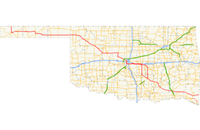
Oklahoma State Highway 3
State Highway 3, also abbreviated as SH-3 or OK-3, is a highway maintained by the U.S. state of Oklahoma. Traveling diagonally through Oklahoma, from the Panhandle to the far southeastern corner of the state, SH-3 is the longest state highway in the Oklahoma road system, at a total length of 615 miles (990 km) via SH-3E (see below).
| ||||
|---|---|---|---|---|
 | ||||
| Route information | ||||
| Maintained by ODOT | ||||
| Length | 615.0 mi[1][2][3] (989.7 km) | |||
| Existed | 1939–present | |||
| Major junctions | ||||
| West end | ||||
| East end | ||||
| Highway system | ||||
Oklahoma State Highway System
| ||||

Route description
In the northwest
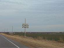
Highway 3 begins at the Colorado state line 19 mi (31 km) north of Boise City, Oklahoma. At this terminus, it is concurrent with US-287/US-385. It remains concurrent with the two U.S. Routes until reaching Boise City, where it encounters a traffic circle which contains five other highways. After the circle, US-385 splits off, and SH-3 overlaps US-287, US-56, US-64, and US-412, though US-56 and US-287 both split off within the next 8 miles (13 km).
In Guymon, US-64 splits off. At Elmwood, US-270 joins US-412, coming from a concurrency with State Highway 23. SH-3 remains concurrent with US-270 through Watonga. In Seiling, US-183 leaves the concurrency but is quickly replaced by U.S. Highway 281. SH-33 joins the roadbed 20 miles (32 km) later.
In Watonga, SH-33 and SH-3 split off from US-270 and US-281. Highways 3 and 33 remain concurrent for 28 more miles, until Kingfisher, where SH-3 joins U.S. Highway 81. It will stay concurrent with US-81 for 13 miles (21 km), through the town of Okarche. Three miles after Okarche, SH-3 leaves US-81. This marks the first point that SH-3 has not been part of a concurrency.
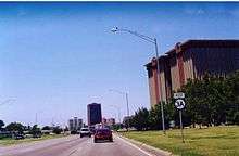
Through Oklahoma City
Beginning at the split from US-81, Highway 3 becomes a major artery in the Oklahoma City highway system, commonly known as the Northwest Expressway because it is a diagonal route and because it serves the northwestern part of the metro area. It skirts the northern limits of El Reno before entering the Oklahoma City limits. The often-congested Northwest Expressway passes through the suburb of Warr Acres and passes close to Lake Hefner.
At the intersection with the Lake Hefner Parkway, SH-3 again re-enters a concurrency. The Lake Hefner Parkway ends very shortly after, and SH-3 becomes concurrent with Interstate 44 through the western side of the city. Near Will Rogers World Airport, Highway 3 transfers to I-240 along the southern side of the city. After I-240 ends, SH-3 is transferred onto I-40 (also carrying US-270), which it remains concurrent with for 16 miles (26 km).
SH-3E/3W split
In Shawnee, SH-3 splits into two highways, SH-3E and SH-3W. SH-3W splits off I-40 onto U.S. Highway 177, along with US-270, at I-40 milemarker 181. It continues along with US-270 and 177 through the west side of Shawnee, and continues south of that city until Tecumseh, where US-270 splits off. South of Asher, Oklahoma, SH-3W leaves US-177 and veers southeast toward Ada.
SH-3E, the longer of the two split routes, was the original routing of Highway 3 before the two highways were split. It remains on I-40 for five miles (8 km) after SH-3W splits off. When it does split off, it soon joins SH-18. It follows a route closer to the center of Shawnee. After leaving Shawnee, it heads southeast toward Seminole. Here, it meets US-377/SH-99. SH-3E merges onto this highway, and they will remain concurrent until after they reach Ada.
In Ada, SH-3E and SH-3W are reunited and become SH-3 once again.
Ada to Atoka

SH-3 then becomes part of the Richardson Loop, a freeway around the west and south sides of Ada. Throughout the Richardson Loop, it overlaps SH-1 and US-377/SH-99 at different times. The highway then becomes two-lane once again and heads southeast to the town of Coalgate, where begins an 18-mile (29 km) concurrency with U.S. Highway 75, lasting through Atoka. In Atoka, US-75 splits off to join U.S. Highway 69.
Antlers to Arkansas
Two miles west of Antlers, the highway has an interchange with the Indian Nation Turnpike, and in Antlers it intersects U.S. Highway 271. After reaching the town of Broken Bow, Oklahoma, it turns southward and overlaps US-259 and US-70.
Near Idabel, the highway splits off after being with US-259 for 13 mi (21 km). Twenty-eight miles later, it becomes Highway 32 as it crosses the state line into Arkansas.
History
The current SH-3 was designated on 15 May 1939. The original highway included all of current SH-3 up to Antlers, where it terminated at US-271. It was extended to the Arkansas state line on 4 August 1952. SH-3 ended there concurrent with US-70 and SH-7, near DeQueen, Arkansas. On 7 January 1963, the highway was given its own alignment from near Idabel to Arkansas, taking over that of SH-21, which was eliminated at that time.
From the highway's commissioning to 1976, there was only one fork of SH-3 between Shawnee and Ada, which was the path of current SH-3E. SH-3W and SH-3E were created on 4 October 1976; the new SH-3W took over all of SH-13. Other than minor realignments, the highway remains essentially the same today.[4]
In the early 1980s, Governor George Nigh was able to obtain $97.1 million to upgrade the highway between Oklahoma City and Colorado, despite opponents labeling the project "the highway to nowhere".[5] House Concurrent Resolution 1067 labeled the highway as "Governor George Nigh's Northwest Passage." ODOT officially named the highway on 2 February 1981.[6]
Notes
- SH-3's concurrency with Interstate 44 in Oklahoma City is an example of a wrong-way concurrency – I-44 West is SH-3 East and vice versa.
- SH-3's concurrency with US-70 is also a wrong-way concurrency, as US-70 is signed as going west and SH-3 as going east.
- The SH-3 bypass around Atoka is named the Cecil B. "Bud" Greathouse Bypass. It was designated by ODOT on 4 October 1982.[7]
SH-3A

SH-3 had one lettered spur, SH-3A, which continued the alignment of the Northwest Expressway for two more miles before ending at Interstate 44 near Penn Square Mall. It was originally known as SH-66A, a spur off U.S. Highway 66, which once ran through the area. The combined effect of US-66 being decommissioned and "3A" being a more logical name for an extension of Highway 3 led to the name change. State Highway 3A was decommissioned in 2009.
Junction list
| County | Location | mi[1][3] | km | Exit | Destinations | Notes | ||
|---|---|---|---|---|---|---|---|---|
| Cimarron | | 0.00 | 0.00 | Continuation into Colorado; western end of US-287/US-385 concurrency | ||||
| | 17.6 | 28.3 | Eastern end of US-287 concurrency | |||||
| Boise City | 18.5 | 29.8 | Traffic circle around Cimarron County Courthouse; eastern terminus of SH-325; eastern end of US-385 concurrency; western end of US-56/US-64/US-412 concurrency | |||||
| | 20.3 | 32.7 | Diamond interchange; US-287 exit 21 | |||||
| | 26.4 | 42.5 | Eastern end of US-56 concurrency | |||||
| | 34.1 | 54.9 | ||||||
| Texas | Four Corners | 53.0 | 85.3 | Western end of SH-95 concurrency | ||||
| | 58.0 | 93.3 | Eastern end of SH-95 concurrency | |||||
| | 76.1 | 122.5 | Western end of SH-136 concurrency | |||||
| Guymon | 80.4 | 129.4 | Eastern end of US-64 concurrency; western terminus of US-412 Truck/SH-3 Truck; northern terminus of SH-136 Truck | |||||
| 81.2 | 130.7 | Western end of US-54 concurrency | ||||||
| 81.6 | 131.3 | Eastern end of US-54 concurrency; eastern terminus of US-412 Truck/SH-3 Truck; southern terminus of SH-136 Truck | ||||||
| 81.65 | 131.40 | Eastern end of SH-136 concurrency | ||||||
| | 96.2 | 154.8 | Southern terminus of SH-94 | |||||
| Beaver | Bryan's Corner | 119.2 | 191.8 | |||||
| Elmwood | 136.1 | 219.0 | Western end of US-270 concurrency | |||||
| Harper | | 171.3 | 275.7 | |||||
| May | 179.5 | 288.9 | ||||||
| Ellis |
No major junctions | |||||||
| Woodward | | 188.9 | 304.0 | Western end of US-183 concurrency | ||||
| Woodward | 202.8 | 326.4 | Eastern terminus of SH-15 | |||||
| 204.9 | 329.8 | Eastern end of US-412 concurrency; western end of SH-34 concurrency | ||||||
| | 208.7 | 335.9 | Eastern end of SH-34 concurrency | |||||
| | 217.5 | 350.0 | Southern terminus of SH-50 | |||||
| Dewey | | 236.0 | 379.8 | Eastern end of US-183 concurrency | ||||
| Seiling | 238.1 | 383.2 | Northern end of US-60/US-281 concurrency | |||||
| 238.7 | 384.2 | Southern end of US-60 concurrency; western end of SH-51 concurrency | ||||||
| Hucmac | 247.1 | 397.7 | Eastern end of SH-51 concurrency | |||||
| Blaine | | 266.9 | 429.5 | Western end of SH-33 concurrency; southern terminus of SH-58 | ||||
| Watonga | 276.5 | 445.0 | Eastern end of US-270/US-281 concurrency | |||||
| Kingfisher | Kingfisher | 304.1 | 489.4 | Eastern end of SH-33 concurrency; western end of US-81 concurrency | ||||
| Canadian | | 316.4 | 509.2 | Trumpet interchange; eastern end of US-81 concurrency | ||||
| Oklahoma City | 329.9 | 530.9 | ||||||
| 333.5 | 536.7 | Diamond interchange | ||||||
| Oklahoma | 340.4 | 547.8 | Diamond interchange; west end of freeway section; western end of SH-74 (Lake Hefner Pkwy.) concurrency | |||||
| 341.1 | 548.9 | — | NW 50th Street | |||||
| 341.9 | 550.2 | 123B | Stack interchange; exit numbers follow I-44 | |||||
| 341.9 | 550.2 | — | Stack interchange; I-44 exit 123B; southern terminus of SH-74; northern end of I-44 concurrency | |||||
| 342.4 | 551.0 | 123A | NW 36th Street | Westbound exit and eastbound entrance | ||||
| 343.2 | 552.3 | 122 | NW 23rd Street | |||||
| 344.2 | 553.9 | 121A-B | NW 10th Street – Fair Park | Signed as exits 121B (west) and 121A (east); Fair Park signed westbound only | ||||
| 345.5 | 556.0 | 120A-B | Full diamond interchange; signed as exits 120B (east) and 120A (west) | |||||
| 346.3 | 557.3 | 119 | SW 15th Street | |||||
| 347.3 | 558.9 | 118 | SW 29th Street | |||||
| 348.1 | 560.2 | 117A | SW 44th Street | Signed as exit 117B northbound | ||||
| 348.6 | 561.0 | 116B | Eastern terminus of SH-152 | |||||
| 349.4 | 562.3 | 116A | SW 59th Street | |||||
| 350.0 | 563.3 | 1A | Exit number follows I-240; southern end of I-44 concurrency; western end of I-240/US-62 concurrency; western terminus of I-240 | |||||
| Overlap with I-240 | ||||||||
| 366.8 | 590.3 | — | Eastern terminus of I-240; I-40 exit 165; eastern end of I-240 concurrency; western end of I-40/US-270 concurrency | |||||
| 368.1 | 592.4 | 166 | Choctaw Road | Exit numbers follow I-40 | ||||
| 371.2 | 597.4 | 169 | Peebly Road | |||||
| 374.0 | 601.9 | 172 | Harrah Newalla Road | |||||
| Pottawatomie | McLoud | 378.1 | 608.5 | 176 | Western end of SH-102 concurrency | |||
| Dale | 380.2 | 611.9 | 178 | Eastern end of SH-102 concurrency | ||||
| Shawnee | 382.9 | 616.2 | 181 | SH-3 east splits into SH-3W and SH-3E; eastern end of I-40/US-270 concurrency; exit number is for US-177/US-270/SH-3W | ||||
| See SH-3E and SH-3W | ||||||||
| Pontotoc | | 440.4 | 708.8 | — | West end of freeway section; northern end of SH-1 concurrency; SH-3 west splits into SH-3W and SH-3E | |||
| | Ada | Westbound exit only | ||||||
| | 440.9 | 709.6 | — | Reeves Road | Eastbound exit only | |||
| | 441.3 | 710.2 | — | Southern end of SH-1 concurrency | ||||
| | 442.3 | 711.8 | — | Oak Avenue | Eastbound exit and westbound entrance | |||
| | 443.4 | 713.6 | — | Kerr Lab Road | ||||
| Ada | 444.4 | 715.2 | — | Western end of US-377/SH-99 concurrency; westbound exit and eastbound entrance | ||||
| 445.3 | 716.6 | — | Stonecipher Boulevard | |||||
| Ahloso | 446.2 | 718.1 | — | East end of freeway; eastern end of US-377/SH-99 concurrency | ||||
| | 454.9 | 732.1 | Stonewall | Interchange | ||||
| Coal | | 461.5 | 742.7 | |||||
| | 471.1 | 758.2 | Western end of US-75 concurrency | |||||
| Coalgate | 474.9 | 764.3 | Northern end of SH-31 concurrency | |||||
| 475.0 | 764.4 | Southern end of SH-31 concurrency | ||||||
| 475.4 | 765.1 | Western terminus of SH-43 | ||||||
| Atoka | Atoka | Western terminus of SH-3 Byp. | ||||||
| 488.2 | 785.7 | Western end of US-69 concurrency | ||||||
| 489.6 | 787.9 | Eastern end of US-69/US-75 concurrency; eastern terminus of SH-3 Byp./SH-7 | ||||||
| Pushmataha | Antlers | 519.8 | 836.5 | Interchange; Indian Nation Tpk. exit 16 | ||||
| 520.5 | 837.7 | Southern terminus of SH-2 | ||||||
| 521.5 | 839.3 | Western end of US-271 concurrency | ||||||
| 522.4 | 840.7 | Eastern end of US-271 concurrency | ||||||
| Rattan | 534.2 | 859.7 | Northern terminus of SH-93 | |||||
| Oleta | 538.3 | 866.3 | Northern terminus of SH-147 | |||||
| McCurtain | | 565.9 | 910.7 | Northern terminus of SH-98 | ||||
| Broken Bow | 577.0 | 928.6 | Northern end of US-70/US-259 concurrency | |||||
| Idabel | 584.8 | 941.1 | Southern end of US-70 concurrency; northern end of US-70 Byp. concurrency | |||||
| 586.7 | 944.2 | Eastern end of US-259 concurrency; southern end of US-70 Byp. concurrency | ||||||
| | 615.0 | 989.7 | Continuation into Arkansas | |||||
1.000 mi = 1.609 km; 1.000 km = 0.621 mi
| ||||||||
SH-3E
| County | Location | mi[2] | km | Exit | Destinations | Notes |
|---|---|---|---|---|---|---|
| Pottawatomie | | 387.0 | 622.8 | 181 | Exit numbers follow I-40; eastern end of I-40 concurrency; SH-3E west and SH-3W merge into SH-3 | |
| Shawnee | 185 | Kickapoo Street – Shawnee | ||||
| 389.7 | 627.2 | Western end of SH-18 concurrency; I-40 exit 186 | ||||
| 391.7 | 630.4 | Eastern end of SH-18 concurrency | ||||
| Earlsboro | 397.6 | 639.9 | ||||
| | 398.9 | 642.0 | Western terminus of SH-99A | |||
| Seminole | Seminole | 406.5 | 654.2 | Western end of US-270 concurrency | ||
| 408.9 | 658.1 | eastern end of US-270 concurrency, western end of US-377/SH-99 concurrency | ||||
| 411.4 | 662.1 | Western end of SH-59 concurrency | ||||
| Bowlegs | 414.1 | 666.4 | Eastern end of SH-59 concurrency | |||
| | 428.5 | 689.6 | Eastern terminus of SH-39; western terminus of SH-56 | |||
| Canadian River | Haney-Abbott Bridge | |||||
| Pontotoc | Ada | 439.4 | 707.1 | — | West end of freeway; eastern end of US-377/SH-99 concurrency, western end of SH-1 concurrency | |
| | 440.4 | 708.8 | — | Eastbound exit and westbound entrance; eastern terminus of SH-19 | ||
| | Ada | Eastbound exit and westbound entrance | ||||
| | SH-3E east and SH-3W merge into SH-3 | |||||
1.000 mi = 1.609 km; 1.000 km = 0.621 mi
| ||||||
SH-3W
| County | Location | mi[8] | km | Destinations | Notes |
|---|---|---|---|---|---|
| Pottawatomie | | Interchange; SH-3W west and SH-3E merge into SH-3; western end of US-270 concurrency; I-40 exit 181 | |||
| | Interchange; westbound exit and eastbound entrance; I-40 exit 181 | ||||
| | Interchange; left entrance eastbound, left exits; western end of US-177 concurrency | ||||
| Shawnee | 387.3 | 623.3 | Interchange; western terminus of US-270 Bus. | ||
| 388.8 | 625.7 | Interchange; southern terminus of SH-18, eastern terminus of US-270 Bus. | |||
| Tecumseh | 392.4 | 631.5 | Tecumseh | Interchange | |
| 394.6 | 635.0 | Eastbound exit split into "US-270 / SH-9 east – Seminole" and "SH-9 west – Tecumseh"; eastern end of US-270 concurrency | |||
| Chisney | 401.4 | 646.0 | Eastern terminus of SH-59B | ||
| Pearson | 406.4 | 654.0 | Northern end of SH-59 concurrency | ||
| Asher | 412.4 | 663.7 | |||
| Canadian River | Pottawatomie–Pontotoc county line | ||||
| Pontotoc–McClain county line | | 415.1 | 668.0 | Southern end of US-177/SH-59 concurrency | |
| Pontotoc | | 421.0 | 677.5 | Eastern terminus of SH-59A | |
| | 431.9 | 695.1 | Interchange | ||
| | 433.4 | 697.5 | Interchange; eastbound left exit and westbound entrance (left entrance from Main St.) | ||
| | Interchange; SH-3W east and SH-3E merge into SH-3; eastern terminus of SH-19 | ||||
1.000 mi = 1.609 km; 1.000 km = 0.621 mi
| |||||
References
- Google (2014-04-27). "SH-3—Colorado to Seiling" (Map). Google Maps. Google. Retrieved 2014-04-27.
Google (2014-04-27). "SH-3—Seiling to Southwest Oklahoma City" (Map). Google Maps. Google. Retrieved 2014-04-27.
Google (2014-04-27). "SH-3—Overlap with I-240" (Map). Google Maps. Google. Retrieved 2014-04-27.
Google (2014-05-13). "SH-3—Overlap with I-40" (Map). Google Maps. Google. Retrieved 2014-05-13. - Google (2014-05-13). "SH-3E" (Map). Google Maps. Google. Retrieved 2014-05-13.
- Google (2014-05-23). "SH-3—Ada to Idabel" (Map). Google Maps. Google. Retrieved 2014-05-23.
Google (2014-05-23). "SH-3—Idabel to Arkansas" (Map). Google Maps. Google. Retrieved 2014-05-23. - ODOT Planning & Research Division. "Memorial Dedication & Revision History – SH-3". Retrieved 2006-08-21.
- http://www2.lsb.state.ok.us/2001-02HB/hcr1067_enr.rtf
- ODOT Planning & Research Division. "Memorial Dedication & Revision History – SH-3 Northwest Expressway". Retrieved 2007-05-06.
- ODOT Planning & Research Division. "Memorial Dedication & Revision History – SH-3 Bypass". Retrieved 2007-05-06.
- Google (2014-05-13). "SH-3W" (Map). Google Maps. Google. Retrieved 2014-05-13.