Shawnee Regional Airport
Shawnee Regional Airport (IATA: SNL[2], ICAO: KSNL, FAA LID: SNL) is a city-owned airport two miles northwest of Shawnee, in Pottawatomie County, Oklahoma.[1] It was formerly Shawnee Municipal Airport.[3]
Shawnee Regional Airport | |||||||||||
|---|---|---|---|---|---|---|---|---|---|---|---|
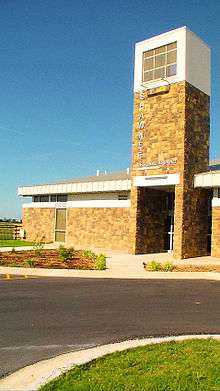 Main terminal | |||||||||||
| Summary | |||||||||||
| Airport type | Public | ||||||||||
| Owner | City of Shawnee | ||||||||||
| Serves | Shawnee, Oklahoma | ||||||||||
| Elevation AMSL | 1,073 ft / 327 m | ||||||||||
| Coordinates | 35°21′26″N 096°56′34″W | ||||||||||
| Website | ShawneeAirport.com | ||||||||||
| Map | |||||||||||
 SNL Location in Oklahoma | |||||||||||
| Runways | |||||||||||
| |||||||||||
| Statistics (2008) | |||||||||||
| |||||||||||
The National Plan of Integrated Airport Systems for 2011–2015 called it a general aviation facility.[4]
In 2011 the airport opened a new terminal building. The 4,000 sq ft (370 m2) building has a conference room and observation deck. The previous terminal was built in 1953.[5]
Facilities
Shawnee Regional Airport covers 520 acres (210 ha) at an elevation of 1,073 feet (327 m). Its one runway, 17/35, is 5,997 by 100 feet (1,828 x 30 m) asphalt.[1]
In the year ending August 29, 2008 the airport had 5,050 aircraft operations, average 13 per day: 99% general aviation and 1% military. 38 aircraft were then based at the airport: 84.2% single-engine, 10.5% multi-engine, 2.6% jet, and 2.6% helicopter.[1]
References
- FAA Airport Master Record for SNL (Form 5010 PDF). Federal Aviation Administration. Effective November 15, 2012.
- "IATA Airport Code Search (SNL: Shawnee Municipal)". International Air Transport Association. Retrieved December 16, 2012.
- "SNL – Shawnee Municipal Airport". FAA data republished by AirNav. March 22, 2001. Archived from the original on April 26, 2001.
- "2011–2015 NPIAS Report, Appendix A" (PDF, 2.03 MB). National Plan of Integrated Airport Systems. Federal Aviation Administration. October 4, 2010. External link in
|work=(help) - Kelley, Ann (July 28, 2011). "New terminal opens at Shawnee Regional Airport". The Oklahoman. Oklahoma City. Retrieved February 25, 2014.
External links
- Shawnee Regional Airport
- Shawnee Regional Airport (SNL) at Oklahoma Aeronautics Commission
- Aerial image as of February 1995 from USGS The National Map
- FAA Terminal Procedures for SNL, effective April 23, 2020
- Resources for this airport:
- FAA airport information for SNL
- AirNav airport information for KSNL
- ASN accident history for SNL
- FlightAware airport information and live flight tracker
- NOAA/NWS weather observations: current, past three days
- SkyVector aeronautical chart, Terminal Procedures