Oklahoma State Highway 270
State Highway 270, abbreviated as SH-270, is a 14.45-mile-long (23.26 km) state highway in Oklahoma and Pottawatomie counites in Oklahoma, United States. It runs on a former alignment of U.S. Route 270 (US-270) between US-62 in Harrah and US-177 north of Shawnee. (US-270 is now concurrent with Interstate 40 through the area.) SH-270 has no lettered spur routes.
| ||||
|---|---|---|---|---|
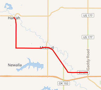
SH-270 highlighted in red | ||||
| Route information | ||||
| Maintained by ODOT | ||||
| Length | 14.45 mi[1][2] (23.26 km) | |||
| Existed | 1979[3] (March 5?[4])–present | |||
| Major junctions | ||||
| West end | ||||
| East end | ||||
| Location | ||||
| Counties | Oklahoma, Pottawatomie | |||
| Highway system | ||||
Oklahoma State Highway System
| ||||

Route description
State Highway 270 begins at US-62 in Harrah, in Oklahoma County. The road runs through town on a southeast course, paralleling a rail line. As it leaves town, the highway gradually curves to the south. SH-270 runs along Harrah Road to S.E. 29th Street, where it makes a hard left, turning to the east.[5]
SH-270 continues east for one mile (1.6 km) until it crosses into Pottawatomie County, where the name of the road changes to Oklahoma Street. SH-270 then enters McLoud, where it has a brief concurrency with SH-102. After leaving McLoud, it then turns back to the southeast, parallel to the same railroad it ran alongside in Harrah. SH-270 turns east upon reaching the small town of Dale. It then crosses over the railroad and the North Canadian River. After passing through Dale, it ends at US-177.[5]
History
Prior to 1979, US-270 ran through Oklahoma City on surface streets. It left the city and ran through Choctaw concurrent with US-62. US-270 split away from US-62 in Harrah, and continued on to Shawnee on what is now SH-270.[6]
On March 5, 1979, US-270 was rerouted to run concurrent with Interstate 40 from south of Calumet in Canadian County through the Oklahoma City metro, exiting the Interstate onto a surface alignment in Shawnee.[4] Presumably, SH-270 was commissioned the same date. The realignment of US-270, with SH-270 on the old alignment between Harrah and Shawnee, appears on the 1979 state map. SH-270 followed the same path in 1979 as it does today.[3]
Junction list
| County | Location | mi[7] | km | Destinations | Notes |
|---|---|---|---|---|---|
| Oklahoma | Harrah | 0.0 | 0.0 | Western terminus | |
| Pottawatomie | McLoud | 7.7 | 12.4 | Western end of SH-102 concurrency | |
| 7.9 | 12.7 | Eastern end of SH-102 concurrency | |||
| | 14.4 | 23.2 | Eastern terminus | ||
1.000 mi = 1.609 km; 1.000 km = 0.621 mi
| |||||
See also


References
- Oklahoma Department of Transportation (n.d.). Control Section Maps: Oklahoma County (PDF) (Map) (2010–2011 ed.). Scale not given. Oklahoma City: Oklahoma Department of Transportation. Retrieved May 3, 2013.
- Oklahoma Department of Transportation (n.d.). Control Section Maps: Pottawatomie County (PDF) (Map) (2010–2011 ed.). Scale not given. Oklahoma City: Oklahoma Department of Transportation. Retrieved May 3, 2013.
- Official State Map (PDF) (Map) (1979 ed.). Oklahoma Department of Transportation. Retrieved January 14, 2009.
- Oklahoma Department of Transportation, Planning & Research Division. "Memorial Dedication & Revision History - US-270". Retrieved January 14, 2009.
- Oklahoma Atlas and Gazetteer (Map). 1:200,000. DeLorme. 2006. p. 43.
- Official State Map (PDF) (Map) (1978 ed.). Oklahoma Department of Transportation. Retrieved January 14, 2009.
- Google (May 3, 2013). "Oklahoma State Highway 270" (Map). Google Maps. Google. Retrieved May 3, 2013.
External links
| Wikimedia Commons has media related to Oklahoma State Highway 270. |