Lincoln County, Oklahoma
Lincoln County is a county in eastern Central Oklahoma. As of the 2010 census, the population was 34,273.[2] Its county seat is Chandler.[3]
Lincoln County | |
|---|---|
_-_panoramio.jpg) | |
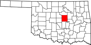 Location within the U.S. state of Oklahoma | |
 Oklahoma's location within the U.S. | |
| Coordinates: 35°42′N 96°53′W | |
| Country | |
| State | |
| Founded | 1891 |
| Named for | Abraham Lincoln[1] |
| Seat | Chandler |
| Largest city | Chandler |
| Area | |
| • Total | 966 sq mi (2,500 km2) |
| • Land | 952 sq mi (2,470 km2) |
| • Water | 13 sq mi (30 km2) 1.4%% |
| Population | |
| • Estimate (2018) | 34,920 |
| • Density | 35/sq mi (14/km2) |
| Time zone | UTC−6 (Central) |
| • Summer (DST) | UTC−5 (CDT) |
| Congressional district | 3rd |
Lincoln County is part of the Oklahoma City, OK Metropolitan Statistical Area.[4]
In 2010, the center of population of Oklahoma was in Lincoln County, near the town of Sparks.[5]
History
The United States purchased the large tract of land known as the Louisiana Purchase from France in 1803. Washington Irving, Charles J. Latrobe, and Count Albert de Pourtalès accompanied Henry L. Ellsworth and others on an expedition in Indian Territory that may have passed through the far northwestern corner of the future Lincoln County.[1]
The Osage hunted on land that includes present-day Lincoln County until they ceded the area in an 1825 treaty to the federal government. The government then assigned the land to the Creek and the Seminoles after they were removed from the southeastern United States. After the Civil War in 1866, these tribes were forced to give up lands that included present-day Lincoln County in Reconstruction Treaties for siding with the Confederacy.[1]
The federal government then used the area to resettle the Sac and Fox, Potawatomi, Kickapoo and Ioway tribes. Established in 1870, the Sac and Fox agency, established on the eastern edge of the present-day county, was the first settlement in the area.[1]
In 1890, the Jerome Commission negotiated with the tribes of the area such that they agreed to allotment of their reservation lands, except for the Kickapoo. Indian lands were allotted to individual tribal members and the excess were opened to white settlement in the Land Run of 1891. A separate land run was held later that year for the townsite of the predesignated county seat, Chandler. Lincoln County was organized and designated as County A. In 1895, the Kickapoo agreed to allotment and the land was claimed by settlers during the Land Run of 1895.[1]
The voters chose the name Lincoln County for County A in honor of President Abraham Lincoln, selecting it over the names Sac and Fox and Springer.[1]
Geography
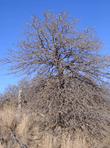
According to the U.S. Census Bureau, the county has an area of 966 square miles (2,500 km2), of which 952 square miles (2,470 km2) is land and 13 square miles (34 km2) (1.4%) is water.[6] The county is drained by the Deep Fork of the Canadian River. The eastern part of the county lies in the Cross Timbers and the Sandstone Hills, while the western part is in the Red Bed Plains.[1]
Major highways
.svg.png)


Adjacent counties
- Payne County (north)
- Creek County (northeast)
- Okfuskee County (southeast)
- Pottawatomie County (south)
- Oklahoma County (southwest)
- Logan County (northwest)
Demographics
| Historical population | |||
|---|---|---|---|
| Census | Pop. | %± | |
| 1900 | 27,007 | — | |
| 1910 | 34,779 | 28.8% | |
| 1920 | 33,406 | −3.9% | |
| 1930 | 33,738 | 1.0% | |
| 1940 | 29,529 | −12.5% | |
| 1950 | 22,102 | −25.2% | |
| 1960 | 18,783 | −15.0% | |
| 1970 | 19,482 | 3.7% | |
| 1980 | 26,601 | 36.5% | |
| 1990 | 29,216 | 9.8% | |
| 2000 | 32,080 | 9.8% | |
| 2010 | 34,273 | 6.8% | |
| Est. 2018 | 34,920 | [7] | 1.9% |
| U.S. Decennial Census[8] 1790-1960[9] 1900-1990[10] 1990-2000[11] 2010-2013[2] | |||
As of the census[12] of 2000, 32,080 people, 12,178 households, and 9,121 families resided in the county. The population density was 34 people per square mile (13/km²). There were 13,712 housing units at an average density of 14 per square mile (6/km²). The county's racial makeup was 86.43% White, 2.46% Black or African American, 6.57% Native American, 0.25% Asian, 0.02% Pacific Islander, 0.45% from other races, and 3.82% from two or more races. 1.51% of the population were Hispanic or Latino of any race.
There were 12,178 households out of which 34.10% had children under the age of 18 living with them, 61.50% were married couples living together, 9.20% had a female householder with no husband present, and 25.10% were non-families. 22.40% of all households were made up of individuals and 10.50% had someone living alone who was 65 years of age or older. The average household size was 2.59 and the average family size was 3.03.
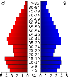
In the county, the population was spread out with 27.40% under the age of 18, 7.80% from 18 to 24, 26.70% from 25 to 44, 24.10% from 45 to 64, and 13.90% who were 65 years of age or older. The median age was 38 years. For every 100 females, there were 97.30 males. For every 100 females age 18 and over, there were 94.50 males.
The county's median household income was $31,187, and the median family income was $36,310. Males had a median income of $28,647 versus $20,099 for females. The county's per capita income was $14,890. About 11.10% of families and 14.50% of the population were below the poverty line, including 17.90% of those under age 18 and 12.10% of those age 65 or over.
Government and politics
| Voter Registration and Party Enrollment as of January 15, 2019[13] | |||||
|---|---|---|---|---|---|
| Party | Number of Voters | Percentage | |||
| Democratic | 5,933 | 30.61% | |||
| Republican | 10,735 | 55.38% | |||
| Unaffiliated | 2,716 | 14.01% | |||
| Total | 19,384 | 100% | |||
| Year | Republican | Democratic | Third parties |
|---|---|---|---|
| 2016 | 77.4% 10,854 | 17.3% 2,430 | 5.3% 741 |
| 2012 | 74.5% 9,553 | 25.5% 3,273 | |
| 2008 | 74.9% 10,470 | 25.1% 3,504 | |
| 2004 | 71.5% 10,149 | 28.5% 4,041 | |
| 2000 | 63.1% 7,387 | 35.4% 4,140 | 1.5% 174 |
| 1996 | 47.1% 5,243 | 39.0% 4,332 | 13.9% 1,547 |
| 1992 | 42.8% 5,315 | 31.4% 3,904 | 25.8% 3,204 |
| 1988 | 59.7% 6,409 | 39.3% 4,225 | 1.0% 106 |
| 1984 | 72.3% 8,088 | 27.0% 3,020 | 0.7% 81 |
| 1980 | 63.3% 6,064 | 33.7% 3,231 | 3.0% 290 |
| 1976 | 46.4% 4,429 | 52.2% 4,988 | 1.4% 133 |
| 1972 | 75.0% 6,512 | 22.1% 1,919 | 2.9% 254 |
| 1968 | 47.4% 3,855 | 28.4% 2,304 | 24.2% 1,969 |
| 1964 | 43.3% 3,854 | 56.7% 5,046 | |
| 1960 | 62.9% 5,528 | 37.1% 3,255 | |
| 1956 | 56.1% 4,993 | 43.9% 3,909 | |
| 1952 | 58.7% 5,778 | 41.3% 4,071 | |
| 1948 | 44.2% 3,898 | 55.8% 4,913 | |
| 1944 | 54.9% 4,801 | 44.7% 3,910 | 0.3% 28 |
| 1940 | 54.2% 6,269 | 45.5% 5,271 | 0.3% 34 |
| 1936 | 47.8% 5,452 | 51.8% 5,903 | 0.5% 52 |
| 1932 | 31.5% 3,505 | 68.6% 7,641 | |
| 1928 | 70.7% 6,118 | 27.8% 2,405 | 1.5% 126 |
| 1924 | 51.2% 4,220 | 39.8% 3,283 | 9.0% 739 |
| 1920 | 59.2% 5,261 | 33.6% 2,980 | 7.2% 640 |
| 1916 | 41.7% 2,387 | 39.4% 2,258 | 18.9% 1,081 |
| 1912 | 44.2% 2,459 | 38.4% 2,137 | 17.4% 969 |
United States Congress
| Senators | Name | Party | First Elected | Level | |
|---|---|---|---|---|---|
| Senate Class 1 | Jim Inhofe | Republican | 1994 | Senior Senator | |
| Senate Class 2 | James Lankford | Republican | 2014 | Junior Senator | |
| Representatives | Name | Party | First Elected | ||
| District 3 | Frank Lucas | Republican | 1994 | ||
Oklahoma Senate
| District | Name | Party | First Elected | Hometown | |
|---|---|---|---|---|---|
| 28 | Jason Smalley | Republican | 2014 | Stroud | |
Oklahoma House of Representatives
| District | Name | Party | First Elected | Hometown | |
|---|---|---|---|---|---|
| 32 | Kevin Wallace | Republican | 2014 | Wellston | |
Economy
The county economy has largely depended on agriculture. Cotton almost immediately became the dominant crop after white settlement. During the first decade of the twentieth century, Lincoln County was one of the top two counties producing cotton in Oklahoma. By the end of the Great Depression the economy had become more diversified. Oil furnished one-third of county tax revenue, and cattle raising and pecan growing became important income sources. By the turn of the 21st Century, the county economy had diversified and was based primarily on professional services, small businesses, and service industries.[1]
Communities
Unincorporated communities
- Arlington
- Jacktown
- Midlothian
- Parkland
- Rossville
Notable people
- Roy Harris (1898 - 1979), composer, born near Chandler;
- Carl Hubbell (1903 - 1988), U.S. major league baseball pitcher lived in Meeker;
- James Brooks Ayers Robertson (1871 - 1938), Oklahoma governor 1919-1923, lived and buried in Chandler;
- Jim Thorpe (1888 - 1953), American athlete, attended Sac and Fox agency school in Lincoln County.
- Roy J. Turner (1894 - 1973), Oklahoma governor 1947-1953, born in Kendrick.
NRHP sites
The following sites in Lincoln County are listed on the National Register of Historic Places:
|
|
References
- Mullins, William H. "Lincoln County - Encyclopedia of Oklahoma History and Culture". Oklahoma Historical Society. Retrieved 21 May 2011.
- "State & County QuickFacts". United States Census Bureau. Archived from the original on July 28, 2011. Retrieved November 9, 2013.
- "Find a County". National Association of Counties. Retrieved 2011-06-07.
- "County Profiles". www.greateroklahomacity.com. Retrieved 2018-03-29.
- "Centers of Population by State: 2010". United State Census Bureau. Retrieved February 21, 2015.
- "2010 Census Gazetteer Files". United States Census Bureau. August 22, 2012. Retrieved February 21, 2015.
- "Population and Housing Unit Estimates". Retrieved December 26, 2019.
- "U.S. Decennial Census". United States Census Bureau. Retrieved February 21, 2015.
- "Historical Census Browser". University of Virginia Library. Retrieved February 21, 2015.
- Forstall, Richard L., ed. (March 27, 1995). "Population of Counties by Decennial Census: 1900 to 1990". United States Census Bureau. Retrieved February 21, 2015.
- "Census 2000 PHC-T-4. Ranking Tables for Counties: 1990 and 2000" (PDF). United States Census Bureau. April 2, 2001. Retrieved February 21, 2015.
- "U.S. Census website". United States Census Bureau. Retrieved 2008-01-31.
- "Oklahoma Registration Statistics by County" (PDF). OK.gov. January 15, 2019. Retrieved 2019-02-27.
- Leip, David. "Dave Leip's Atlas of U.S. Presidential Elections". uselectionatlas.org. Retrieved 2018-03-29.
Places adjacent to Lincoln County, Oklahoma | |
|---|---|
Municipalities and communities of Lincoln County, Oklahoma, United States | ||
|---|---|---|
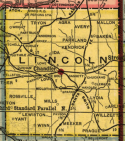
| Cities | Lincoln County map | |
| Towns | ||
| Unincorporated communities |
| |
| Ghost towns | ||
| Footnotes | ‡This populated place also has portions in an adjacent county or counties | |
Oklahoma City (capital) | ||
| Topics |
|  |
| Society |
| |
| Regions | ||
| Largest cities | ||
| Counties |
| |
| Authority control |
|
|---|