Port Douglas
Port Douglas is a coastal town and locality in the Shire of Douglas, Queensland,[2][3] approximately 70 km (40 mi) north of Cairns. In the 2016 census, Port Douglas had a population of 3,504 people.[1] The town's population can often double, however, with the influx of tourists during the peak tourism season from May to September. The town is named in honour of a former Premier of Queensland, John Douglas. Port Douglas developed quickly based on the mining industry. Other parts of the area were established with timber cutting occurring in the area surrounding the Daintree River and with settlement starting to occur on lots around the Mossman River by 1880.
| Port Douglas Queensland | |||||||||||||||
|---|---|---|---|---|---|---|---|---|---|---|---|---|---|---|---|
 Four Mile Beach | |||||||||||||||
 Port Douglas | |||||||||||||||
| Coordinates | 16.4834°S 145.4652°E | ||||||||||||||
| Population | 3,504 (2016 census)[1] | ||||||||||||||
| • Density | 194.7/km2 (504.2/sq mi) | ||||||||||||||
| Postcode(s) | 4877 | ||||||||||||||
| Elevation | 4 m (13 ft) | ||||||||||||||
| Area | 18.0 km2 (6.9 sq mi) | ||||||||||||||
| Time zone | AEST (UTC+10:00) | ||||||||||||||
| Location |
| ||||||||||||||
| LGA(s) | Shire of Douglas | ||||||||||||||
| County | Solander | ||||||||||||||
| State electorate(s) | Cook | ||||||||||||||
| Federal Division(s) | Leichhardt | ||||||||||||||
| |||||||||||||||
| |||||||||||||||
Previous names for the town included Terrigal, Island Point, Port Owen and Salisbury. The town is situated adjacent to two World Heritage areas, the Great Barrier Reef and the Daintree Rainforest.
Port Douglas was No. 3 on Australian Traveller magazine's list of 100 Best Towns In Australia.[4]
Government
The town is within the federal electorate of Leichhardt, and within the state electorate of Cook. At the local level, it is in the local government area of Shire of Douglas (between 2008 and 2013, it was within the Cairns Region).
History


The Port Douglas township was established in 1877 after the discovery of gold at Hodgkinson River by James Venture Mulligan. Port Douglas Post Office opened on 1 September 1877.[5] It grew quickly, and at its peak Port Douglas had a population of 12,000 and 27 hotels. With the construction of the Mulligan Highway it serviced towns as far away as Herberton.
Port Douglas State School opened on 11 November 1879, but closed in 1962. It was reopened on 23 January 1989.[6][7]
When the Kuranda Railway from Cairns to Kuranda was completed in 1891, the importance of Port Douglas dwindled along with its population. A cyclone in 1911 demolished or severely damaged all but seven residential buildings and 4 commercial buildings, including the Wharf buildings (rebuilt), the Courthouse (rebuilt), the Catholic church (rebuilt) and Chinese temple (not rebuilt).[8] At its nadir in 1960 the town, by then little more than a fishing village, had a population of 100.
The Port Douglas War Memorial was unveiled on 10 February 1923 by Mrs Tresize.[9]
In the late-1980s, tourism boomed in the region after investor Christopher Skase financed the construction of the Sheraton Mirage Port Douglas Resort.
Its permanent population was 3,205 at the time of the 2011 census.[10]
Heritage listings
Port Douglas has a number of heritage-listed sites, including:
- Macrossan Street: FDA Carstens Memorial[11]
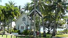
- Wharf Street: St Mary's by the Sea[12]
- 6 Dixie Street: Port Douglas Wharf[13]
- 25 Wharf Street: Port Douglas Court House Museum[14]
Population
In the 2016 Census, there were 3,504 people in Port Douglas. 56.6% of people were born in Australia. The next most common countries of birth were England 6.3% and New Zealand 5.9%. 76.6% of people spoke only English at home. The most common responses for religion were No Religion, so described 41.1% and Catholic 17.4%.[1]
Significant events, visitors and residents
On 5 July 1943, a RAAF Vultee Vengeance (Serial Number A27-217) crash landed on the beach near Port Douglas.[15]
In November 1996 United States President Bill Clinton and First Lady Hillary Clinton chose the town as their only holiday stop on their historic visit to Australia. When dining at a local restaurant they witnessed a couple's wedding certificate. On a return visit on 11 September 2001, Clinton was again dining at a local restaurant, when he was advised of the September 11 attacks. He returned to the United States the following day.[16]
On 4 September 2006, television personality and conservationist Steve Irwin died at Batt Reef, off Port Douglas, after a stingray barb pierced his heart during filming of a documentary called The Ocean's Deadliest.[17] Irwin was filmed snorkelling directly above the stingray when it lashed him with its tail, killing him almost immediately. The event was widely reported in Australia and overseas.[18]
The annual Port Douglas Carnivale is held in May and runs for 10 days over two weekends, beginning with a parade attracting over 10,000 people.[19] In October Porttoberfest (a play on Oktoberfest) is held. The Great Barrier Reef Marathon Festival is also held during October.[20]
Port Douglas was a popular location to view the 14 November 2012 solar eclipse that occurred at 6:38 am (local time). Thousands travelled to Port Douglas to see the phenomenon.
The music video for Kylie Minogue's 1988 single "It's No Secret" was filmed in Port Douglas.
Climate
Port Douglas has a tropical monsoon climate according to Köppen climate classification (Am), with hot summers and warm winters, with heavy rainfall primarily occurring from January–March, the wettest month of the year typically being February. The average temperature of the sea ranges from 23.7 °C (74.7 °F) in July to 29.5 °C (85.1 °F) in January.[21]
| Climate data for Port Douglas, Queensland | |||||||||||||
|---|---|---|---|---|---|---|---|---|---|---|---|---|---|
| Month | Jan | Feb | Mar | Apr | May | Jun | Jul | Aug | Sep | Oct | Nov | Dec | Year |
| Average high °C (°F) | 30.3 (86.5) |
30.1 (86.2) |
29.5 (85.1) |
28.3 (82.9) |
26.7 (80.1) |
25.1 (77.2) |
24.6 (76.3) |
25.3 (77.5) |
26.7 (80.1) |
28.3 (82.9) |
29.5 (85.1) |
30.3 (86.5) |
27.9 (82.2) |
| Average low °C (°F) | 23.7 (74.7) |
23.5 (74.3) |
22.8 (73.0) |
21.5 (70.7) |
19.5 (67.1) |
17.7 (63.9) |
16.8 (62.2) |
17.1 (62.8) |
18.6 (65.5) |
20.8 (69.4) |
22.3 (72.1) |
23.3 (73.9) |
20.6 (69.1) |
| Average precipitation mm (inches) | 401.6 (15.81) |
429.7 (16.92) |
425.6 (16.76) |
204.8 (8.06) |
70.8 (2.79) |
47.3 (1.86) |
25.6 (1.01) |
24.1 (0.95) |
32.0 (1.26) |
52.0 (2.05) |
107.9 (4.25) |
213.2 (8.39) |
2,032.4 (80.02) |
| Average precipitation days | 15.5 | 15.9 | 16.1 | 13.3 | 9.8 | 7.0 | 5.5 | 5.2 | 5.4 | 6.4 | 9.0 | 11.7 | 120.8 |
| Source: Bureau of Meteorology[22] | |||||||||||||
Recreation
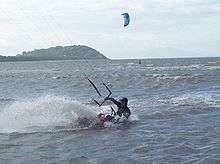
Kitesurfing is popular at the southern end of Four Mile Beach, particularly during the winter months when trade winds blow from the South.
Port Douglas is near the Great Barrier Reef. Numerous companies run daily trips from the marina to the outer reef and the Low Isles for scuba diving and snorkelling. Port Douglas is also well known for its many restaurants, walks, golf courses, and five star resorts.
The Port Douglas Community Hall houses the Port Douglas Library, 11–29 Mowbray Street, operated by the Douglas Shire Council.[23] The Library opened in 2010.[24] Another branch library is located in Mossman.[25]
The Port Douglas branch of the Queensland Country Women's Association meets at the CWA Hall at 8 Blake Street.[26]
Education
Port Douglas State School is a government primary (Prep-6) school for boys and girls at Endeavour Street (16.5242°S 145.4612°E).[27][28] In 2017, the school had an enrolment of 281 students with 20 teachers (17 full-time equivalent) and 12 non-teaching staff (8 full-time equivalent).[29]
For secondary school, Port Douglas is within the catchment of Mossman State High School.[30]
References
- Australian Bureau of Statistics (27 June 2017). "Port Douglas (SSC)". 2016 Census QuickStats. Retrieved 20 October 2018.

- "Port Douglas - town in Shire of Douglas (entry 27348)". Queensland Place Names. Queensland Government. Retrieved 26 November 2018.
- "Port Douglas - locality in Shire of Douglas (entry 48847)". Queensland Place Names. Queensland Government. Retrieved 26 November 2018.
- "100 Best Towns in Australia". "Archived copy". Archived from the original on 17 July 2013. Retrieved 21 July 2013.CS1 maint: archived copy as title (link) Retrieved 21 July 2013
- Premier Postal History. "Post Office List". Premier Postal Auctions. Retrieved 10 May 2014.
- "Opening and closing dates of Queensland Schools". Queensland Government. Retrieved 18 April 2019.
- Queensland Family History Society (2010), Queensland schools past and present (Version 1.01 ed.), Queensland Family History Society, ISBN 978-1-921171-26-0
- "A DEVASTATING CALAMITY". The Brisbane Courier (16, 597). Queensland, Australia. 22 March 1911. p. 5. Retrieved 14 April 2017 – via National Library of Australia.
- "Port Douglas War Memorial". Monument Australia. Archived from the original on 7 April 2014. Retrieved 4 April 2014.
- Australian Bureau of Statistics (31 October 2012). "Port Douglas". 2011 Census QuickStats. Retrieved 27 January 2014.
- "FDA Carstens Memorial (entry 601053)". Queensland Heritage Register. Queensland Heritage Council. Retrieved 7 July 2013.
- "St Mary's by the Sea (entry 600464)". Queensland Heritage Register. Queensland Heritage Council. Retrieved 7 July 2013.
- "Port Douglas Wharf and Storage Shed (former) (entry 600466)". Queensland Heritage Register. Queensland Heritage Council. Retrieved 7 July 2013.
- "Port Douglas Court House Museum (entry 600465)". Queensland Heritage Register. Queensland Heritage Council. Retrieved 7 July 2013.
- "5 July 1943: Crash of a Vultee Vengeance on a beach near Port Douglas, Qld". Australia @ War. 29 October 2018. Archived from the original on 28 September 2017. Retrieved 26 November 2018.
- KING, LARRY (3 September 2002). "Interview With Bill Clinton, Bob Dole, Andrew McKelvey, Dan Rather". Cable News Network. Archived from the original on 22 May 2011. Retrieved 15 November 2010.
- Jason Staines Crocodile man, Steve Irwin, dies Archived 19 October 2012 at the Wayback Machine, The Age, 4 September 2006
- Death footage 'will never see the light of day' Archived 8 April 2016 at the Wayback Machine, The Age, 7 September 2006
- Cotton, Martine. "Port Douglas Carnivale". Port Douglas Chamber of Commerce. Archived from the original on 20 February 2010. Retrieved 15 November 2010.
- Cullen, Sam. "Great Barrier Reef Marathon Festival". Port Douglas Event Management. Archived from the original on 5 July 2017. Retrieved 11 June 2017.
- "Archived copy". Archived from the original on 15 May 2018. Retrieved 7 June 2017.CS1 maint: archived copy as title (link)
- "Climate Statistics for Port Douglas, Queensland". 17 February 2012. Archived from the original on 27 February 2012.
- "Port Douglas, Directory of Public Libraries". Public Libraries Connect. 30 October 2017. Archived from the original on 1 February 2018. Retrieved 1 February 2018.
- "Queensland Public Libraries Statistical Bulletin 2016–2017" (PDF). Public Libraries Connect. November 2017. Archived (PDF) from the original on 30 January 2018. Retrieved 1 February 2018.
- "Douglas Shire, Public Libraries Connect". Public Libraries Connect. 20 September 2016. Archived from the original on 1 February 2018. Retrieved 1 February 2018.
- "Branch Locations". Queensland Country Women's Association. Archived from the original on 26 December 2018. Retrieved 26 December 2018.
- "State and non-state school details". Queensland Government. 9 July 2018. Archived from the original on 21 November 2018. Retrieved 21 November 2018.
- "Port Douglas State School". Archived from the original on 21 April 2013. Retrieved 21 November 2018.
- "ACARA School Profile 2017". Archived from the original on 22 November 2018. Retrieved 22 November 2018.
- "Queensland Globe". State of Queensland. Retrieved 26 November 2018.
External links
| Wikimedia Commons has media related to Port Douglas. |
| Wikivoyage has a travel guide for Port Douglas. |