Coen, Queensland
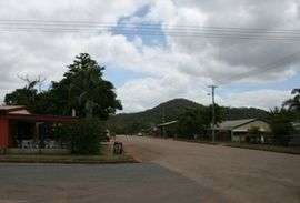
Coen is a town and coastal locality in the Shire of Cook, Queensland, Australia.[3][4] The town of Coen is inland on the Peninsula Developmental Road, the main road on the Cape York Peninsula in far northern Queensland. In the 2016 census, Coen had a population of 364 people.[1]
| Coen Queensland | |||||||||||||||
|---|---|---|---|---|---|---|---|---|---|---|---|---|---|---|---|
 | |||||||||||||||
 Coen | |||||||||||||||
| Coordinates | 13.9436°S 143.1986°E | ||||||||||||||
| Population | 364 (2016 census)[1] | ||||||||||||||
| • Density | 0.03739/km2 (0.09684/sq mi) | ||||||||||||||
| Postcode(s) | 4892 | ||||||||||||||
| Elevation | 199 m (653 ft)[2] | ||||||||||||||
| Area | 9,735.2 km2 (3,758.8 sq mi) | ||||||||||||||
| Time zone | AEST (UTC10) | ||||||||||||||
| Location | |||||||||||||||
| LGA(s) | Shire of Cook | ||||||||||||||
| State electorate(s) | Cook | ||||||||||||||
| Federal Division(s) | Leichhardt | ||||||||||||||
| |||||||||||||||
| |||||||||||||||
Geography
The locality of Coen is on the eastern side of Cape York Peninsula with the Coral Sea forming its eastern boundary. Part of the northern boundary follows the Archer River, while the Coen River forms part of its western boundary. The Peninsula Developmental Road runs roughly north to south through the locality.
History
Kaanju (also known as Kaanju and Kandju) is a language of Cape York. The Kaanju language region includes the landscape within the local government boundaries of the Cook Shire Council.[5]
In 1623, Jan Carstensz, the navigator of the ship Pera of the Dutch East India Company named a river on Cape York Peninsula after Jan Pieterszoon Coen, the Governor-General of the Dutch East Indies. Today that river is known as the Archer River and the name Coen River is given to one of its tributaries.[3][4]
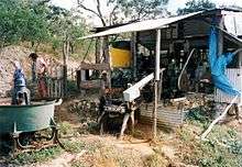
Gold was discovered on the Coen River in 1876. Coen came into being first as a small fort built by gold miners and prospectors in May 1877 but this first gold rush quickly came to an end, and the settlement did not recover until 1883. It became a centre for several small goldmines in the region but, in 1893, the rich Great Northern mine boomed and the town became a more substantial place.
Coen Post Office opened on 20 June 1893 (a receiving office had been open from 1888).[6]
The Great Northern mine continued operations until 1916 and produced some 52,000 troy ounces (1,617 kg) of gold before it closed.
On 3 July 2014, Barry Port retired from the Queensland Police. He was Australia's last Aboriginal police tracker. In his 36 years working for the police, he has tracked criminals, missing people and stowaways.[7][8]
In the 2011 census, Coen had a population of 416 people.[9]
Facilities
Today Coen provides services to the region, and is an important supply point on the long unpaved road leading to Weipa and other northern communities. It is a popular stopping point for tourists driving to the tip of Cape York - the northernmost part of the Australian mainland.
It has an airstrip at Coen Airport (24 kilometres (15 mi) north of the town), public library, hotel/motel, guest house, two general stores and fuel outlets, hospital, post office, police station, camping grounds, primary school kindergarten, ranger base and more. There is a scheduled air service to Lockhart and Cairns four times a week.
Attractions
Coen is an ideal destination for birdwatchers: there are good accommodations and a large and varied bird fauna with representatives from rain forest, monsoon forest and coastal forests.
Heritage listings
Coen has a number of heritage-listed sites, including:
- Coleman Close: Coen Carrier Station[10]
Footnotes
- Australian Bureau of Statistics (27 June 2017). "Coen (SSC)". 2016 Census QuickStats. Retrieved 20 October 2018.

- Bureau of Meteorology Archived 2 September 2007 at the Wayback Machine - Retrieved 2008-01-27
- "Coen (town) (entry 7669)". Queensland Place Names. Queensland Government. Retrieved 1 June 2014.
- "Coen (locality) (entry 46123)". Queensland Place Names. Queensland Government. Retrieved 1 June 2014.
-

- Premier Postal History. "Post Office List". Premier Postal Auctions. Retrieved 10 May 2014.
- McKillop, Charlie (3 July 2014). "Queensland's last Aboriginal police tracker calls it a day". Bush Telegraph. Australian Broadcasting Corporation. Archived from the original on 14 July 2014. Retrieved 3 July 2014.
- Fraser, Cleo (3 July 2014). "Australia's last police tracker retires". The Australian. Retrieved 3 July 2014.
- Australian Bureau of Statistics (31 October 2012). "Coen (SSC)". 2011 Census QuickStats. Retrieved 1 June 2014.
- "Coen Carrier Station (former) (entry 601485)". Queensland Heritage Register. Queensland Heritage Council. Retrieved 7 July 2013.
References
- Moon, Ron & Viv. 2003. Cape York: An Adventurer's Guide. 9th edition. Moon Adventure Publications, Pearcedale, Victoria. ISBN 0-9578766-4-5
- Roberts, Jan. 1981. Massacres to Mining: The Colonization of Aboriginal Australia. Dove Communications, Blackburn, Victoria. Rev. Australian ed. Previous ed.: CIMRA and War on Want, 1978, London. ISBN 0-85924-171-8.
- Premier's Department (prepared by Connell Wagner). 1989. Cape York Peninsula Resource Analysis. Cairns. (1989). ISBN 0-7242-7008-6
- Ryan, Michelle and Burwell, Colin, eds. 2000. Wildlife of Tropical North Queensland: Cooktown to Mackay. Queensland Museum, Brisbane. ISBN 0-85905-045-9 (set of 3 vols).
- Scarth-Johnson, Vera. 2000. National Treasures: Flowering plants of Cooktown and Northern Australia. Vera Scarth-Johnson Gallery Association, Cooktown. ISBN 0-646-39726-5 (pbk); ISBN 0-646-39725-7 Limited Edition - Leather Bound.
- Sutton, Peter (ed). Languages of Cape York: Papers presented to a Symposium organised by the Australian Institute of Aboriginal Studies. Australian Institute of Aboriginal Studies, Canberra. (1976). ISBN 0-85575-046-4
- Wallace, Lennie. 2003. Cape York Peninsula: A History of Unlauded Heroes 1845-2003. Central Queensland University Press, Rockhampton. ISBN 1-876780-43-6
- Wynter, Jo and Hill, John. 1991. Cape York Peninsula: Pathways to Community Economic Development. The Final Report of The Community Economic Development Projects Cook Shire. Cook Shire Council.
Further reading
| Wikimedia Commons has media related to Coen, Queensland. |
- McIvor, Roy (2010). Cockatoo: My Life in Cape York. Stories and Art. Roy McIvor. Magabala Books. Broome, Western Australia. ISBN 978-1-921248-22-1.
| Authority control |
|
|---|