Mapoon, Queensland
Mapoon is a coastal town in the Aboriginal Shire of Mapoon and a locality split between the Aboriginal Shire of Mapoon and the Shire of Cook in Queensland, Australia.[2][3][4]
| Mapoon Queensland | |||||||||||||||
|---|---|---|---|---|---|---|---|---|---|---|---|---|---|---|---|
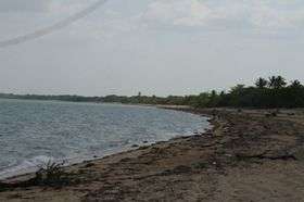 Mapoon beach | |||||||||||||||
 Mapoon | |||||||||||||||
| Coordinates | 12°01′S 141°54′E | ||||||||||||||
| Population | 317 (2016 census)[1] | ||||||||||||||
| • Density | 0.598/km2 (1.549/sq mi) | ||||||||||||||
| Postcode(s) | 4874 | ||||||||||||||
| Area | 530 km2 (204.6 sq mi) | ||||||||||||||
| LGA(s) | |||||||||||||||
| State electorate(s) | Cook | ||||||||||||||
| Federal Division(s) | Leichhardt | ||||||||||||||
| |||||||||||||||
Geography
Mapoon Aboriginal Community is located at Port Musgrave, western Cape York in Far North Queensland, Australia.
The community differs from many other Cape communities in that the quality government built residences are spread out in bushland along Red Beach Road towards Cullen Point rather than being clustered together.
During the wet season from December to April the area is largely inaccessible except by air and sea.[5]
History
Teppathiggi (also known Tepithiki and Teyepathiggi) is an Australian Aboriginal language of the Western Cape York, Middle Dulcie River, Lower Batavia River, Ducie River, and Mapoon. The language region includes areas within the local government boundaries of Cook Shire Council.[6]
Uradhi (also known as Anggamudi, Ankamuti, Atampaya, Bawtjathi, and Lotiga) is an Australian Aboriginal language of the Western Cape York Peninsula. The traditional language region includes north of Mapoon and Duyfken Point and east of the coast strip to the north of Port Musgrave (Angkamuthi country) incorporating the mouth of the Ducie River, the lower reaches of the Dulhunty River and the upper reaches of the Skardon River in the north. Following the displacement of Indigenous people by British settlement, it was also spoken in the Northern Peninsula Area Region including the communities of New Mapoon, Injinoo and Cowal Creek.[7]
A Presbyterian mission was established at Mapoon in 1891 with the aim of providing education and health services to the Aboriginal people. By 1907, under the Reformatories Act, it was operating as community for local people.
In the 1950s when bauxite was discovered on the Western Cape area, the Queensland Government passed legislation to help the interested companies Comalco and Alcan with the Comalco Act (Commonwealth Aluminium Corporation Pty Ltd Agreement Act 1957 (Qld)). As a consequence some 8,000 square kilometres were excised from the mission reserve.[8] The government, together with Comalco determined to evict the residents off the mission, and they were moved forcibly by the Queensland police from Old Mapoon to New Mapoon on 15 November 1963. The closing of the Mission was explained publicly as a measure to 'rationalise services' for the Cape indigenous people by centralising them in the Bamaga area. In November 1963, people were forced from their homes by armed police.[9] They were then transported 200 kilometres (120 mi) by ship.[10] The police raid was ordered and overseen by Patrick Killoran, the then director of Aboriginal Affairs in Queensland.[11]
Historical reports suggest that people were forced or tricked to board the barge. It was viewed by local people that the Aboriginal residents' houses were burnt to the ground to prevent the residents returning, however government reports state some houses were burnt due to their dangerous and verminous condition. Many residents were unhappy at Bamaga, at one of the nearby communities now known as New Mapoon. Over the following years, many moved back to (Old) Mapoon and eventually the government provided new housing.
The 1996 census population of Mapoon was 139.
In 2000, the Mapoon Aboriginal community was formally recognised under Deed of Grant in Trust arrangements. The Mapoon Aboriginal Council administers the community affairs with government support.
At the 2006 census, Mapoon had a population of 239.[12]
At the 2011 census the town recorded a population of 263 and 90% of the town's population was of Aboriginal or Torres Strait Islander descent.[13]
Facilities
Presently the town has a primary school, nursing station, council office and small shop providing fuel and food. Local people are employed on the Council which as well as providing services for the local community in 2006 won the contract to provide road maintenance for the all-weather 80 kilometres (50 mi) dirt road from the town of Weipa. There is also a productive fishing business, providing mudcrabs to southern markets from the Port Musgrave Bay and Dulhunty and Wenlock rivers.
Camping facilities near the town are found at Cullen Point and Janie Creek.[14] The area is known for excellent fishing and crabbing.
Education
Mapoon State School opened on 30 January 1995.[15] The school became Western Cape College - Mapoon on 1 January 2002.[15]
Alcohol Management Plan
An "Alcohol Management Plan" exists in the community, with restrictions on the amount and type of liquor that may be carried on persons or vehicles in the area.[16] This Plan was formulated and requested by the majority of Elders within the community and passed by law by the Government of Queensland into S.168 of the Liquor Act 1992. It is enforced by the Queensland Police based at Weipa.
Notes and references
References
Notes
- 2016 AU Census Australian Bureau of Statistics
- "Mapoon - town (entry 20875)". Queensland Place Names. Queensland Government. Retrieved 13 June 2017.
- "Mapoon - locality in the Aboriginal Shire of Mapoon (entry 45896)". Queensland Place Names. Queensland Government. Retrieved 13 June 2017.
- "Mapoon - locality in the Shire of Cook (entry 46135)". Queensland Place Names. Queensland Government. Retrieved 13 June 2017.
- "Mapoon - Department of Aboriginal and Torres Strait Islander Partnerships". Queensland Government - Department of Aboriginal and Torres Strait Islander Partnerships. Archived from the original on 25 January 2018. Retrieved 24 January 2018.
-

-
- Collings 1997.
- Bill Mason (17 November 1999). "Mapoon elder slams Lingard over 'straw hut' remarks". Green Left Weekly. Archived from the original on 9 April 2014. Retrieved 1 January 2013.
- Tony Koch (2 November 2010). "Notorious bureaucrat who oppressed Aborigines dies unlamented". The Australian. News Limited. Archived from the original on 4 February 2013. Retrieved 1 January 2013.
- "Emperor for Life: Killoran's Queensland". RadioNational. Australian Broadcasting Corporation. 10 June 2012. Archived from the original on 4 January 2013. Retrieved 1 January 2013.
- Australian Bureau of Statistics (25 October 2007). "Mapoon (Mapoon Shire) (State Suburb)". 2006 Census QuickStats. Retrieved 8 June 2011.
- Australian Bureau of Statistics (31 October 2012). "Mapoon". 2011 Census QuickStats. Retrieved 1 January 2013.

- "Mapoon". The State of Queensland. Archived from the original on 3 May 2012. Retrieved 1 January 2013.
- "Opening and closing dates of Queensland Schools". Queensland Government. Retrieved 18 April 2019.
- "Mapoon alcohol limits". Department of Aboriginal and Torres Strait Islander and Multicultural Affairs. 4 November 2012. Archived from the original on 30 April 2013. Retrieved 1 January 2013.
- Collings, Neva (1997). "The Wik: A History of Their 400 Year Struggle". Indigenous Law Bulletin. Australasian Legal Information Institute. 4 (1).CS1 maint: ref=harv (link)
External links
| Wikimedia Commons has media related to Mapoon, Queensland. |