Kowanyama, Queensland
Kowanyama is a town and coastal locality in the Aboriginal Shire of Kowanyama, Queensland, Australia.[2][3] In the 2016 census, Kowanyama had a population of 944 people.[4]
| Kowanyama Queensland | |
|---|---|
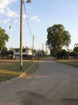 View down Ogimburngk St (from Gilbert St) | |
 Kowanyama | |
| Coordinates | 15°28′S 141°44′E |
| Population | 1,017 (2006 census)[1] |
| Postcode(s) | 4871 |
| LGA(s) | Aboriginal Shire of Kowanyama |
| State electorate(s) | Cook |
| Federal Division(s) | Leichhardt |
Geography
Kowanyama is a town on the Gulf of Carpentaria side of Cape York Peninsula.
The town resides within the Kowanyama Local Government Area (LGA) which covers a land area of 2,516.1 km².[5]
The aboriginal people who live in this community include Kokominjena, Kokoberra and Kunjen groups, amongst others. In their overarching Yir-Yoront language, Kowanyama means "The place of many waters."
The community is situated on the banks of the Magnificent Creek, a tributary of the Mitchell River, 20 kilometres (12 mi) inland from the coastline of the Gulf of Carpentaria.
Kowanyama is accessed by an all-weather airstrip, as well as unsealed roads in the dry season from Pormpuraaw to the north, Normanton to the south and Cairns to the east.
History
Kunjen (also known as Koko Wanggara, Ngundjan and Olkola) is a language of Western Cape York. The Kunjen language region includes the landscape within the local government boundaries of Kowanyama Community Council and Cook Shire Council.[6]
In 1905, Trubanamen Mission was established inland on Topsy Creek, now known as the old mission. Aboriginal peoples of the region were gradually drawn from their ancestral lands into the mission settlement.
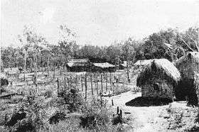
Later, in 1916, Mitchell River Mission was founded on the present site of Kowanyama and the Trubanamen site abandoned. Some peoples continued to occupy their traditional lands, moving into Kowanyama as late as the 1940s.
More than 1000 people now live in Kowanyama, making it one of the largest communities on the Cape York Peninsula. Kowanyama's Aboriginal people continue to identify strongly with their ancestral countries and with the languages, stories, songs, dances, and histories associated with those countries. Language groups associated with countries in the Kowanyama region are Yir Yoront, Yirrk Thangalkl, Koko Bera, Uw Oykangand, and Olkola.
In 1964, a cyclone destroyed the mission. The Queensland government funded the rebuilding.
Kowanyama Post Office opened by 1967.[7]
In 1967 the Anglican church were no longer able to sustain their activities in the area as a Church Mission. The Department of Aboriginal and Islander Affairs, a government department, under the Act continued running the affairs of the community.
In July 1987, the State Government of Queensland implemented legislation for a DOGIT over the lands in the Mitchell River delta, an area of 250 km². The deed covered the traditional lands of the people of Kowanyama. Like other DOGIT communities of the time, Kowanyama had a town Council elected by Aboriginal people living in the community. The newly formed Kowanyama Council assumed responsibility for implementing certain conditions of the DOGIT. Seven elected aboriginal residents hold three-year terms in office.
Since the 1990s, many Kowanyama people have been returning to their ancestral lands through the Homelands Movement. Homelands within the Kowanyama DOGIT include Scrubby Bore, Red Lilly, Ten Mile, Shelfo, Stewart Place, Old Rodeo Ground, Kowanyumal, Duck Hole, Wonya Bore, Kokomenjen Island, Wallaby Island, Joe's Lagoon, Yangr Bore, Engkoram, Fish Hole, Robert Demaine great elder and Thilpi.
Other homelands, including the Oriners Pastoral Lease and the Sefton Pastoral Lease, were independently purchased by the Kowanyama Council and are located outside the DOGIT boundary.
At the 2006 census, Kowanyama had a population of 1,017.[1]
In the 2016 census, Kowanyama had a population of 944 people.[4]
Shire Council operations
Community Justice Group
A Community Justice Group operates within Kowanyama. This group is made up of respected members in the community. They meet to discuss issues within the town and make recommendations to Council.
The community also has a Council of Elders, who are consulted by the Kowanyama Council when making community decisions. The elders operate in conjunction with the Lands Office.
The Lands Office
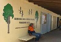
The Kowanyama Aboriginal Land and Natural Resources Management Office (KALNRMO) works to promote and facilitate aboriginal management of the natural and cultural resources of Kowanyama country by the people of Kowanyama. Through community consultation and direction, KALNRMO has developed a community development agenda for the Kowanyama region, including:
- Homelands development
- Land and Fisheries Management
- 'Tourism and Visitor management
- Kowanyama Ranger Service
- Native Title Claims
- Cultural Resource documentation
Through the initiatives of KALNRMO, the Kowanyama community is widely regarded as a leader in indigenous land management issues. Since 1987, Kowanyama has effected substantial local control over fishing in the Mitchell River Delta, including the closure of some waters to non-Aboriginal fishing under state fisheries legislation. This action, funded through the enterprise income of the Kowanyama Aboriginal Council, has provided Aboriginal people access to the River’s fish stocks for their cultural and economic needs. In this way, Aboriginal people can fish and hunt as they have done for many thousands of years.
KALNRMO employs a senior ranger and four field rangers. The Kowanyama Rangers implement land management strategies in many areas of the DOGIT, and, in addition to tourism and visitor management, patrol closed and open waters. The Rangers also observe fisheries regulations, especially for illegal commercial or recreational fishing in closed waters. Beginning in 2007, the Rangers monitor threatened turtle populations and participate in the Carpentaria Ghost Nets Programme to remove debris (primarily fishing nets) discarded into the Gulf of Carpentaria by commercial fishermen from Australia and Indonesia.
Education
The Kowanyama State School has approximately 210 students from pre-prep to year 10. Since the beginning of 2014, the school has also started to enrol students in a year 11 and 12 pathways program.[8]
The Kowanyama State School opened in January 1904.[9]
Shopping
Kowanyama has a small supermarket that sells fresh foods, packaged and frozen foods, and hardware items. The store is similar to a medium-sized IGA store. The store is operated by Department of Aboriginal and Torres Strait Islander Partnerships (DATSIP), and the manager is able to obtain any goods that are not normally kept for sale. The store prices are somewhat higher than provincial towns, which reflect the high costs of transport and storage.
The "Coffee Shop" does not sell coffee; operated by the Anglican Church, it stocks take away food, entertainment media and small goods.
Accommodation
Kowanyama River House is a 17-room guest house overlooking Magnificent Creek in Kowanyama Township. The guest house is located 100 metres from the Cultural Centre and 200 metres from the Kowanyama Aboriginal Shire Council offices and Supermarket.
Alcohol restrictions
Kowanyama community is subject to strict alcohol restrictions enforced by police prohibiting individuals holding any alcohol, and prohibiting any vehicles carrying alcohol anywhere within the community.[10]
Kowanyama Aboriginal Shire Council originally held a liquor licence allowing light beer to be consumed on the premises of the Kowanyama Canteen at specified times, but this was suspended by Queensland's Liquor Licensing Commission and Queensland Treasurer, Andrew Fraser, in February 2008.[11]
The decision to suspend Kowanyama Aboriginal Shire Council's liquor licence is claimed to have resulted in the Council losing a business valued at $1.6 million, plus up to $120,000 in stock.[12] As a consequence, on 30 October 2008, the Council went to Queensland's Supreme Court to challenge the liquor licensing decisions as racially discriminatory.[13]
Languages
Yir Yiront (also known as Yiront, Jirjoront, Yir-yiront, and Kokomindjan) is an Australian Aboriginal language. Its traditional language region is in Western Cape York within the local government areas of Aboriginal Shire of Kowanyama and Shire of Cook, in the catchments of the Coleman River and Mitchell River. Following the removal of Aboriginal people from their traditional lands, it is also spoken in Pormpuraaw and Kowanyama.[14]
Climate
Kowanyama experiences a tropical savanna climate (Köppen climate classification Aw). Daytime temperatures generally stay above 30 °C (86 °F) all year round and reach up to 35 °C (95 °F) in the pre-wet season period in October and November. The wet season runs from December to April and is characterized by frequent torrential downpours and high humidity. During the dry season, almost no rain falls and days are warm to hot but humidity is low and the nights can become quite mild.
In February 2014, 1,222.4 mm (48.13 in) of rain fell in Kowanyama over a six-day span, including a 24-hour total of 361.2 mm (14.22 in) on 8 February.[15] Residents were confined to their houses for almost two weeks; however no major damage was reported.[16]
| Climate data for Kowanyama | |||||||||||||
|---|---|---|---|---|---|---|---|---|---|---|---|---|---|
| Month | Jan | Feb | Mar | Apr | May | Jun | Jul | Aug | Sep | Oct | Nov | Dec | Year |
| Record high °C (°F) | 39.5 (103.1) |
38.5 (101.3) |
38.0 (100.4) |
36.7 (98.1) |
37.2 (99.0) |
36.7 (98.1) |
35.0 (95.0) |
37.5 (99.5) |
39.2 (102.6) |
41.0 (105.8) |
41.5 (106.7) |
41.0 (105.8) |
41.5 (106.7) |
| Average high °C (°F) | 33.0 (91.4) |
32.4 (90.3) |
32.8 (91.0) |
32.9 (91.2) |
32.0 (89.6) |
30.7 (87.3) |
30.7 (87.3) |
32.2 (90.0) |
34.6 (94.3) |
36.2 (97.2) |
36.2 (97.2) |
34.8 (94.6) |
33.2 (91.8) |
| Average low °C (°F) | 24.3 (75.7) |
24.2 (75.6) |
23.8 (74.8) |
21.8 (71.2) |
19.1 (66.4) |
16.1 (61.0) |
15.4 (59.7) |
16.1 (61.0) |
19.0 (66.2) |
21.9 (71.4) |
24.0 (75.2) |
24.3 (75.7) |
20.8 (69.4) |
| Record low °C (°F) | 17.2 (63.0) |
16.5 (61.7) |
13.3 (55.9) |
12.9 (55.2) |
8.5 (47.3) |
5.9 (42.6) |
5.9 (42.6) |
4.5 (40.1) |
9.0 (48.2) |
11.0 (51.8) |
13.7 (56.7) |
14.6 (58.3) |
4.5 (40.1) |
| Average rainfall mm (inches) | 341.0 (13.43) |
368.6 (14.51) |
237.1 (9.33) |
55.5 (2.19) |
11.0 (0.43) |
4.2 (0.17) |
2.4 (0.09) |
2.4 (0.09) |
2.6 (0.10) |
16.8 (0.66) |
57.5 (2.26) |
173.4 (6.83) |
1,272.5 (50.09) |
| Average rainy days (≥ 0.2 mm) | 17.2 | 17.4 | 14.2 | 4.9 | 1.3 | 0.8 | 0.6 | 0.4 | 0.4 | 1.5 | 4.6 | 11.2 | 74.5 |
| Source: Australian Bureau of Meteorology[17] | |||||||||||||
Travel
Kowanyama is serviced weekly in the dry season by road trains from Cairns. The service becomes more frequent as the wet season approaches.
Early storms in October can make the 400-kilometre (250 mi) dirt road to Chillagoe east of the community subject to flooding. By late December the storms of the monsoons have usually arrived, isolating the community by road.
The monsoons are regarded as the arrival of nhawrr yirrpa, the Rainbow Snake who brings the life giving water to the land. During the wet season, which may last until May, the community is serviced only by aircraft, as all other access is restricted. During the wet season, fresh foods and perishables are flown into the community each week on charter planes by stores in town. Airline passenger services to Cairns, 600 kilometres (370 mi) away is maintained throughout the year through Kowanyama Airport.
Further reading
- Moran, Mark 2006 PhD Chapter on Kowanyama reviewing Kowanyama's ethnographic materials and detailing Kowanyama's institutional structure, services, and local governance arrangements Accessed 25 January 2009
- Monaghan, James (2005) ‘Our Way': social space and the geography of land allocation practice on the southern Gulf Lowlands of Cape York Peninsula. PhD thesis, James Cook University.Accessed 26 January 2009
- Ethnologue.com entry for the Kunjun Language indigenous to the Kowanyama area Accessed 6 November 2008
- Queensland Government Department of Communities 'Descriptive Data on Cape York Communities including Kowanyama Accessed 6 November 2008
- Sharp, Nonie (1998) Reimagining Northern Seascapes in Australia: Open Access, Common Property and the Return of Responsibility? (Reference to Kowanyama on Pg 6) Accessed 6 November 2008
References
- Australian Bureau of Statistics (25 October 2007). "Kowanyama (Urban Centre/Locality)". 2006 Census QuickStats. Retrieved 5 July 2008.
- "Kowanyama - town in Aboriginal Shire of Kowanyama (entry 18529)". Queensland Place Names. Queensland Government. Retrieved 29 May 2019.
- "Kowanyama - locality in Aboriginal Shire of Kowanyama (entry 45504)". Queensland Place Names. Queensland Government. Retrieved 29 May 2019.
- Australian Bureau of Statistics (27 June 2017). "Kowanyama (SSC)". 2016 Census QuickStats. Retrieved 20 October 2018.

- "Kowanyama local government area". Department of Environment and Heritage Protection. Archived from the original on 25 October 2017. Retrieved 25 October 2017.
-

- Premier Postal History. "Post Office List". Premier Postal Auctions. Retrieved 10 May 2014.
- "Kowanyama SS". Archived from the original on 4 February 2017. Retrieved 31 January 2017.
- "Opening and closing dates of Queensland Schools". Queensland Government. Retrieved 18 April 2019.
- Queensland Government Liquor Licensing Division's Webpage on Kowanyama Archived 28 December 2008 at the Wayback Machine Accessed 20 November 2008
- National Indigenous Times 'Queensland's Kowanyama Canteen Looses Liquor Licence', 3 April 2008 Archived 6 July 2011 at the Wayback Machine Accessed 20 November 2008
- ABC News "Government Criticised over Prohibition by Stealth" 21 October 2008 Accessed 20 November 2008
- ABC News "Canteen Closures Not Racist: Bligh" 31 October 2008 Accessed 20 November 2008
-
- Kowanyama, Queensland February 2014 Daily Weather Observations (PDF). Bureau of Meteorology (Report). Government of Australia. 2014. Archived from the original (PDF) on 6 March 2014. Retrieved 6 March 2014.
- "QLD:Cyclone Fletcher to hit Monday". Australian Associated Press. 3 February 2014. – via Lexis Nexis (subscription required)
- "Climate statistics for Kowanyama". Australian Bureau of Meteorology. Archived from the original on 12 February 2014. Retrieved 22 March 2014.
External links
| Wikimedia Commons has media related to Kowanyama, Queensland. |
- "I belong student clip - Kowanyama" brief video on growing up in Kowanyama Accessed 25 January 2009
- Our World 2.0 Our World 2 Video & Video Brief on Saltwater vs Freshwater Changes around Kowanyama Accessed 21 January 2009
- Peta Hill 'Aboriginal Station Life' on-line photo collection of people and places around Kowanyama. Accessed 25 January 2009
- Story Place: Indigenous Art of Cape York web page on "Kowanyama" Accessed 9 November 2008
- Our World 2.0 United Nations University's 'Kowanyama Climate Change' video brief Accessed 19 November 2008
- World Wildlife Funds' News Archive 2001 Article on Kowanyama Cultural and Natural Resource Mapping Project Accessed 6 November 2008