Picketpost Mountain
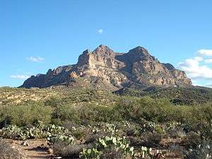
Picketpost Mountain is located just outside the town of Superior, Arizona approximately 40 miles (64 km) east of the Phoenix Metro Area. The mountain is located in the southern desert region of Tonto National Forest and is popular with hikers. The mountain is also well known for an oddly placed mailbox at the top of the mountain, which contains the log books for the Picketpost Mountain Trail.
| Picketpost Mountain | |
|---|---|
 Picketpost Mountain | |
| Highest point | |
| Elevation | 4,378 ft (1,334 m) NAVD 88[1] |
| Prominence | 1,455 ft (443 m) [2] |
| Coordinates | 33°15′24″N 111°09′28″W [1] |
| Geography | |
 Picketpost Mountain | |
| Location | Pinal County, Arizona, U.S. |
The mountain's unusual name stems from an early military camp established at the base of the mountain by General George Stoneman in 1870. The soldiers nicknamed the mountain “Picket Post” due to its usage as a sentinel point to guard their camp from attacks. This military camp eventually grew into the present day town of Superior.
References
- "Picket Post". NGS data sheet. U.S. National Geodetic Survey. Retrieved 2013-01-25.
- "Picketpost Mountain, Arizona". Peakbagger.com. Retrieved 2013-01-25.
External links
- "Picketpost Mountain". SummitPost.org.
This article is issued from Wikipedia. The text is licensed under Creative Commons - Attribution - Sharealike. Additional terms may apply for the media files.