Hualapai Peak
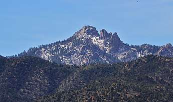
Hualapai Peak is a 8,417-foot (2,566 m) mountain summit in Mohave County, Arizona and is the highest point of the Hualapai Mountains.[1] It is located about 15 miles (24 km) southeast of Kingman in Hualapai Mountain County Park.
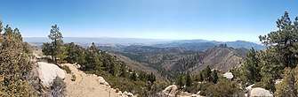
Picture taken of the surrounding landscape from near the summit of Hualapai Peak in Arizona.
| Hualapai Peak | |
|---|---|
 | |
| Highest point | |
| Elevation | 8,417 ft (2,566 m) [1] |
| Prominence | 4,439 ft (1,353 m) [1] |
| Isolation | 95.22 mi (153.24 km) [1] |
| Coordinates | 35°04′30″N 113°54′03″W [2] |
| Geography | |
 Hualapai Peak Location in the state of Arizona | |
| Location | Mohave County, Arizona, United States |
| Parent range | Hualapai Mountains |
The mountain is characterized by huge granite outcroppings and pillars, a result of its volcanic origin. Although trails lead to its base, a moderate scramble and climb is required to reach the summit.[3] There are also climbing routes along the trail to the peak.
It is named after the Hualapai Native American tribe. Hualapai means "people of the tall pines".[4]
See also
| Wikimedia Commons has media related to Hualapai Peak. |
| Wikimedia Commons has media related to Hualapai Mountains. |
References
- "Hualapai Peak, Arizona". Peakbagger. Retrieved 12 July 2017.
- U.S. Geological Survey Geographic Names Information System: Hualapai Peak
- "Hualapai Peak". SummitPost. 3 Sep 2014. Retrieved 12 July 2017.
- "About Hualapai « The Hualapai Tribe Website". hualapai-nsn.gov.
This article is issued from Wikipedia. The text is licensed under Creative Commons - Attribution - Sharealike. Additional terms may apply for the media files.