Dos Cabezas Mountains
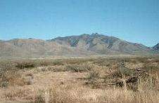
The Dos Cabezas Mountains are a mountain range in southeasternmost Arizona, USA. The 11,700 acres (4,700 ha) Dos Cabezas Mountains Wilderness lies 20 miles (32 km) east of Willcox and 7 miles (11 km) south of Bowie in Cochise County. The mountain range's name means Two Heads in Spanish, for the twin granite peaks, Dos Cabezas Peaks,[1] that sit atop the range.
| Dos Cabezas Mountains | |
|---|---|
 | |
| Highest point | |
| Peak | Dos Cabezas Peaks |
| Elevation | 8,354 ft (2,546 m) |
| Dimensions | |
| Length | 15 mi (24 km) NW x SE |
| Width | 6 mi (9.7 km) |
| Geography | |
| Country | United States |
| State | Arizona |
| Region | (northeast)-Sonoran Desert |
| Municipality | Bowie, Arizona (Willcox & Fort Bowie-W) |
| Range coordinates | 32°12′30″N 109°34′33″W |
| Borders on | Chiricahua Mountains-SE San Simon Valley-NE Sulphur Springs Valley-W & SW |
Geology

The wilderness consists of the rugged slopes of the Dos Cabezas Mountains, with elevations ranging from 4,080 to 7,500 feet (1,200 to 2,300 m). There is a diverse terrain of steep mountain slopes, granite outcroppings and vegetated canyon floors. The higher mountains and ridges offer long distance views of Sulphur Springs and San Simon Valleys and numerous mountain ranges.
Wildlife
Several developed and natural springs in the wilderness provide water for the abundant wildlife. White-tailed and mule deer, mountain lions, golden eagles, bald eagles and many other animals inhabit the Dos Cabezas Mountains. The collared lizard may be found in the upper portions of Buckeye Canyon. The peregrine falcon, a state and federally listed endangered species, migrates through the area. The majority of the wilderness contains mountain shrub, desert shrub and riparian vegetation. Arizona's Game and Fish department recently released photos from a 2016 sighting of the second known jaguar living in the state.[2]
See also
- Chiricahua Mountains – (connected at southeast)
External links
| Wikimedia Commons has media related to Dos Cabezas Mountains. |
- Bureau of Land Management
- Dos Cabezas Peaks, at Summitpost
- Dos Cabezas & Chiricahua Mtns, west of San Simon Valley; (Article)