Mount Trumbull Wilderness
The Mount Trumbull Wilderness is a 7,880 acre (31 km2) wilderness area located on the Uinkaret Plateau in the Arizona Strip. It is managed by the Bureau of Land Management.
| Mount Trumbull Wilderness | |
|---|---|
IUCN category Ib (wilderness area) | |
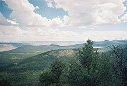
 A view of Mt. Trumbull from a nearby cinder cone | |
| Location | Mohave County, Arizona, United States |
| Nearest city | Fredonia, Arizona |
| Coordinates | 36°24′29″N 113°07′41″W |
| Area | 7,880 acre (31 km2) |
| Established | 1984 |
| Governing body | Bureau of Land Management |
The Mount Trumbull Wilderness is north of Grand Canyon National Park and in the Grand Canyon-Parashant National Monument. It is approximately 60 miles southwest of Fredonia, Arizona and about 60 miles south of St. George, Utah. It is about 7 miles north of the Mount Logan Wilderness.
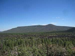
The namesake of the wilderness, Mt. Trumbull, is 8,028 feet (2,446m) at its highest point. A 2.5 mile trail to the top can be accessed from Mohave County Road 5. The mountain was named by John Wesley Powell after the Illinois Senator Lyman Trumbull.[1]
Flora
At lower elevations the vegetation of the wilderness consists of Utah juniper (Juniperus osteosperma), pinyon pine, Mojave yucca (Yucca schidigera), and sagebrush (Artemisia tridentata). Moving up, the vegetation slowly changes into towering ponderosa pines. There are also various types of grasses which grow intermittently throughout the wilderness.
Fauna
The wilderness is home to a variety of animals. Mule deer are a common sight in the mornings and late afternoons. There are a large number of squirrels including the Kaibab squirrel. Other more rare animals include pronghorn deer and mountain lions. There are also a variety of lizards in the area including horned lizards. Birds present include red crossbills, Steller's jays, common ravens and many others.
Archaeology
The wilderness contains both prehistoric and historic archaeological sites. The Anasazi are known to have inhabited the area, and an archaeological field school is conducted in and around the area each summer 1. In historic times the members of the Church of Jesus Christ of Latter-Day Saints used the area to harvest lumber to build many of the structures in St George, Utah.
See also
| Wikimedia Commons has media related to Mount Trumbull Wilderness. |
- Mount Logan Wilderness
- Wilderness
- Wilderness Act
- List of U.S. Wilderness Areas
- List of Arizona Wilderness Areas
References
- Powell, John Wesley. The Exploration of the Colorado River and its Canyons. 1961, Dover Publications, New York.