Little Dragoon Mountains
The Little Dragoon Mountains, are included in the Douglas Ranger District of Coronado National Forest, in Cochise County, Arizona.[1]
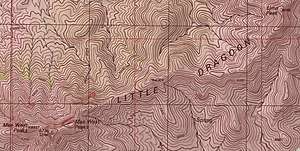
USGS topographic map of a portion of the ridgeline of the Little Dragoons
The summit of the range is the center peak of the three Mae West Peaks, 6 miles northwest of Dragoon, Arizona. The center peak, known as Lime has a peak elevation of 6,732 feet (2,052 m).[2] Lime Peak is a named peak along the ridgeline approximately 2.5 miles to the northeast which has a peak elevation of 6,658 feet (2,029 m).[3]
Interstate 10 passes through the Texas Canyon area approximately three miles to the southeast of the Little Dragoon ridgeline.[3]
See also
References
- "About Us". Coronado National Forest. U.S. Forest Service. 2008-08-24.
- "Lime". NGS data sheet. U.S. National Geodetic Survey. Retrieved 2014-02-05.
- Dragoon, AZ, 7.5 Minute Topographic Quadrangle, USGS, 1985
This article is issued from Wikipedia. The text is licensed under Creative Commons - Attribution - Sharealike. Additional terms may apply for the media files.