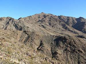
Mount Wilson (Arizona)
Mount Wilson is a mountain in Mohave County, Arizona, U.S. At 5,456 feet (1,663 m), it is the second highest point of the Black Mountains after Mount Perkins.[3]
| Mount Wilson | |
|---|---|
 Mount Wilson in December 2006 | |
| Highest point | |
| Elevation | 5,446 ft (1,660 m) NAVD 88[1] |
| Prominence | 3,205 ft (977 m) [2] |
| Coordinates | 35°59′48″N 114°36′43″W [1] |
| Geography | |
 Mount Wilson | |
| Location | Mohave County, Arizona, U.S. |
| Parent range | Black Mountains |
| Topo map | USGS Mount Wilson |
References
- "Mount Wilson". NGS data sheet. U.S. National Geodetic Survey. Retrieved 2016-08-21.
- "Mount Wilson, Arizona". Peakbagger.com. Retrieved 2015-01-01.
- "Black Mountains". Peakbagger.com. Retrieved 2016-08-21.
External links
- "Mount Wilson". Geographic Names Information System. United States Geological Survey.
- "Mount Wilson". SummitPost.org.

This article is issued from Wikipedia. The text is licensed under Creative Commons - Attribution - Sharealike. Additional terms may apply for the media files.