Baboquivari Peak Wilderness
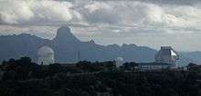
The Baboquivari Peak Wilderness is a 2,065-acre (8 km2) wilderness area in the U.S. state of Arizona. It is located in the Baboquivari Mountains 50 miles (80 km) southwest of Tucson, Arizona.[2] It is administered by the Bureau of Land Management. The United States Congress designated the Baboquivari Peak Wilderness in 1990. It is the smallest such designated wilderness in the state of Arizona. Today, the 2,900,000-acre (12,000 km2) Tohono O'odham Nation (second largest reservation in the United States) lies to the west. Baboquivari Peak's elevation is 7,730 feet (2,356 m). It is a popular site for many climbers, tourists and other visitors to Arizona and can be seen in the distance from the Kitt Peak National Observatory. The mountain was well known as a place to find flint for arrow points. BA BO QUAY VI RA, is translated as the place for the mother lode of flint. (America, Land of the Rising Sun—Don Smithana).
| Baboquivari Peak Wilderness | |
|---|---|
IUCN category Ib (wilderness area) | |
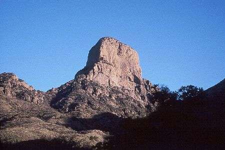 View of the east face of Baboquivari Peak | |
  | |
| Location | Pima County, Arizona, U.S. |
| Nearest city | Tucson, Arizona |
| Coordinates | 31.7914724°N 111.5756642°W[1] |
| Area | 2,065 acres (836 ha) |
| Designated | 1990 |
| Governing body | Bureau of Land Management |
Baboquivari Peak Wilderness is reported to have some of the best backcountry rock climbing in Arizona. It can be visited any time of the year; however, summer afternoons are usually too hot for hiking, and winter can bring an occasional snow shower to the peak's highest elevations. Sightings of jaguars have been recorded in the Baboquivaris during the last decades.[3]
Cultural significance

Baboquivari Peak is the most sacred place to the Tohono O'odham people. It is the center of the Tohono O'odham cosmology and the home of the creator, I'itoi. According to tribal legend, he resides in a cave below the base of the mountain.[4]
This mountain is regarded by the O'odham nation as the navel of the world — a place where the earth opened and the people emerged after the great flood. Baboquivari Peak is also sometimes referred to as I'Itoi Mountain. In the native O'odham language, it is referred to as Waw Kiwulik, meaning "narrow about the middle". The O'odham people believe that he watches over their people to this day.[4][5]
Baboquivari Peak was mentioned in the journals of Jesuit missionary Padre Kino, who made many expeditions into this region of the Sonoran Desert, beginning in 1699, establishing Spanish Missions in the area.[6][7]
Legend surrounding Baboquivari
According to O'odham nation legend at the beginning of the Spanish conquest of what is present day Arizona, a certain Spanish officer and his men tried to dig their way into Baboquivari. Suddenly, the ground under them opened and Baboquivari swallowed them. This legend has similarities to Francisco Vásquez de Coronado search for the Seven Cities of Cibola and a place called Quivira, where, he was told, he could get his hands on unlimited quantities of gold.[8]
Climbing History
Dr. R.H. Forbes and Sr. Montoya made the first recorded ascent of the peak on July 12, 1898. [9]
Natural features
There are a considerable number of topographic features within the Baboquivari Mountains, one of the most notable being Fresnal Canyon. Numerous flora and fauna species are found in the Baboquivari Peak Wilderness; among these is the desert tree Bursera fagaroides.[10]
See also
- List of Arizona Wilderness Areas
- Quivira and Cíbola
- Mission San Xavier del Bac
- 2059 Baboquivari
References
- "Baboquivari Peak Wilderness". Geographic Names Information System. United States Geological Survey. Retrieved June 23, 2012.
- "Baboquivari Peak Wilderness Area". Bureau of Land Management. Archived from the original on January 18, 2015. Retrieved January 17, 2015.
- Mccain, Emil B.; Childs, Jack L. (2008). "Evidence of resident jaguars (Panthera onca) in the Southwestern United States and the implications for conservation" (PDF). Journal of Mammalogy. 89 (1): 1–10. doi:10.1644/07-mamm-f-268.1. Archived from the original (PDF) on January 18, 2015. Retrieved January 17, 2015.
- "Baboquivari Mountain Petroglyphs, AZ (Tohono O'odham)". The Pluralism Project. 2004. Archived from the original on January 18, 2015. Retrieved January 17, 2015.
- "Kitt Peak National Observatory". National Optical Astronomy Observatory. Archived from the original on January 18, 2015. Retrieved January 17, 2015.
- "Baboquivari Peak Wilderness and Coyote Mountain Wilderness" (PDF). Bureau of Land Management. Archived (PDF) from the original on January 18, 2015. Retrieved January 17, 2015. Cite journal requires
|journal=(help) - Green, Stewart M. (1999). Rock Climbing Arizona. FalconGuides. p. 89. ISBN 9781560448136.
- Matlock, Gene (2000). India Once Rule the Americas!. iUniverse. p. 31. ISBN 9780595134687.
- Backcountry Rockclimbing in Southern Arizona, Second Edition (1997), at page 131, by Bob Kerry. ISBN 0-9641137-1-6. (353 pages)
- Hogan, C. Michael (October 11, 2009). "Elephant Tree Bursera microphylla". iGoTerra. Archived from the original on January 18, 2015. Retrieved January 17, 2015.
External links
| Authority control |
|
|---|