Otorohanga
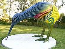
Otorohanga (Maori: Ōtorohanga) is a north King Country town in the Waikato region in the North Island of New Zealand. It is located 53 kilometres (33 mi) south of Hamilton and 18 kilometres (11 mi) north of Te Kuiti, on the Waipa River. It is a service town for the surrounding dairy-farming district. It is recognised as the "gateway" to the Waitomo Caves and as the "Kiwiana Town" of New Zealand. Until 2007, Otorohanga held a yearly 'Kiwiana Festival.'[2]
Otorohanga | |
|---|---|
 Otorohanga | |
| Coordinates: 38°11′S 175°12′E | |
| Country | |
| Region | Waikato |
| Territorial authority | Ōtorohanga District |
| Ward | Otorohanga |
| Electorate | Waikato |
| Government | |
| • Mayor | Max Baxter |
| Population (June 2019)[1] | |
| • Total | 2,890 |
| Time zone | UTC+12 (NZST) |
| • Summer (DST) | UTC+13 (NZDT) |
| Postcode(s) | 3900 |
| Area code(s) | 07 |
History

Early history
In the 1860s Otorohanga was a Ngāti Maniopoto village, with whares, peach trees and a flour mill. It was abandoned after the invasion of the Waikato, except for Lewis Hettit's (or Hetet)[3] farm.[4] The area remained insecure, with Hettit's store being robbed by Te Kooti[5] in 1869,[6] but a meeting with Donald McLean later that year signalled moves towards peace.[7]
John William Ellis became postmaster and opened a store in 1885[8] with Henry Valder[9] and John Taonui Hetet.[10] In 1886 Ngāti Maniopoto built a court room for the Native Land Court[11] and from that year mail was delivered 3 times a month[12] and disputes which had delayed development[13] were settled.[14] On 9 March 1887 the railway was extended 14 mi (23 km) from Te Awamutu[15] and a 14-room[16] hotel was built, primarily for those attending the Court.[17] The sawmill, later run by Ellis and Burnand, started in 1890[18] and closed in 1912.[19]
Modern history
In the early 1900s many businesses were established by Māori, in particular John Ormsby (Hōne Ōmipi).[20] The Otorohanga Times was formed in 1912; it merged with the King Country Chronicle to form the Waitomo News in 1980.[21] McDonald’s began a limestone quarry south of Otorohanga in 1968,[22] which was bought by Graymont in 2015.[23]
Otorohanga’s population grew from 367 in 1916 to 1,569 in 1951, after which growth slowed. Although population dropped from 2,652 in 1991 and to 2,514 in 2013, the fall was much less than in the rest of King Country.[20]
Harrodsville
In 1986, the town briefly changed its name to "Harrodsville". This was a protest in support of a restaurateur, Henry Harrod of Palmerston North, who was being forced to change the name of his restaurant following the threat of lawsuits from Mohamed Al Fayed, the then owner of Harrod's department store in London.[24][25]
As a show of solidarity for Henry Harrod, and in anticipation of actions against other similar-sounding businesses, it was proposed that every business in Otorohanga change its name to "Harrods". With the support of the District Council, Otorohanga temporarily changed the town's name to Harrodsville.
After being lampooned in the British tabloids, Al Fayed dropped the legal action and Harrodsville and its shops reverted to their former names. The town's response raised widespread media interest around the world, with the BBC World Service and newspapers in Greece, Saudi Arabia, Australia and Canada covering the story.
Local government
Otorohanga is part of the Otorohanga District, which stretches from Kawhia Harbour on the west coast inland to the Pureora Forest Park. The town is the largest in the District and the seat of the District Council.
Marae
Six marae are located in and around Otorohanga:
- Kahotea Marae and Whatihua meeting house is a meeting place for the Maniapoto hapū of Apakura, Hinetū, Matakore and Pare te Kawa, and the Waikato Tainui hapū of Apakura.
- Rereamanu Marae and Te Kawau Kaki Maro meeting house is a meeting place for the Maniapoto hapū of Huiao and Te Kanawa.
- Tārewānga Marae and Te Rau a te Moa meeting house is a meeting place for the Maniapoto hapū of Pare te Kawa, Rungaterangi, Urunumia and Tārewānga.
- Te Keeti Marae and Parewaeono meeting house is a meeting place of the Maniapoto hapū of Ngutu, Parewaeono and Urunumia.
- Te Kotahitanga Marae and Te Kotahitanga meeting house is a meeting place for the Maniapoto hapū of Pourahi and Urunumia.
- Turitea Marae and Turitea meeting house is a meeting place for the Maniapoto hapū of Pourahui.[26][27]
Attractions
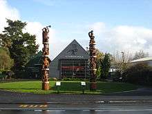
Otorohanga is internationally renowned for its Kiwi House,[28] which was the first place in the world where the general public could view kiwi in captivity,[29] and recorded an average of 5,000 visitors per month in 2008.[30] The town has a public library, a swimming complex, a supermarket and a 24-hour McDonald's restaurant.
Transport
Otorohanga is on the North Island Main Trunk railway line. Otorohanga railway station opened in 1887. The Northern Explorer passenger train stops in Otorohanga.[31]
Education
Otorohanga School is a Year 1–8 co-educational state primary school.[32] It is a decile 2 school with a roll of 48 as of March 2020.[33][34]
Otorohanga South School is a Year 1–8 co-educational state primary school.[35] It is a decile 4 school with a roll of 318 as of March 2020.[33][36]
St Mary's Catholic School is a Year 1–8 co-educational state integrated Catholic primary school.[37] It is a decile 5 school with a roll of 42 as of March 2020.[33][38]
Otorohanga College is a Year 9–13 co-educational state secondary school and community education centre.[39][40] It is a decile 4 school with a roll of 301 as of March 2020.[33][41]
References
- "Subnational Population Estimates: At 30 June 2019". Statistics New Zealand. 22 October 2019. Retrieved 11 January 2020.
- "Kiwiana Town – for all things "Kiwiana"". Kiwianatown.co.nz. Retrieved 10 July 2015.
- "Presentation to Mr and Mrs J. T. Hetet". Waikato Times. 14 April 1906. p. 3. Retrieved 23 March 2018.
- "Sketches in the King Country". New Zealand Herald. 26 May 1883. p. 1. Retrieved 23 March 2018.
- "Chapter xvi. — Colonel Whitmore". nzetc.victoria.ac.nz. Retrieved 23 March 2018.
- "Hettit's Store Plundered by Te Kooti. [from the Southern Cross, July 22.]". Nelson Examiner and New Zealand Chronicle. 28 July 1869. p. 4. Retrieved 23 March 2018.
- "Waikato". Hawke's Bay Herald. 19 November 1869. p. 3. Retrieved 24 March 2018.
- Cleaver, Philip (February 2011). "Maori and the Forestry, Mining, Fishing, and Tourism Industries of the Rohe Potae Inquiry District 1880-2000" (PDF). Waitangi Tribunal.
- "Otorohanga's Past". Auckland Star. 12 March 1926. p. 12. Retrieved 16 February 2018.
- "Presentation to Mr and Mrs J. T. Hetet". Waikato Times. 14 April 1906. p. 3. Retrieved 16 February 2018.
- James Stuart Mitchell, Paul Husbands (November 2011). "The Native Land Court, land titles and Crown land purchasing in the Rohe Potae district, 1866-1907 A report for the Te Rohe Potae district inquiry (Wai 898)" (PDF). Waitangi Tribunal.
- "Page 3 Advertisements Column 5". Auckland Star. 17 September 1886. p. 3. Retrieved 23 March 2018.
- "Another Native Difficulty. Te Wetere Stops the Way. Affairs at Otorohanga". Waikato Times. 29 July 1886. p. 2. Retrieved 23 March 2018.
- "Tee King Country". New Zealand Herald. 2 August 1886. p. 6. Retrieved 23 March 2018.
- "Waikato Times". 8 March 1887. p. 2. Retrieved 23 March 2018.
- "Waikato District News". New Zealand Herald. 28 April 1887. p. 6. Retrieved 23 March 2018.
- "Page 3 Advertisements Column 5". Waikato Times. 17 September 1887. p. 3. Retrieved 23 March 2018.
- "Country News". New Zealand Herald. 3 October 1890. p. 6. Retrieved 16 February 2018.
- "1953 jubilee year: half a century of progress in the timber industry of New Zealand, 1903-1953. | National Library of New Zealand". natlib.govt.nz. Mccracken, A.E. Retrieved 22 May 2018.CS1 maint: others (link)
- Taonga, New Zealand Ministry for Culture and Heritage Te Manatu. "2. – King Country places – Te Ara Encyclopedia of New Zealand". teara.govt.nz. Retrieved 23 March 2018.
- Taonga, New Zealand Ministry for Culture and Heritage Te Manatu. "Otorohanga Times, around 1912". teara.govt.nz. Retrieved 23 March 2018.
- Cleaver, Philip (February 2011). "Maori and the Forestry, Mining, Fishing, and Tourism Industries of the Rohe Potae Inquiry District 1880-2000" (PDF). Waitangi Tribunal.
- "Graymont || About Us". www.onlime.co.nz. Retrieved 24 March 2018.
- "Chatological Humor (Updated 11.16.07)". Washingtonpost.com. Retrieved 10 July 2015.
- "New Zealand: Small Town Shops Face Legal Action from Harrods Lawyers in London". Itnsource.com. Retrieved 10 July 2015.
- "Te Kāhui Māngai directory". tkm.govt.nz. Te Puni Kōkiri.
- "Māori Maps". maorimaps.com. Te Potiki National Trust.
- Otorohanga Zoological Society Inc. "Best place to see kiwi - Otorohanga, New Zealand". Kiwihouse.org.nz. Retrieved 10 July 2015.
- Otorohanga Zoological Society Inc. "First New Zealand Kiwi House Otorohanga NZ". Kiwihouse.org.nz. Retrieved 10 July 2015.
- "Kiwi House Review : No. 42" (PDF). Kiwihouse.org.nz. Archived from the original (PDF) on 11 March 2012. Retrieved 10 July 2015.
- Northern Explorer. The Great Journeys of New Zealand. KiwiRail. Retrieved 21 July 2019.
- "Ministry of Education School Profile". educationcounts.govt.nz. Ministry of Education.
- "New Zealand Schools Directory". New Zealand Ministry of Education. Retrieved 26 April 2020.
- "Education Review Office Report". ero.govt.nz. Education Review Office.
- "Ministry of Education School Profile". educationcounts.govt.nz. Ministry of Education.
- "Education Review Office Report". ero.govt.nz. Education Review Office.
- "Ministry of Education School Profile". educationcounts.govt.nz. Ministry of Education.
- "Education Review Office Report". ero.govt.nz. Education Review Office.
- "Official School Website". otocoll.school.nz.
- "Ministry of Education School Profile". educationcounts.govt.nz. Ministry of Education.
- "Education Review Office Report". ero.govt.nz. Education Review Office.