Te Awamutu
Te Awamutu is a town in the Waikato region in the North Island of New Zealand. It is the council seat of the Waipa District and serves as a service town for the farming communities which surround it. Te Awamutu is located some 30 kilometres (19 mi) south of Hamilton on State Highway 3, one of the two main routes south from Auckland and Hamilton.
Te Awamutu | |
|---|---|
Town | |
| Nickname(s): T.A., "The Rose Town of New Zealand" | |
 Te Awamutu Location of Te Awamutu | |
| Coordinates: 38°01′S 175°19′E | |
| Country | New Zealand |
| Region | Waikato |
| Territorial authority | Waipa District |
| Government | |
| • Mayor | Jim Mylchreest |
| Population (2013 Census)[1] | |
| • Total | 10,305 |
| Time zone | UTC+12 (NZST) |
| • Summer (DST) | UTC+13 (NZDT) |
| Website | City: teawamutu.co.nz Region: http://www.ew.govt.nz |
The town is often referred to as "The Rose Town of New Zealand" because of its elaborate rose gardens in the centre of the town.[2] Many local businesses use "Rosetown" in their name, and the symbol of the rose is widely used on local signs and billboards. The local paper, Te Awamutu Courier, has a symbol of a rose in the masthead on its front page.
History and culture

Tainui Maori first settled in the area in about 1450, according to noted Tainui historian Te Hurinui-Jones. Te Awamutu means "the river cut short", as it marked the end of the navigable section of the Mangapiko Stream.[3]
Te Awamutu was the birthplace of the first Maori King, Pōtatau Te Wherowhero (died 1860).
The first European missionaries visited the area in 1834. A missionary settlement was set up by Benjamin Yate Ashwell of the Church Missionary Society (CMS).[4][5][6] and Māori Christians in July 1839 after they observed Tainui warriors, who had been fighting at Rotorua, return with 60 backpacks of human remains and proceed to cook and eat them in the Otawhao Pa.[7] In 1842 the Rev. John Morgan moved to the Otawhao Mission Station.[8]
The CMS missionaries established a flourishing trade school that focused on developing agricultural skills. The missionaries introduced European crops such as wheat, potatoes and peaches. In 1846 Morgan provided advice and some capital to help local Māori to construct eight water mills to grind wheat into flour.[9] Morgan assisted in finding a suitable miller to operate the mills and to train Maori in this skill.[10]
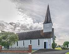
The oldest surviving building in the Waikato is St John's church, built in 1853 as part of the mission station. It is in Gothic Revival style.[11]
| Te Awamutu | |
|---|---|
| Designated | 28 June 1984 |
| Reference no. | 28 |
During the 1850s the wider area prospered on the back of sending surplus farm produce to Auckland. For a brief period wheat was even sent overseas. By the late 1850s prices dropped as cheaper flour and other foodstuffs were imported from Australia. This caused huge resentment among local Māori who had grown use to the wealth provided by trade. Some of the more warlike Māori such as Rewi Maniapoto blamed the missionaries for having a negative influence on Māori tikanga (cultural practices). He attempted to kill the local missionary and burnt down the trade school and other mission buildings. Some Christian Māori warned Europeans to leave the Waikato as their lives were in danger. Te Awamutu was a major site during the New Zealand Wars of the 19th century, serving as a garrison town for the colonial settlers from 1864. European settlement began at the conclusion of the Waikato Wars (1863–1865).[12]
The local Mangatoatoa Marae and Te Maru o Ihowa meeting house is a meeting place for the Maniapoto hapū of Ngutu, Pare te Kawa and Parewaeono, and the Waikato Tainui hapū of Ngāti Ngutu and Ngāti Paretekawa.[13][14]
Geography
Te Awamutu literally means in English "The River's End".[15] The town is on gently undulating land close to the banks of a tributary of the Waipa River. The Waikato Plains lie to the north and east, and the promontory of Mount Pirongia, 20 kilometres to the west, is easily visible. Inside the township are two streams called the Mangapiko Stream and the Mangaohoi Stream. The Mangaohoi ends and becomes the Tributary of the Mangapiko near Memorial park.
The town is close to the extinct Kakepuku and Pirongia volcanoes (and other volcanoes of the Alexandra Volcanic Group). Maungatautari, another extinct volcanic cone, now the site of New Zealand's largest ecological restoration project, is also nearby.
Other towns surrounding Te Awamutu include Cambridge, 25 kilometres to the northeast, Otorohanga, 30 kilometres to the southwest, and Raglan 50 kilometres to the northwest. The small town of Kihikihi lies just to the south of Te Awamutu.
The main thoroughfare is Alexandra Street, so named because it was once the main road to the town of Alexandra (since renamed to Pirongia to avoid confusion with the town of Alexandra in the South Island).
Demographics
It has a population of 10,305[1] but with Kihikihi and surrounding rural areas a total population of about 14,000 can be claimed.
For the census Te Awamutu is divided into four area units, central, east, south and west, as in this table.[16] Māori formed 19.7% of the population in central, 22.8% in east, 23.2% in south and 25.7% in west.[17]
| Year | Population | Households | Median age | Median income | National median | |
| Te Awamutu total | 2001 | 9,180 | 3,531 | $18,500 | ||
| 2006 | 9,819 | 3,828 | $24,400 | |||
| 2013 | 10,308 | 4,125 | $28,500 | |||
| Central | 2001 | 2,892 | 1,179 | 40.5 | $16,900 | |
| 2006 | 3,153 | 1,281 | 42.1 | $21,800 | ||
| 2013 | 3,321 | 1,368 | 41.6 | $26,700 | ||
| East | 2001 | 2,301 | 849 | 34.9 | $17,200 | |
| 2006 | 2,511 | 975 | 38.9 | $23,500 | ||
| 2013 | 2,769 | 1,107 | 42.0 | $27,400 | ||
| South | 2001 | 2,862 | 1,098 | 38.7 | $16,800 | |
| 2006 | 2,928 | 1,131 | 39.8 | $21,300 | ||
| 2013 | 2,913 | 1,176 | 41.8 | $25,100 | ||
| West | 2001 | 1,125 | 405 | 33.6 | $18,100 | |
| 2006 | 1,227 | 441 | 35.4 | $25,400 | ||
| 2013 | 1,305 | 474 | 36.4 | $28,500 |
Facilities and attractions
Te Awamutu Museum was established in 1935. The museum has a number of permanent exhibitions focusing on the history of Te Awamutu and the surrounding area.[18] There is also an exhibition, 'Everyone is here' focusing on Tim and Neil Finn, brothers and Te Awamutu natives, of the bands Split Enz and later Crowded House.
The museum contains one of the most famous early Māori artifacts, a large carved post known simply as Te Uenuku. This impressive carving has caused much controversy because its style is markedly different from any other early Māori work, yet it is clearly of a Māori design.
Te Awamutu itself is located on SH3, one of the major routes used when touring the North Island of New Zealand.
The town has three large supermarkets, electronics retailers, a well equipped sports / leisure centre and The Kihikihi Trail cycleway,[19] which opened in 2017.[20]
The town has a large dairy factory, and serves as an important centre in the local dairy industry.
Education
Te Awamutu has two co-educational state primary schools: Te Awamutu Primary School, with a roll of 489[21][22] and Pekerau School with a roll of 201.[23][24]
Many of these students then progress on to Te Awamutu Intermediate, with a roll of 489,[25][26] and Te Awamutu College, with a roll of 1289.[27][28]
There are also three other schools in the town:
- St Patrick's Catholic School is a co-educational Year 1-8 state integrated Catholic primary school,[29] with a roll of 251.[30]
- Waipa Christian School is a co-educational Year 1-8 state integrated Christian primary school,[31] with a roll of 76.[32]
- Te Wharekura o Nga Purapura o te Aroha is a co-educational Year 1-15 state school,[33] with a roll of 105 as of March 2020[34]
Notable residents
The town's best known residents are the Finn Brothers, Tim and Neil, whose musical careers have stretched from Split Enz through the internationally successful Crowded House to their current solo and collaborative works. The town is mentioned in Split Enz's song "Haul Away", and also in Crowded House's 1986 song "Mean to Me", the debut single from their self-titled debut album. Musician Spencer P. Jones (The Beasts of Bourbon, Paul Kelly and The Coloured Girls) was also born in Te Awamutu. Filmmaker and Bilbo double in Peter Jackson's The Hobbit series Hayden J. Weal was also born and raised here.[35]
See also
- Te Awamutu Railway Station
References
- The population is the aggregation of the Census figures for Te Awamutu West (2013 Census QuickStats about a place : Te Awamutu West), Te Awamutu Central (2013 Census QuickStats about a place : Te Awamutu Central), Te Awamutu East (2013 Census QuickStats about a place : Te Awamutu East) and Te Awamutu South (2013 Census QuickStats about a place : Te Awamutu South).
- "New Zealand North Island Things To See And Do". Retrieved 7 January 2011.
- "Te Awamutu". An Encyclopaedia of New Zealand. 1966.
- Rogers, Lawrence M. (1973). Te Wiremu: A Biography of Henry Williams. Pegasus Press.
- "The Church Missionary Atlas (Church Missionary Society)". Adam Matthew Digital. 1896. pp. 210–219. Retrieved 19 October 2015.
- Bernard John Foster; edited by A. H. McLintock (1966). "'ASHWELL, Benjamin Yates'". Dictionary of New Zealand Biography. Te Ara: The Encyclopedia of New Zealand. Retrieved 29 January 2019.
- A Lone Hand in Cannibal Land James Cowan The New Zealand Railways Magazine, Volume 9, Issue 6 (1 September 1934) NZETC
- "The Church Missionary Gleaner, December 1846". The Station of Otawao, New Zealand. Adam Matthew Digital. Retrieved 16 October 2015.
- "The Church Missionary Gleaner, August 1847". Advancement of New Zealanders in Civilization. Adam Matthew Digitals. Retrieved 16 October 2015.
- Petrie, Hazel (2006). Chiefs of Industry: Maori Tribal Enterprise in Early Colonial New Zealand. Auckland University Press. ISBN 9781869403768.
- "St John's Church (Anglican)". www.heritage.org.nz. Retrieved 15 March 2020.
- Keenan, Danny. "Story: New Zealand wars". The Encyclopedia of New Zealand. Retrieved 1 July 2019.
- "Te Kāhui Māngai directory". tkm.govt.nz. Te Puni Kōkiri.
- "Māori Maps". maorimaps.com. Te Potiki National Trust.
- "1000 Māori place names". New Zealand Ministry for Culture and Heritage. 6 August 2019.
- "2013 Census map – QuickStats about a place". www.stats.govt.nz. Retrieved 10 June 2017.
- "2013 Census QuickStats about a place". Retrieved 18 November 2017.
- "Te Awamutu Museum". Retrieved 1 July 2011.
- "New trail route confirmed - Waipa District Council". www.waipadc.govt.nz. Retrieved 16 November 2017.
- "Kihikihi trail - Waipa District Council". www.waipadc.govt.nz. Retrieved 16 November 2017.
- "Ministry of Education School Profile". educationcounts.govt.nz. Ministry of Education.
- "Education Review Office Report". ero.govt.nz. Education Review Office.
- "Ministry of Education School Profile". educationcounts.govt.nz. Ministry of Education.
- "Education Review Office Report". ero.govt.nz. Education Review Office.
- "Ministry of Education School Profile". educationcounts.govt.nz. Ministry of Education.
- "Education Review Office Report". ero.govt.nz. Education Review Office.
- "Ministry of Education School Profile". educationcounts.govt.nz. Ministry of Education.
- "Education Review Office Report". ero.govt.nz. Education Review Office.
- "Ministry of Education School Profile". educationcounts.govt.nz. Ministry of Education.
- "Education Review Office Report". ero.govt.nz. Education Review Office.
- "Ministry of Education School Profile". educationcounts.govt.nz. Ministry of Education.
- "Education Review Office Report". ero.govt.nz. Education Review Office.
- "Ministry of Education School Profile". educationcounts.govt.nz. Ministry of Education.
- "Education Review Office Report". ero.govt.nz. Education Review Office.
- "Hayden J. Weal". IMDb.