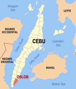
Oslob, Cebu
Oslob, officially the Municipality of Oslob, (Cebuano: Lungsod sa Oslob; Tagalog: Bayan ng Oslob), is a 4th class municipality in the province of Cebu, Philippines. According to the 2015 census, it has a population of 27,893 people.[3]
Oslob | |
|---|---|
| Municipality of Oslob | |
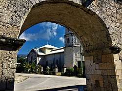 View of Oslob Church from the Spanish Cuartel | |
 Map of Cebu with Oslob highlighted | |
OpenStreetMap 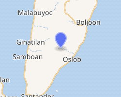
| |
.svg.png) Oslob Location within the Philippines | |
| Coordinates: 9°33′N 123°24′E | |
| Country | |
| Region | Central Visayas (Region VII) |
| Province | Cebu |
| District | 2nd district of Cebu |
| Founded | 1848 |
| Barangays | 21 (see Barangays) |
| Government | |
| • Type | Sangguniang Bayan |
| • Mayor | Jose C. Tumulak Jr. |
| • Vice Mayor | Christopher A. Amit |
| • Congressman | Wilfredo S. Caminero |
| • Electorate | 20,707 voters (2019) |
| Area | |
| • Total | 134.75 km2 (52.03 sq mi) |
| Elevation | 7.4 m (24.3 ft) |
| Population (2015 census)[3] | |
| • Total | 27,893 |
| • Density | 210/km2 (540/sq mi) |
| • Households | 5,978 |
| Economy | |
| • Income class | 4th municipal income class |
| • Poverty incidence | 35.73% (2015)[4] |
| • Revenue (₱) | 188,164,597.56 (2016) |
| Time zone | UTC+8 (PST) |
| ZIP code | 6025 |
| PSGC | |
| IDD : area code | +63 (0)32 |
| Climate type | tropical climate |
| Native languages | Cebuano Tagalog |
Oslob is bordered to the north by the town of Boljoon, to the west are the towns of Ginatilan And Samboan, to the east is the Cebu Strait, and to the south is the town of Santander.
Geography
Topography
Generally, topography of the area is hilly and rolling, dominated by open grasslands and second growth forest. There are fairly level and rolling plateaus and valleys spread throughout the interior. These are some of the most suitable areas for upland agriculture. The highest mountain peak is 800 metres (2,600 ft) above sea level.
Soil Type
Faraon clay steep phase; Medellin clay Lugo clay
Land Classification
|
|||||||||||||||||||||||||||||||||||||||||

Climate
The municipality of Oslob belongs to Coronas climate type III with a dry season from February to September and the wet season from October.
| Climate data for Oslob, Cebu | |||||||||||||
|---|---|---|---|---|---|---|---|---|---|---|---|---|---|
| Month | Jan | Feb | Mar | Apr | May | Jun | Jul | Aug | Sep | Oct | Nov | Dec | Year |
| Average high °C (°F) | 29 (84) |
29 (84) |
30 (86) |
32 (90) |
31 (88) |
30 (86) |
30 (86) |
30 (86) |
30 (86) |
29 (84) |
29 (84) |
29 (84) |
30 (86) |
| Average low °C (°F) | 23 (73) |
23 (73) |
23 (73) |
24 (75) |
25 (77) |
25 (77) |
24 (75) |
24 (75) |
24 (75) |
24 (75) |
24 (75) |
23 (73) |
24 (75) |
| Average precipitation mm (inches) | 35 (1.4) |
28 (1.1) |
38 (1.5) |
51 (2.0) |
125 (4.9) |
195 (7.7) |
194 (7.6) |
173 (6.8) |
180 (7.1) |
192 (7.6) |
121 (4.8) |
64 (2.5) |
1,396 (55) |
| Average rainy days | 9.2 | 8.2 | 9.9 | 11.3 | 22.5 | 27.3 | 28.0 | 27.2 | 27.1 | 26.9 | 19.7 | 12.7 | 230 |
| Source: Meteoblue [5] | |||||||||||||
Barangays
.jpg)
Oslob comprises 21 barangays:
| PSGC | Barangay | Population | ±% p.a. | |||
|---|---|---|---|---|---|---|
| 2015[3] | 2010[6] | |||||
| 072235001 | Alo | 5.0% | 1,395 | 1,389 | 0.08% | |
| 072235002 | Bangcogon | 4.0% | 1,108 | 952 | 2.93% | |
| 072235003 | Bonbon | 4.7% | 1,303 | 1,226 | 1.17% | |
| 072235004 | Calumpang | 3.9% | 1,080 | 941 | 2.66% | |
| 072235007 | Can‑ukban | 1.9% | 522 | 525 | −0.11% | |
| 072235005 | Canangca‑an | 2.1% | 591 | 603 | −0.38% | |
| 072235009 | Cansalo‑ay | 2.1% | 584 | 487 | 3.52% | |
| 072235006 | Cañang | 3.7% | 1,044 | 1,010 | 0.63% | |
| 072235010 | Daanlungsod | 5.8% | 1,612 | 1,556 | 0.68% | |
| 072235011 | Gawi | 6.0% | 1,685 | 1,509 | 2.12% | |
| 072235012 | Hagdan | 2.3% | 652 | 670 | −0.52% | |
| 072235014 | Lagunde | 10.1% | 2,830 | 2,829 | 0.01% | |
| 072235015 | Looc | 4.2% | 1,163 | 1,048 | 2.00% | |
| 072235016 | Luka | 4.4% | 1,241 | 1,106 | 2.22% | |
| 072235017 | Mainit | 5.0% | 1,394 | 1,312 | 1.16% | |
| 072235018 | Manlum | 1.5% | 414 | 456 | −1.82% | |
| 072235019 | Nueva Caceres | 4.0% | 1,129 | 991 | 2.51% | |
| 072235020 | Poblacion | 15.1% | 4,224 | 4,037 | 0.87% | |
| 072235021 | Pungtod | 5.6% | 1,555 | 1,421 | 1.73% | |
| 072235023 | Tan‑awan | 5.1% | 1,429 | 1,169 | 3.90% | |
| 072235024 | Tumalog | 3.4% | 938 | 879 | 1.24% | |
| Total | 27,893 | 26,116 | 1.26% | |||
Demographics
| Population census of Oslob | |||||||||||||||||||||||||||||||||||||||||||||||||
|---|---|---|---|---|---|---|---|---|---|---|---|---|---|---|---|---|---|---|---|---|---|---|---|---|---|---|---|---|---|---|---|---|---|---|---|---|---|---|---|---|---|---|---|---|---|---|---|---|---|
|
| ||||||||||||||||||||||||||||||||||||||||||||||||
| Source: Philippine Statistics Authority[3][6][7][8] | |||||||||||||||||||||||||||||||||||||||||||||||||
Economy
Public Markets: 2
Toslob Festival
The official festival of Oslob is the annual Toslob Festival which coincides with the feast of the Immaculate Concepcion in December.[9]
The official was originally named Sadsad Festival (which started as a barangay festival of Poblacion) and then was renamed to Sadsadayon Festival, but was changed again to Toslob Festival.
Tourist attractions
Baluarte
The Baluarte (Spanish for watchtower) of Oslob was built in 1788. Its main purpose was to provide a safe place wherein guards could observe the surrounding area. It was a part of the defense system in dispelling the Moro raiders of the past, which included 6 other watchtowers along the coastline of Oslob.[10] Just near the cuartel, are the ruins of an ancient watchtower. So effective was this system that in 1815, the townspeople of Oslob were able to repel one such attack and remain at peace ever since. This prompted them to relocate the town to its present site from their fortified settlement in Daanglungsod, which is now in ruins but still breathtaking.[10]
Church of the Immaculate Conception
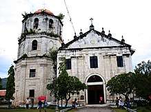
Oslob was established as a visita of Boljoon in 1690 and became an independent parish in 1848 with the Immaculate Conception as its patroness. The present-day church of cut coral stone was started in 1830 and finished 18 years later. The buttresses that were added between 1848 and 1850. The adjacent bell tower was built in 1858. The church was burned down during the Second World War liberating Philippine Commonwealth troops and Cebuano guerillas against the Japanese in Oslob in 1945, and 1955 but was eventually restored.
Outside the walls are the remains of a watchtower, one of the many that line the southeastern coast of the Cebu.
The church is connected to the parish house or convento that still has its original clay-tiled roof. Across the road from the church is the former mortuary chapel with a pediment decorated with a relief of a human skeleton. North of the complex is a small road that leads to the old cemetery.
In 2008, a fire gutted the 19th-century church's interior, including the altar and adjacent rectory, but it spared the image of Our Lady of Immaculate Conception, which is inside a glass case, and the 73 other icons near the door to the bell tower.[11]
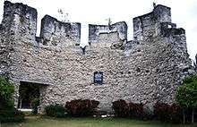
Cuartel

Located front right of the church of Oslob, just outside the perimeter stone fence and near the sea, at the intersection of Calle Aeternidad and the end of Calle Aragones, stands an unfinished building made of coral blocks resembling a Spanish-era barracks. This was intended to be the cuartel, barracks for Spanish soldiers or guardia civil. It was started about 1860, but remained unfinished at the end of Spanish occupation in 1898.[12]
Sumilon Island
Sumilon Island is a 24-hectare (59-acre) coral island off the coast of Bancogon, Oslob, Cebu.[13] The island hosts the Sumilon Bluewater Island Resort which developed the island into an eco-friendly haven for those who want to get away from the stress of city living.[14]
The island of Sumilon is located in the southeastern tip of Oslob. It is the first marine protected area in the Philippines; created as a marine sanctuary in 1974 under the guidance of the Silliman University Marine Reserve of Dumaguete City in the nearby province of Negros Oriental.[15]
The island is famous throughout the country and internationally for the exceptional beauty of its dive sites. Sumilon has four major dive sites, which are Garden Eel Plaza, Nikki's Wall, Coral Landscape and Julie's Rock. The island's diving sites are famous for their superb visibility, stunning reefs and abundance of varied tropical marine species that provide an ideal and memorable dive. There are occasional sightings of black tip sharks during dives. A popular attraction in Sumilon Island is its sandbar because of its changing shapes and shifting locations around the island depending on the season. Other places of interest in the island are a natural lagoon with high mangroves and natural caves used by fishermen to seek refuge during storms, and a lake. On the south portion of the island, a lighthouse rests on a protected tree park and beside it is a "baluarte", a historical watchtower built as part of a warning system to thwart slavers and marauders in the 19th century.
Besides diving, there is also bird-watching, picnicking, fishing, hiking, island tours, paddling and trekking. The island is 125 kilometres (78 mi) from Cebu City and separated from the mainland by the Cebu Strait. It is also close to Dumaguete in the nearby island province of Negros Oriental.
From the port of Oslob, there are various boats to the island. Another route to Sumilon Island is via Dumaguete City since it is also close to the island.[16]
Whale shark watching
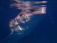
Whale sharks can be spotted in Tan‑awan which is 10 kilometres (6.2 mi) from the center of the town. It has become a popular tourist attraction. Local fishermen feed the whale sharks by hand which tourists find entertaining.
In the vicinity of whale shark swimming is a recent attraction: Tumalog Falls. Most tourists and visitors who go whale shark swimming in Tanawan usually include this waterfall in their itinerary.[17]
Transportation
- National Road: 20.00 kilometres (12.4 mi)
- Provincial Road: 22.00 kilometres (13.7 mi)
- Municipal Road : 5.75 kilometres (3.6 mi)
- Barangay Road : 32.50 kilometres (20.2 mi)
Education
Schools (public & private):
- Elementary: 13
- High Schools:6
- College: 1
References
- "Municipality". Quezon City, Philippines: Department of the Interior and Local Government. Retrieved 31 May 2013.
- "Province: Cebu". PSGC Interactive. Quezon City, Philippines: Philippine Statistics Authority. Retrieved 12 November 2016.
- Census of Population (2015). "Region VII (Central Visayas)". Total Population by Province, City, Municipality and Barangay. PSA. Retrieved 20 June 2016.
- "PSA releases the 2015 Municipal and City Level Poverty Estimates". Quezon City, Philippines. Retrieved 12 October 2019.
- "Oslob: Average Temperatures and Rainfall". Meteoblue. Retrieved 10 May 2020.
- Census of Population and Housing (2010). "Region VII (Central Visayas)". Total Population by Province, City, Municipality and Barangay. NSO. Retrieved 29 June 2016.
- Censuses of Population (1903–2007). "Region VII (Central Visayas)". Table 1. Population Enumerated in Various Censuses by Province/Highly Urbanized City: 1903 to 2007. NSO.
- "Province of Cebu". Municipality Population Data. Local Water Utilities Administration Research Division. Retrieved 17 December 2016.
- Department of Tourism 2015.
- Cabigas 2009.
- Inquirer 2008.
- Cabigas 2008.
- 9°25′58″N 123°23′09″E
- Henares 2010.
- Alcala & Russ (2006) cited in "Apo and Sumilon Islands, Philippines". Protect Planet Ocean. 2009. Archived from the original on 10 November 2011.
- Everything Cebu 2011.
- Cabigas 2014.
- Talia, Salcedo. "Enchanting Beauty of Tumalog Falls". cebuboholadventure.com.
Sources
- Alcala, A. C.; Russ, G. R. (2006). "No-take marine reserves and reef fisheries management in the Philippines: a new people power revolution". Ambio. 35 (5): 245–254. doi:10.1579/05-a-054r1.1. PMID 16989509.CS1 maint: ref=harv (link)
- Cabigas, Estan (24 June 2008). "The unfinished cuartel of Oslob". Archived from the original on 24 December 2014. Retrieved 2 November 2015.CS1 maint: ref=harv (link)
- Cabigas, Estan (21 September 2009), "Cebu's lonely sentinels of the sea" (Photographic essay), Langyaw, archived from the original on 24 December 2014, retrieved 12 February 2015CS1 maint: ref=harv (link)
- Cabigas, Estan (19 November 2014), "Have you been to Tumalog Falls?" (Photographic essay), Langyaw, archived from the original on 12 February 2015, retrieved 12 February 2015CS1 maint: ref=harv (link)
- Department of Tourism. "The Philippines Ultimate Travel Guide for Tourist – Festivals and Events >> Province of Cebu". Retrieved 2 November 2015.
- "Sumilon Island". Everything Cebu. 2011. Archived from the original on 2 November 2015. Retrieved 2 November 2015.CS1 maint: ref=harv (link)
- Henares, Ivan Anthony (17 March 2010). "Cebu: Sumilon Island's Sumilon Bluewater Island Resort". Archived from the original on 2 November 2015. Retrieved 2 November 2015.CS1 maint: ref=harv (link)
- The Inquirer, Jhunnex Napallacan (26 March 2008). "Fire guts 19th-century church in Cebu". Archived from the original on 26 March 2008.CS1 maint: ref=harv (link)
External links
| Wikimedia Commons has media related to Oslob, Cebu. |
Cebu City (capital) | |
| Municipalities |
|
| Component cities | |
| Highly urbanized cities | (Administratively independent from the province but grouped under Cebu by the Philippine Statistics Authority. However, qualified voters in Mandaue are allowed to vote in elections for Cebu provincial officials by virtue of Republic Act No. 6641, in accordance with Section 452-c of the Local Government Code of 1991.) |