Nova Scotia Highway 103
Highway 103 is an east-west highway in Nova Scotia that runs from Halifax to Yarmouth.
| ||||
|---|---|---|---|---|
| Fishermen's Memorial Highway | ||||
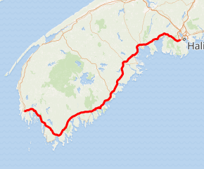
Highway 103 highlighted in red | ||||
| Route information | ||||
| Maintained by Nova Scotia Department of Transportation and Infrastructure Renewal | ||||
| Length | 291.3 km[1] (181.0 mi) | |||
| Existed | 1949–present | |||
| Major junctions | ||||
| East end | ||||
| West end | Hardscratch Road in Yarmouth | |||
| Location | ||||
| Counties | Halifax Regional Municipality, Lunenburg, Queens, Shelburne, Yarmouth | |||
| Towns | Yarmouth, Shelburne, Bridgewater, Lunenburg, Mahone Bay | |||
| Highway system | ||||
| Provincial highways in Nova Scotia 100-series
| ||||

The highway follows a route of 291 kilometres (181 mi) along the province's South Shore region fronting the Atlantic coast. The route parallels its predecessor, local Trunk 3. The highway varies from 2-lane controlled access to 2-lane local secondary roads on the section between Yarmouth and Hebbville. East of Hebbville to Upper Tantallon, the highway is 2-lane controlled access, with the exception of a 3 km (2 mi) 4-lane divided freeway near Chester. From Upper Tantallon (Exit 5), to the interchange with Highway 102 (near Bayers Lake) in Halifax, the highway is 4-lane divided freeway. Similar to Highway 101, kilometer markers increase run west-to-east, increasing from Yarmouth to Halifax; however, exit numbers run east-to-west, increasing from Halifax to Yarmouth.
In 2013, Highway 103 was redesignated as the Fishermen's Memorial Highway.
History
The highway has developed sporadically since the 1970s, with the 2-lane controlled access portion to Bridgewater being largely responsible for the abandonment of CN Rail's South Shore line, the former Halifax and Southwestern Railway. In November 2006, construction was completed that twinned 15 kilometers of highway between Exit 3 and Exit 5.[2] In December 2006, an 8.3 kilometre bypass around Barrington was completed.[3]
In late September 2015 a new section of highway was opened to bypass the Port Joli area.[4] In November 2016, a new section was completed which bypassed Port Mouton. Residents complained that the single exit east of the community had lengthened the trip for people heading west from Port Mouton.
The new interchange in Ingramport (Exit 5A) opened in January 2017.
Work on twinning Highway 103 from Exit 5 (Tantallon) to Exit 5A (Ingramport) began in February, 2018. Construction is expected to be completed by Fall 2020. Twinning from Exit 5A (Ingramport) to Exit 6 (Hubbards) will start in 2020 with an expected completion date of 2023.
Names of Highway 103
- Fishermen's Memorial Highway - June 2013
- Barrington Bypass - Barrington to Oak Park, Shelburne County
- Nine Mile Road - Sable River to Jordan Falls, Shelburne County
Safety concerns
Between 2006 and 2009, there were 29 deaths on the highway.[5] In 2009, it was considered Nova Scotia's deadliest highway and was ranked the second most dangerous highway in Canada by the Canadian Automobile Association.[6][7] In 2009 alone, ten people died in automobile accidents on the highway, according to the Nova Scotia Department of Transportation and Infrastructure Renewal.[8] Between 2008 and 2012, there were 22 fatalities on the highway.[9]
In September 2018, local residents raised concern over the presence of a road sign on the highway, near the turnoff to Port Mouton, that had a very confusing appearance, looking like a patchwork of several other road signs. It was supposedly revealed when a hotel removed its billboard advertisement, revealing the sign below.[10]
Exit list
| County | Location | km[1] | mi | Exit | Destinations | Notes |
|---|---|---|---|---|---|---|
| Halifax | Halifax | 0.0 | 0.0 | 1B | Hwy 103 eastern terminus. | |
| 0.4 | 0.25 | 1D | Dunbrack Street | Eastbound exit only. | ||
| 1.2 | 0.75 | 2 | Westbound signed as exits 2A (west) and 2B (east) | |||
| Timberlea | 5.6 | 3.5 | 3 | |||
| Hubley | 12.7 | 7.9 | 4 | |||
| Upper Tantallon | 19.6 | 12.2 | 5 | |||
| | 29.9 | 18.6 | 5A | |||
| Lunenburg | Hubbards | 40.8 | 25.4 | 6 | ||
| East River | 50.0 | 31.1 | 7 | |||
| Chester | 57.2 | 35.5 | 8 | |||
| Chester Basin | 61.3 | 38.1 | 9 | |||
| Mahone Bay | 75.0 | 46.6 | 10 | |||
| Blockhouse | 79.9 | 49.6 | 11 | |||
| Bridgewater | 91.6 | 56.9 | 12 | |||
| 91.8 | 57.0 | Crosses the LaHave River | ||||
| 94.8 | 58.9 | 13 | ||||
| Hebb's Cross | 101.4 | 63.0 | 14 | At-grade | ||
| Italy Cross | 107.9 | 67.0 | 15 | Italy Cross Road − Crousetown, Petite Riviere, Broad Cove, Rissers Beach Provincial Park | At-grade | |
| Middlewood | 111.7 | 69.4 | 16 | Hirtle Road / Camperdown School Road − Vogler's Cove, Broad Cove, Camperdown | At-grade | |
| Queens | | 122.4 | 76.1 | 17 | At-grade | |
| Crosses the Medway River | ||||||
| 124.2 | 77.2 | 17A | Port Medway Road − Mill Village, Port Medway, East/West Berlin, Charleston | At-grade | ||
| 130.5 | 81.1 | 18 | At-grade | |||
| Liverpool | 136.9 | 85.1 | 19 | |||
| 137.5 | 85.4 | Crosses the Mersey River | ||||
| | 140.3 | 87.2 | 20A | At-grade | ||
| 153.2 | 95.2 | 21 | At-grade | |||
| Port Mouton | 155.9 | 96.9 | Trunk 3 east | Intersection closed, use exit 21[11] | ||
| | 160.7 | 99.9 | 22 | Trunk 3 west – Port Joli, East Side Port l'Hébert, Kejimkujik National Park (Seaside Adjunct) | At-grade; Trunk 3 is unsigned | |
| 163.3 | 101.5 | Trunk 3 east – Port Joli | Intersection closed, use exit 22[11] | |||
| Shelburne | Sable River | 176.6 | 109.7 | 23 | At-grade | |
| Jordan Falls | 190.3 | 118.2 | 24 | At-grade | ||
| 190.8 | 118.6 | Jordan Branch Road − Jordan Branch, Jordan Ferry, Jordan Bay | At-grade | |||
| | 196.0 | 121.8 | 25 | At-grade | ||
| Shelburne | 200.0 | 124.3 | 26 | At-grade | ||
| Birchtown | 206.9 | 128.6 | 27 | At-grade | ||
| Clyde River | 220.3 | 136.9 | 28 | At-grade | ||
| Barrington | 230.0 | 142.9 | 29 | At-grade | ||
| Riverhead | 234.3 | 145.6 | 30 | |||
| Yarmouth | Pubnico | 256.0 | 159.1 | 31 | At-grade | |
| Argyle | 268.4 | 166.8 | 32 | East end of Trunk 3 unsigned concurrency; at-grade | ||
| 267.0 | 165.9 | Crosses the Argyle River | ||||
| 269.4 | 167.4 | 32A | West end of Trunk 3 unsigned concurrency; at-grade | |||
| | 276.2 | 171.6 | Eel Lake Road / Belleville Road | At-grade | ||
| 276.8– 277.4 | 172.0– 172.4 | Crosses Eel Lake | ||||
| Tusket | 281.2 | 174.7 | 33 | |||
| 282.4 | 175.5 | Crosses the Tusket River | ||||
| Yarmouth | 291.3 | 181.0 | Hardscratch Road − Brooklyn | Hwy 103 western terminus | ||
| 292.1 | 181.5 | |||||
1.000 mi = 1.609 km; 1.000 km = 0.621 mi
| ||||||
References
- Google (August 20, 2019). "Highway 103 in Nova Scotia" (Map). Google Maps. Google. Retrieved August 20, 2019.
- Highway 103 Greatly Improved
- Barrington Bypass Completed Government of Nova Scotia
- Verge, Brittany W. (October 14, 2015). "Smoothing out Highway 103: Port Joli bypass opens to traffic". Queens County Advance. Transcontinental Media. Retrieved 30 May 2017.
- Canada's most notorious highways CBC.ca
- "Nova Scotia's Highway 101 to be widened". CBC News. March 6, 2009. Retrieved 2017-06-26.
- "Archived copy". Archived from the original on 2012-04-28. Retrieved 2010-01-16.CS1 maint: archived copy as title (link) "The Top 12 Most Dangerous Highways in Canada"
- 10 most dangerous roads in Canada Archived 2010-10-21 at the Wayback Machine MSN.ca
- Highway 103 safety review launched in Nova Scotia CBC.ca
- "Is this road sign in Canada the world's most confusing?". BBC. 11 September 2018. Retrieved 13 September 2018.
- "Highway 103: Broad River to Port Joli Phase 1" (PDF). Nova Scotia Transportation & Infrastructure Renewal. Government of Nova Scotia. January 2014. Retrieved August 20, 2019.