Nova Scotia Highway 102
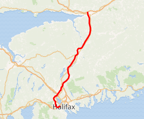
Highway 102 is a north-south highway in the Canadian province of Nova Scotia that runs from Halifax to Onslow, immediately north of the town of Truro. It is the busiest highway in Atlantic Canada.
| ||||
|---|---|---|---|---|
| Veterans Memorial Highway (Fall River to Truro) Bicentennial Drive (exit 0 to exit 5) | ||||
Highway 102 highlighted in red | ||||
| Route information | ||||
| Maintained by Nova Scotia Department of Transportation and Infrastructure Renewal | ||||
| Length | 106 km[1] (66 mi) | |||
| Existed | 1949–present | |||
| Major junctions | ||||
| South end | Bayers Road in Halifax[2] | |||
| North end | ||||
| Location | ||||
| Counties | Hants, Colchester, Halifax Regional Municipality, East Hants | |||
| Highway system | ||||
| Provincial highways in Nova Scotia 100-series
| ||||

In 2000, the section of Highway 102 between Fall River and Truro was redesignated as Veterans Memorial Highway. Between Fall River and Halifax it is known as Bicentennial Drive or the Bicentennial Highway. The numerical designation for both sections is 102.
Route description
The highway follows a 102-kilometre (63 mi) route through the central part of the province linking Highway 103, Highway 101, and Highway 118 to Highway 104, the Trans-Canada Highway.
The entire highway is a divided four-lane freeway, with the exception of a five-lane (three lanes northbound) section between the Highway 118 interchange at Miller Lake and a point between exits 6 and 7 near the Halifax International Airport at Enfield. This three-lane northbound section is not a result of particularly high traffic volumes; rather, it is a relic of the previous configuration of this section of Highway 102. Previously, the section from Fall River to near Enfield was a three-lane undivided section, including a centre passing lane favouring northbound traffic. When the highway was twinned, the three lanes were left in place for northbound traffic. Portions of Highway 102 south of the Halifax International Airport pass through several microclimates and are notorious for frequent variations in visibility due to fog caused by elevation changes.[3]
Development
The highway parallels the route of its predecessor, Trunk 2, and was developed in stages from the 1949 to the 1970s. Initially, some sections were controlled access two-lane, as well as four-lane. The route has also changed somewhat, particularly during the mid-1970s when the last part to be constructed resulted in the bypass of Shubenacadie and Stewiacke.
The initial speed limit on the highway was 100 km/h (60 mph) until 1997, when it was raised to 110 km/h (70 mph) for the section between the interchange with Highway 118 (approximately km 26) and exit 13A at Millbrook (approximately km 92). South of Highway 118 and north of Millbrook, the highway retains its original 100 km/h speed limit.
From the 1970s to the early 1990s, Highway 102 was actively patrolled by the RCMP using aerial surveillance for speed limit violations. The aerial surveillance program was restarted in 2005.
The original portion of the highway from Bayers Road to Fall River was opened in October 1958, the bicentennial year of the First General Assembly of Nova Scotia (1758); as such, it is the oldest section of controlled access highway in Atlantic Canada. This portion of the highway was officially named Bicentennial Drive, but it has become known as the "Bicentennial Highway", often shortened to "Bi-Hi", even in official documents.
Future development
Highway 102 near Halifax was the subject of a 2009 study called Highway 102 Corridor Study which examined the performance of the existing highway and projected which upgrades will be required in the future.
The proposed Highway 113 would create a new interchange between Larry Uteck Boulevard (Exit 2B) and Hammonds Plains Road (Exit 3). Highway 113 is intended to be a connector from Highway 102 to Highway 103, serving as a bypass to the heavily traveled Hammonds Plains Road (Route 213). Highway 113 is not yet budgeted and in addition some opposition has been mounted due to the route proposed.
- Interchange for Larry Uteck Boulevard
A new interchange at Larry Uteck Boulevard (designated Exit 2B) was opened in 2010 between Exits 2 (Kearney Lake Road) and 3 (Hammonds Plains Road). It has since been connected on the west side of the interchange to Kearney Lake Road.
This is the first major interchange to be built on Highway 102 since the mid-1990s and is intended to serve the rapidly growing community of Bedford South and the future area of Bedford West. The interchange is based on the traditional diamond layout but uses roundabouts instead of signalized intersections.
As part of this project, Larry Uteck Boulevard was extended to the new interchange and now provides a direct connection between Highway 102 and Bedford Highway, serving new residential retail areas. A good chunk of Kearney Lake Rd was also renamed after the dead football player/coach in an obvious effort to please developers.
- Highway 102/Highway 103/Dunbrack Street Interchange Project
Between 2018 and 2020, the interchange underwent a $20 million upgrade. The project included replacement of the Highwy 103 overpass across Highway 102, minor northbound ramp realignments, major reconfiguration of southbound ramps, installation of new lighting, and installation of a tunnel beneath Highway 103.
Construction began with clear cutting in early 2018, with construction of the new, 4-lane overpass and tunnel commencing shortly thereafter. The new overpass and tunnel were constructed next to the old overpass to minimize traffic disruption. The interchange was closed between December 6-8, 2019 to demolish the old overpass.
On March 19, 2020, the new tunnel beneath Highway 103 opened, marking the completion of the southbound ramp reconfiguration. Ramps on the northbound side of Highway 102 were only realigned slightly to align with the new overpass. Ramps on the southbound side of Highway 102 saw a larger reconfiguration. Exit 1D to Dunbrack street on Highway 102 was closed, replaced by access via Exit 1A and the new tunnel. Access to Highway 102 southbound from Highway 103 is accessed by a realigned Exit 1B which passes over the tunnel. Access to Dunbrack street from Highway 103 is now accessed directly by a new Exit 1D which merges with the output of the tunnel.
- Congestion
Traffic volumes on Highway 102 between Highway 101 and Bayers Road vary between 40,000 and 53,000 vehicles per day. Many motorists still prefer using the older 2-lane Bedford Highway (Trunk 2), which in comparison has volumes between 18,000 and 25,000 vpd and operates at or near 100% capacity through much of its length during peak periods.
Access on the Halifax Peninsula
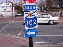
The 4-lane divided freeway portion of Highway 102 ends at Bayers Road in the west end of the Halifax Peninsula. Some streets on the Halifax Peninsula are signed with Highway 102 directional markers, with the word "INBOUND" marking a path from the end of the freeway section into the downtown core, and "OUTBOUND" marking the reverse path from the same terminus in the downtown core to the start of the freeway. These streets do not appear to be officially part of Highway 102.
Access between Highway 111 and Highway 102 is provided via Connaught Avenue north from Bayers Road and the Windsor Street Exchange to the A. Murray MacKay Bridge. This is not an officially signed route and uses municipal streets to facilitate the connection.
- Inbound
The "inbound" route markers are posted east on Bayers Road, south on Connaught Avenue, east on Quinpool Road, south on Bell Road, then east on Sackville Street to the intersection with Lower Water Street.
- Outbound
The "outbound" markers are posted beginning north on Lower Water Street, west on Cogswell Street, west on Quinpool Road, north on Connaught Avenue, west on Bayers Road.
Communities served
Communities served along the highway include, from south to north:
- Halifax (the former city)
- Fairview
- Clayton Park
- Rockingham
- Bedford
- Lower Sackville
- Fall River
- Halifax Stanfield International Airport
- Enfield
- Elmsdale
- Shubenacadie
- Stewiacke
- Brookfield
- Millbrook First Nation
- Truro
- Onslow
Exit list
From south to north:
| County | Location | km[1] | mi | Exit | Destinations | Notes |
|---|---|---|---|---|---|---|
| Halifax | Halifax | −5.3 | −3.3 | Cogswell Street, Barrington Street, Hollis Street | Interchange; Outbound Hwy 102 follows Cogswell Street | |
| −4.1 | −2.5 | Robie Street, Bell Road | Becomes Quinpool Road | |||
| −2.9 | −1.8 | Connaught Avenue | Outbound Hwy 102 turns onto Connaught Avenue | |||
| −2.4 | −1.5 | Chebucto Road – Macdonald Bridge, Dartmouth | ||||
| −1.6 | −0.99 | Bayers Road | Outbound Hwy 102 turns onto Bayers Road | |||
| 0.0 | 0.0 | Bayers Road, Mailing Street | At grade; official Hwy 102 southern terminus[2] | |||
| 0.5 | 0.31 | 0 | Joseph Howe Drive | Inbound exit; outbound entrance | ||
| 1.9 | 1.2 | 1D | Dunbrack Street (Trunk 32) | No southbound exit; exits 1K/1H on Trunk 32; Trunk 32 is unsigned | ||
| 2.7 | 1.7 | 1A | ||||
| Dunbrack Street (Trunk 32) | Southbound exit only | |||||
| 5.1 | 3.2 | 2A | Lacewood Drive — Bayers Lake | |||
| 8.1 | 5.0 | 2 | Kearney Lake Road | |||
| 10.1 | 6.3 | 2B | Larry Uteck Boulevard | |||
| Bedford | 13.1 | 8.1 | 3 | Northbound signed as exits 3A (east) and 3B (west) | ||
| 17.0 | 10.6 | 4A | Exits 1G/1H on Hwy 101 | |||
| 4B | ||||||
| 18.4 | 11.4 | 4C | Duke Street / Glendale Avenue | |||
| Fall River | 25.2 | 15.7 | 5 | Northbound access to Hwy 118 | ||
| 25.5 | 15.8 | — | Southbound exit, northbound entrance | |||
| | 32.3 | 20.1 | 5A | |||
| 35.6 | 22.1 | 6 | ||||
| Enfield | 41.0 | 25.5 | 7 | |||
| Hants | Elmsdale | 47.9 | 29.8 | 8 | ||
| Milford | 58.2 | 36.2 | 9 | |||
| Shubenacadie | 65.2 | 40.5 | 10 | |||
| Colchester | Stewiacke | 71.1 | 44.2 | 11 | ||
| Brookfield | 84.4 | 52.4 | 12 | |||
| Millbrook First Nation | 93.6 | 58.2 | 13A | Treaty Trail / Tower Road | ||
| Truro | 96.2 | 59.8 | 13 | |||
| 98.2 | 61.0 | 14 | South end of Trunk 2 concurrency | |||
| Onslow | 99.6 | 61.9 | 14A | Northbound exit, southbound entrance; north end of Trunk 2 concurrency | ||
| 100.8 | 62.6 | 15 | Signed as exits 15E (east) and 15W (west); exit 15 on Hwy 104 | |||
1.000 mi = 1.609 km; 1.000 km = 0.621 mi
| ||||||
References
- Google (July 30, 2017). "Highway 102 in Nova Scotia" (Map). Google Maps. Google. Retrieved July 30, 2017.
- "Bayers Road / Highway 102 / Highway 107 Corridor Study" (PDF). Halifax Regional Municipality. February 2009. Archived from the original (PDF) on March 27, 2009.
- Resources, compiled by Interpretation (2006). Nova Scotia street & road atlas. Halifax, N.S.: Nimbus Pub. p. 39W3. ISBN 1-55109-563-7.