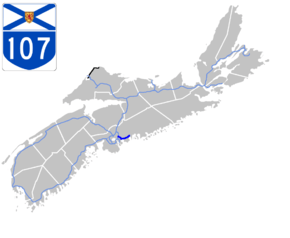
Nova Scotia Highway 107
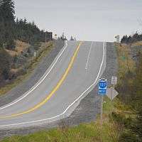
Highway 107 in Nova Scotia runs through the eastern suburbs of the Halifax Regional Municipality, from the Burnside Industrial Park in Dartmouth to an intersection with Trunk 7 in Musquodoboit Harbour. It is 43.2 km (26.8 mi) long, and is mostly two lane, controlled access highway.
| ||||
|---|---|---|---|---|
 | ||||
| Route information | ||||
| Maintained by Nova Scotia Department of Transportation and Infrastructure Renewal | ||||
| Length | 43.2 km[1] (26.8 mi) | |||
| Existed | 1978–present | |||
| Major junctions | ||||
| West end | Burnside Drive in Dartmouth | |||
| East end | ||||
| Highway system | ||||
| Provincial highways in Nova Scotia 100-series
| ||||

Route description
From its current western terminus at the intersection of Akerley Boulevard and Burnside Drive in Burnside,[1] Highway 107 travels northeast to its interchange with Highway 118, then continues southeast on the Forest Hills Extension to an intersection of Main Street in Dartmouth and Trunk 7 in Westphal. The highway then travels east, concurrent with Trunk 7, through the Sunset Acres neighbourhood in Westphal and the community of Cherry Brook for about 5 km (3.1 mi). Near Preston, Highway 107 and Trunk 7 split, and Highway 107 continues eastward as a controlled access two-lane highway for the remainder of its route. The highway travels past the communities of Preston, Lake Echo, Porters Lake and Head of Chezzetcook before reaching its eastern terminus with Trunk 7 west of Musquodoboit Harbour.
Future
There are plans in the near future to extend Highway 107 from Akerley Boulevard along the eastern shore of Anderson Lake and from there, either turn east to connect to the Bedford Bypass, or continue north to connect to Duke Street/Glendale Avenue near exit 4C on Highway 102. This extension may also be known as the Burnside Expressway. This extension would allow commuters from Halifax and Burnside heading to Sackville to bypass the Bedford Bypass and Windmill Road and instead go through Burnside and connect directly into Sackville. Construction is expected to take place within the next few years.[2]
Exit list
The entire route is located in Halifax Regional Municipality.
| Location | km[1] | mi | Exit | Destinations | Notes | |
|---|---|---|---|---|---|---|
| Dartmouth | −2.2 | −1.4 | At grade; west end of Akerley Boulevard | |||
| 0.0 | 0.0 | Burnside Drive | At-grade; Hwy 107 western terminus | |||
| 0.8 | 0.50 | Gloria McCluskey Avenue, John Savage Avenue | At-grade; east end of Akerley Boulevard | |||
| 3.0 | 1.9 | 13 | Signed as exit 13S (south) and 13N (north); exit 13 on Hwy 118 | |||
| 6.6 | 4.1 | 14 | ||||
| 11.7 | 7.3 | At grade; western end of Trunk 7 concurrency | ||||
| Cherry Brook | 14.6 | 9.1 | At-grade | |||
| | 16.1 | 10.0 | 17 | At grade; eastern end of Trunk 7 concurrency | ||
| Mineville | 20.6 | 12.8 | 18 | |||
| Porters Lake | 27.8 | 17.3 | 19 | Eastbound exit, westbound entrance | ||
| 29.6 | 18.4 | 20 | ||||
| | 34.1 | 21.2 | 21 | Eastbound exit, westbound entrance | ||
| Musquodoboit Harbour | 41.0 | 25.5 | At-grade; Hwy 107 eastern terminus | |||
1.000 mi = 1.609 km; 1.000 km = 0.621 mi
| ||||||
External links
References
- Google (July 14, 2017). "Highway 107 in Nova Scotia" (Map). Google Maps. Google. Retrieved July 14, 2017.
- Traffic Study for Highway 107 Phase 1 – Burnside to Sackville (PDF). Province of Nova Scotia (Report). Genivar. February 2011.