Na Duang District
Na Duang (Thai: นาด้วง; IPA: [nāː dûaŋ]) is a district (amphoe) in the eastern part of Loei Province, northeastern Thailand.
Na Duang นาด้วง | |
|---|---|
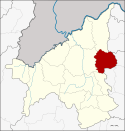 District location in Loei Province | |
| Coordinates: 17°28′45″N 101°58′14″E | |
| Country | Thailand |
| Province | Loei |
| Seat | Na Duang |
| Area | |
| • Total | 590.0 km2 (227.8 sq mi) |
| Population (2005) | |
| • Total | 25,232 |
| • Density | 42.8/km2 (111/sq mi) |
| Time zone | UTC+7 (ICT) |
| Postal code | 42210 |
| Geocode | 4202 |
History
The area of the district was originally Ban Na Duang of Udon Thani Province, a village named after the hunter Duang. He led people to establish a new village in 1881. Later the village was assigned to be part of tambon Thung Pho, Mueang Loei District in 1945 and tambon Na Din Dam in 1967. In 1976 it was upgraded to a tambon. Together with three more tambons it formed a minor district (king amphoe) on 17 January 1977.[1] It was upgraded to a full district on 19 July 1991.[2]
Geography
Neighboring districts are (from the south clockwise): Erawan, Mueang Loei, Pak Chom of Loei Province; Nam Som of Udon Thani Province; and Suwannakhuha, Na Klang and Na Wang of Nong Bua Lamphu Province.
Administration
The district is divided into four sub-districts (tambons), which are further subdivided into 41 villages (mubans). Na Duang is a township (thesaban tambon) which covers parts of tambon Na Duang. There are a further four tambon administrative organizations (TAO).
| No. | Name | Thai name | Villages | Pop. | |
|---|---|---|---|---|---|
| 1. | Na Duang | นาด้วง | 12 | 9,359 | |
| 2. | Na Dok Kham | นาดอกคำ | 17 | 9,433 | |
| 3. | Tha Sa-at | ท่าสะอาด | 7 | 3,546 | |
| 4. | Tha Sawan | ท่าสวรรค์ | 5 | 2,894 |
References
- ประกาศกระทรวงมหาดไทย เรื่อง แบ่งท้องที่อำเภอเมืองเลย จังหวัดเลย ตั้งเป็นกิ่งอำเภอนาด้วง (PDF). Royal Gazette (in Thai). 94 (10 ง): 366. 1 February 1977.
- พระราชกฤษฎีกาตั้งอำเภอทุ่งตะโก อำเภอพะโต๊ะ อำเภอเขาค้อ อำเภอน้ำหนาว อำเภอวังจันทร์ อำเภอนาด้วง อำเภอเต่างอย อำเภอสิงหนคร อำเภอพระสมุทรเจดีย์ และอำเภอลำดวน พ.ศ. ๒๕๓๔ (PDF). Royal Gazette (in Thai). 108 (107 ก Special): 29–33. 19 June 1991.