Na Wang District
Na Wang District (Thai: นาวัง; IPA: [nāː wāŋ]) is a district (amphoe) in the western part of Nong Bua Lamphu Province, northeastern Thailand.
Na Wang นาวัง | |
|---|---|
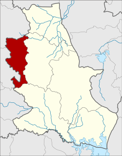 District location in Nong Bua Lamphu Province | |
| Coordinates: 17°19′22″N 102°4′21″E | |
| Country | Thailand |
| Province | Nong Bua Lamphu |
| Seat | Na Lao |
| Area | |
| • Total | 326.4 km2 (126.0 sq mi) |
| Population (2005) | |
| • Total | 37,316 |
| • Density | 114.3/km2 (296/sq mi) |
| Time zone | UTC+7 (ICT) |
| Postal code | 42170 |
| Geocode | 3906 |
Geography
Neighboring districts are (from the east clockwise): Na Klang and Si Bun Rueang of Nong Bua Lamphu Province and Erawan and Na Duang of Loei Province.
History
The district was established on 30 April 1994, when five tambons were split off from Na Klang District.[1] It was upgraded to a full district on 11 October 1997.[2]
Administration
The district is divided into five sub-districts (tambons), which are further subdivided into 51 villages (mubans). Na Lao is a township (thesaban tambon) which covers parts of tambons Na Lao and Thep Khiri. There are a further five tambon administrative organizations (TAO).
| No. | Name | Thai name | Villages | Pop. | |
|---|---|---|---|---|---|
| 1. | Na Lao | นาเหล่า | 13 | 8,778 | |
| 2. | Na Kae | นาแก | 10 | 8,139 | |
| 3. | Wang Thong | วังทอง | 12 | 8,672 | |
| 4. | Wang Pla Pom | วังปลาป้อม | 8 | 6,848 | |
| 5. | Thep Khiri | เทพคีรี | 8 | 4,879 |
References
- ประกาศกระทรวงมหาดไทย เรื่อง แบ่งเขตท้องที่อำเภอนากลาง จังหวัดหนองบัวลำภู ตั้งเป็นกิ่งอำเภอนาวัง (PDF). Royal Gazette (in Thai). 111 (42 ง): 15. May 26, 1994.
- พระราชกฤษฎีกาตั้งอำเภอหนองปรือ อำเภอห้วยกระเจา อำเภอทรายทองวัฒนา อำเภอปางศิลาทอง อำเภอเนินสง่า อำเภอนาทม อำเภอพระพรหม อำเภอแม่วงก์ อำเภอสองแคว อำเภอบ้านใหม่ไชยพจน์ อำเภอไทยเจริญ อำเภอกาบัง อำเภอพยุห์ อำเภอเมืองจันทร์ อำเภอภูพาน อำเภอคลองหอยโข่ง อำเภอเขาฉกรรจ์ อำเภอนาวัง อำเภอพิบูลย์รักษ์ และอำเภอทุ่งศรีอุดม พ.ศ. ๒๕๔๐ (PDF). Royal Gazette (in Thai). 114 (50 ก): 24–27. September 26, 1997.
This article is issued from Wikipedia. The text is licensed under Creative Commons - Attribution - Sharealike. Additional terms may apply for the media files.